![]() You don't need to be an 'investor' to invest in Singletrack: 6 days left: 95% of target - Find out more
You don't need to be an 'investor' to invest in Singletrack: 6 days left: 95% of target - Find out more
How long until this section of road is re-routed? There is a lot of effort put into keeping it open, but would it not be better to re-route it onto the other side of the glen where the hillside is not so high/steep and forest stabilises the slope? Another option would be to build an elevated section of road where landslides can pass underneath, such as at Killiecrankie. This would be very expensive and I guess it was only done at Killiecrankie due to a lack of any alternative, other than a tunnel.
If you were Bear Scotland, would you tender for the next maintenance contract?
Covered concrete canopy type thing like they do so well in the Alps. Probably the cheapest workable (although disruptive) option.
Otherwise do nothing and fix it every single time. This generally works well till a bus load of tourists gets killed.
I've no idea where it is, but given how often it gets mentioned on the radio 2 travel news, I've no desire to go there.
You should , it really is a lovely place 🙂
I would leave the other side alone but only because i like riding and walking there but i suppose it really is time they sorted it once and for all .
A paravalanche would work. I wonder if they could be prefabbed and installed relatively quickly?
What is this thread about? What I am missing?
How about the Norway model? Tunnel it.
The latest instalment of a whole lot of landslides for those wondering what it's about.
Ta.
Bit cryptic for us suvvners. Well me anyway.
https://www.bbc.co.uk/news/uk-scotland-highlands-islands-54146554
It is a 59 mile detour every time it shuts. It has shut a lot lately. It is (sadly) a good example of lack of infrastructure resilience to climate change. The older Old Military Road, built by Wade in the 1740s, is the more resilient route, but not suitable for the volume of traffic.
The hillside had been sculpted, if not stable, over a very long time. We come along and gouge chunks out. Not surprisingly it collapses back to a more stable shape.
Entropy in action.
I’ve no idea where it is, but given how often it gets mentioned on the radio 2 travel news, I’ve no desire to go there.
It's a shite part of the world. I wouldn't bother.

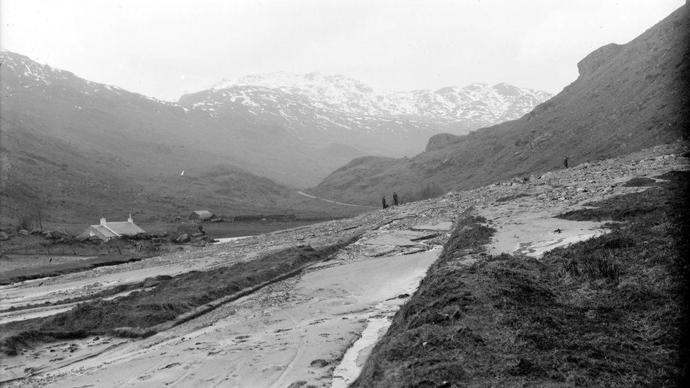
The landslides in this area have a long history. This one is 1913.
I think the modern road is in the wrong place given the landslip risk and frequency. The angle of slope is less lower down at the old road.
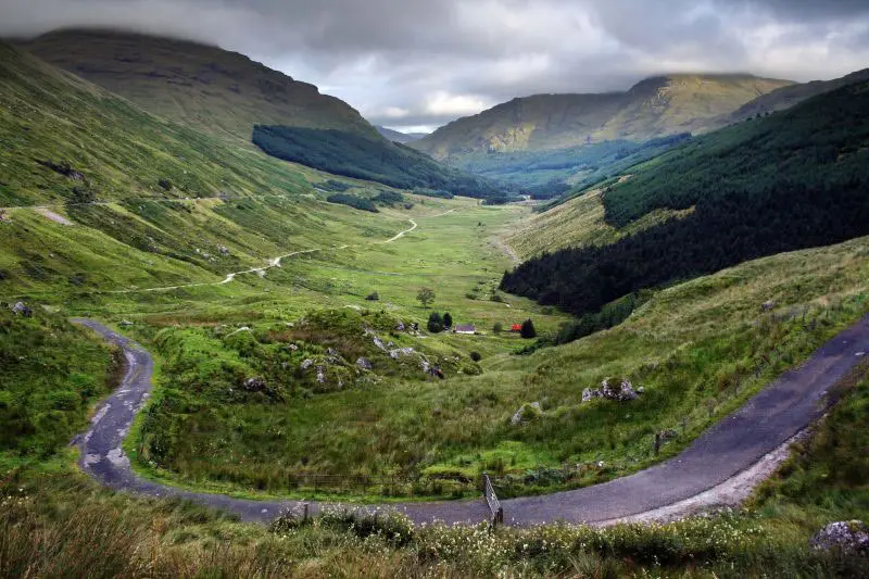
While the higher line may have had advantages in allowing an easy gradient near the top of the pass, with today's higher powered vehicles a steeper road would be acceptable. A new road should be built below the old military road until near the top of the glen and a combination of embankments and cuttings used to get over the top of the pass. If necessary the road up the glen could be built on a series of piles to allow any landslip to pass underneath or on an embankment to prevent a landslip blocking it.
I remember driving along there a couple of years ago. Lovely views. Don't they open up the old military road if the main road is closed? From memory it had gates that looked like they could facilitate this. That being said not sure if it is wide enough to support traffic in both directions.
they do use the military road - convoys both directions. However it also got hit by one of these landslides IIRC
Ah thanks TJ. I did think the military road looked great for a nice quiet ride along.
Yeah, the old road got taken out in this one as well. Apparently it's not a good candidate for an alpine-style surface tunnel thing (paravalanche?) because of the poor ground conditions, you need to build them into a good hillside. Whereas here, it'd be more like swamp castle.
There's another road on the other side of the valley, but it's (or it was, last time I was on it) pretty much a forest track.
There was a Tranport Scotland study of the problem back in 2012. They looked at various alternates and ended up recommending the cheapest - sticking with the current road and building more defences £9-10 million.
2nd option - existing road with 1Km flow shelter - £105-120M
3rd option 1.2Km on a viaduct more or less existing line £83-95M
4th and 5th - follow line of old military road, then either through tunnel at top of pass £460-520M
or curves and climbs on surface £66-75M. The tunnel max grade 4%, surface road 8% max.
6th - A new road on the other side of the Glen. £27-91M. The cheaper end would be without good landslip protection so no improvement on existing road.
All as per
If the existing road was improved as per that report I think it is fair to say it hasn't worked and time other options were looked at. They could have built a new road for a fraction of what has been spent on the two ferries that aren't built yet.
A member of this parish was heading for Aonach Eagach ridge this morning, A82 closed at Ardlui, A83 closed too, onto WM road - double diversion! ooft.
Just wait until there's (another) Glen Ogle crash and that closes...only routes North both well be A9 or ferries...
It’s a shite part of the world. I wouldn’t bother.
Matt, your photo is the Last place I'd go to.
Just wait until there’s (another) Glen Ogle crash and that closes…only routes North both well be A9 or ferries…
The standard of driving on the A82 at the weekend is horrific, and it's a motorcyclists playground around their (bizarre) meeting place at the Green welly. Road was closed just north of BOO for 6 hours when we were pedalling WHW, and on the next day on the way home, there was kamikaze overtaking on show all the way home.
I'd happily see the whole ****in road speed camera'd up to the hilt.
A member of this parish was heading for Aonach Eagach
ridgethis morning
FTFY 😉
Whatever.
I’d happily see the whole **** road speed camera’d up to the hilt.
Probably only a matter of time. There are average speed cameras now between Crianlarich and Tyndrum and a big section of the A85 (from the turn off for Killin to Crianlarich) has them too.
I don't really have an issue with them, they space the traffic out a bit more - because its all travelling at a similar speed and you can still overtake the campervans that are doing 45-50mph. It just stops dickheads hooning along at 85mph
I'm sure they have thought about this and I know I may sound like a keyboard engineer by would planting the hillside with trees not help?
I’m sure they have thought about this and I know I may sound like a keyboard engineer by would planting the hillside with trees not help?
I'm guessing the soil is so thin and loose that any planted trees would just get washed down the hill in the next downpour.
Climate change means more regular heavy downpours, the current road is going to have constant issues, so a proper long term mitigation strategy is needed.
The standard of driving on the A82 at the weekend is horrific, and it’s a motorcyclists playground around their (bizarre) meeting place at the Green well
I'm up and down that road several times a month - There are now a load of average speed camera's, but they do little to slow the motorbikes.
I have lost count of the number of near accidents I've been in with bikers overtaking in stupid places. Happened twice in the last 6 weeks alone - Last time I went north 2 weekends ago a bike overtook me when a car was oncoming. I had to do an emergency brake to allow the biker back in front of me - even at that his back wheel missed my front corner bumper by less than 12" If I never stood on the brakes he'd be a gonner now. The time before that in early august it was exactly the same set up, only I was the oncoming car in that set up.
Twice in the last 12 moths now I have been caught up in big diversions when bikers has miss timed it and killed themselves. Goodness knows what the death rate is on that road during summer!
Goodness knows what the death rate is on that road during summer!
Figures obtained through a Freedom of Information request revealed there were 785 serious or fatal accidents on the country’s trunk roads between January 2017 and summer 2019.
At least one person lost their life in 137 of them.
In the data provided by the Scottish Government to the Scottish Lib Dems, it was revealed the A82 connecting Glasgow and Inverness via Fort William is the deadliest road in the country, with 73 serious or fatal accidents taking place.
According to Sorry Mate the A82 is the most dangerous road in the UK for motorcyclists
I've actually never seen anything involving motorbikes, sadly the worst driving I've seen is people pulling ridiculous overtakes to get around cyclists, I had a c*ck in a Range Rover overtake two cars and two cyclists on an incredibly short straight before a tight corner into Taynuilt, given how close he had been sitting on my bumper the whole way I don't doubt that if there had been oncoming traffic he would just have swerved straight into the cyclists if he had had to.
The stretch between Dalmally and Taynuilt is worst as there is no practical alternative other than going all the way around the bottom of Loch Awe.
Surprised nobody has mentioned there is already another feasibility study starting up for rerouting the A83, IIRC its due for completion by spring.
[strong]oldagedpredator[/strong] wrote:
How about the Norway model? Tunnel it
That was my immediate thoughts too. We are just so behind in this country when it comes to large scale infrastructure planning. Either no ambition or just cheap-skates. No idea why we don't use tunnels more often, they solve so many issues.
This would be my suggestion for a 3 km base tunnel which would be as good as flat.
[img]  [/img]
It would simple to surface one of the forestry tracks to link inthe B road on the SE side and then completely remove the old South ramp A83 to the pass
The poor state of our transport infrastructure in remote and rural Scotland has been a massive issue for several decades. Not been addressed by governments of any colour.
irc
Free MemberIf the existing road was improved as per that report I think it is fair to say it hasn’t worked
Supposedly some of the mitigation like debris traps worked perfectly, but it was just a really bad landslide. No idea how true that is
Nobeerinthefridge
Free MemberThe standard of driving on the A82 at the weekend is horrific, and it’s a motorcyclists playground around their (bizarre) meeting place at the Green welly.
Green Welly traditionally was just one of the few places motorbike groups were really welcomed, and it has petrol. These days it's just tradition.
Green Welly traditionally was just one of the few places motorbike groups were really welcomed, and it has petrol. These days it’s just tradition.
Aye, and I'd assume it's central location for the roads out past Oban, Killin etc made it a good place to meet and ride, it's still pish mind.
gordimhor
Full MemberThe poor state of our transport infrastructure in remote and rural Scotland has been a massive issue for several decades. Not been addressed by governments of any colour.
Nail on head. The classic example being the Pulpit Rock, A82 Loch Lomond. The main route to the west highlands but one way traffic light controls for over 30 years.
In fact the entire A82 between Tarbert and Inveroran seems to have been left in the too tricky basket.
The Victorians managed to get the railway past Pulpit Rock in a cutting using fairly primitive equipment but we took 30 years to return the road to two lanes and still didn't straighten it out.
There are now a load of average speed camera’s, but they do little to slow the motorbikes.
Forward facing camera's then, no number plates on front of bikes.
In fact the entire A82 between Tarbert and Inveroran
Assume you mean Inverarnan.
The Victorians managed to get the railway past Pulpit Rock in a cutting using fairly primitive equipment but we took 30 years to return the road to two lanes and still didn’t straighten it out.
The last time I drove up the A82 I remember thinking the same thing, but also that there is no way that railway line would get built today!
Assume you mean Inverarnan.
Posted 23 minutes ago
Bugger. Always mix those two up despite many hours spent in the pubs in each.
If you were Bear Scotland, would you tender for the next maintenance contract?
Depends what the T&Cs are. I doubt they are carrying the risk!
Nail on head. The classic example being the Pulpit Rock, A82 Loch Lomond. The main route to the west highlands but one way traffic light controls for over 30 years.
Depends where you are coming from!
The poor state of our transport infrastructure in remote and rural Scotland has been a massive issue for several decades. Not been addressed by governments of any colour.
I'm not sure about "rurally" but generally its intentional - if you provide better roads you get more traffic. More traffic is bad. Of course no traffic might be worse.
If the existing road was improved as per that report I think it is fair to say it hasn’t worked
You only hear about when it hasn't worked. And so far the landslides haven't hit any traffic so successful to a degree.
And so far the landslides haven’t hit any traffic so successful to a degree.
I think this might be because they have moved to a policy of preventative closures when heavy rainfall is forecast. Given it is the west coast of Scotland, this may well prove to be inconvenient - although it will undoubtedly be safe.
Bugger. Always mix those two up despite many hours spent in the pubs in each.
by ‘despite’ do you mean ‘because of’ ?
😉
I think this might be because they have moved to a policy of preventative closures when heavy rainfall is forecast.
It’s almost certainly part of it, but it also seems to suggest they have reasonable forecasting/monitoring/prediction on when issues are likely (I don’t know how often they have closed the road and nothing happens but I think that is not too often).
Interestingly when I drove past there with my daughter a couple of years ago I asked if she (or indeed all the occupants of the car!) knew what the unusual “fences” were for (this is the level of my great chat!). She suggested they were to contain the dinosaurs! Needless to say each time we have passed since we have been watching carefully for any prehistoric creatures!
Proposed upgrade details here https://www.transport.gov.scot/news/public-asked-for-input-on-eleven-options-for-new-access-to-argyll-and-bute/
Think it's a X factor style thing where you vote for your favourite, sorry the bean counters will go for the cheapest option!
Sadly no tunnel option, but quite like the bridge options.
Particularly the ones that involve bridges from Inverclyde to Little Cumbrae to Bute then Bute to the mainland again.
The French would throw up a bridge on pillars straight up the valley. No messing.
Some of those 11 options are bat shit mental
The fixed link crossing over the Firth of Clyde will present considerable challenges. This area is used by large marine vessels as well MOD submarines which are based at Faslane and Coulport. The structure will require to span a deep section of the Firth of Clyde as well as have adequate clearance for large marine vessels.
No Shit Sherlock.
I think they have to throw in the non-starters just to head off some of the zoomers.
#4
Some of those 11 options are bat shit mental
Particularly the ones that involve bridges from Inverclyde to Little Cumbrae to Bute then Bute to the mainland again.
This. (That's still Ayrshire BTW, Bandit Country is anything north of Skelmorlie)
Who the hell thought a bridge starting on the A78 (which can be closed along with the A760 in bad weather in either direction) past the power station cooling inlet (I'm sure all the silt would be brilliant for the cooling loops) to an unpopulated private island (bypassing the one that actually has queues of folk for the ferry every nice day), then on to another island before finally hitting the peninsula in an absolute nowhere location. Avoiding the heavy marine traffic as already noted. Add in the fact it's a crappy place to get to from anywhere and that's solid gold.
To be honest anything involving a Clyde crossing is looking terrible and the local options are more of the same.
Presumably everyone at Transport Scotland is working from home and so couldn't do field visits to see how incredible some of those ideas are! I quite like the way they are thinking outside the box, but I couldn't see any data on where the start and end points were for a typical journey? e.g. if its Edinburgh to Oban or M6 to Campbeltown then the preferred options are rather different.
Just reading through the 11 options listed in the previously mentioned consultation document
Only Option 1 keeps the A83 going up the Rest and be Thankful. Surely an elevated section up the middle of the glen, well away from the landslide fallout area, is the cheapest, least disruptive and quickest permanent solution?
Options 2-11 go from ripping up unspoiled glens to having major bridges near nuclear bases or threading new routes (presumably to trunk road standard) along established routes that currently have steep hills and single track roads with passing places. The cost of any of these options rules them out, let alone the environmental, military or engineering challenges. I'd love a wee bit of whatever they are smoking, absolutely mental.
I think building at ground level through a different glen would be cheaper than an elevated road, and maybe the an elevated road would be considered more environmentally bad. The options with major bridges are clearly very expensive but I assumed they would have other economic benefits than just being a diversion round the Rest and Be Thankful (still think they won't happen though!).
TBH for all it's a pretty area there's nothing I can remember in the glens around it that is really outstanding- it's all deforested, quite a bit of modern tree farms and sheepfold but hardly untouched.
Here is how they did it at KIlliecrankie.

https://www.sabre-roads.org.uk/wiki/index.php?title=Pass_of_Killiecrankie
£11M at 1986 prices for a 2.5Km stretch of road. So likely to be expensive putting the A83 road on stilts on the existing line.
So I still think the best option would be up the middle of Glen Croe and get up the hill at the end with some mix of embankment, zigzags, cutting, and/or short tunnel.
Surely there would hae to be a road closure and inspection every time there was a landslip hitting those pillars anyway? I'm failing to see that as a viable option.
And I'd have thought that any road zig-zagging its way up the top of the glen might be similarly susceptible to landslip. Having said that, it is possible that the land profile and soil structure there makes it less likely.
there’s nothing I can remember in the glens around it that is really outstanding
There's the River Kinglas, which was one of the most amazing continuous hard creeks in the UK. Full on brilliant kayaking for mile after mile. Took my first swim on nearly 3 years on there.
https://www.ukriversguidebook.co.uk/rivers/scotland/west-highlands/photos/river-kinglas
Alas it has been dammed, but ...
Scotroutes
I think the difference at the head of the Glen is a less steep slope and also a short hillside above. There is a couple of thousands of feet draining heavy rain on to the current road. There must be a reason the old 19th century line of the military road is usually available as a bypass when the modern road is blocked.
The line of the modern A83 (yep, closed again folks...) is clearly to maintain an even gradient from Laigh Glencroe farm to the Rest viewpoint. It does this very well but traverses an increasingly unstable slope in the process. Diverting west to ascend the valley floor on stilts solves the unstable mountain issue while allowing an even gradient to be maintained. It's the obvious solution but quite spendy, hence the batshit mental consultation process listing loonball or unaffordable bridges over Rhu Narrows, Loch Long (both downstream from nuke bases) or Lesser Cumbrae to kill the whole thing dead. They need to MTFU and accept the need for a sizeable investment to prevent a tragedy, which would trigger said sizeable investment anyway. If it took Edinburgh lawyers and politicians from their work to their But & Ben in Fife it would already have been built #Queensferrycrossing
irc
Free MemberThere must be a reason the old 19th century line of the military road is usually available as a bypass when the modern road is blocked.
I don't know how true this is but a civil engineer colleague of mine told me that actually the military road gets damaged about as often as the main one, it's just that it's simpler/quicker to fix, and nobody notices as long as the main road is open. You only ever hear about a military road blockage or similar, when the A83's shut.
The OMR is much further down the slope. Most of the landslide debris peters out before it reaches the OMR. The August 5th slip was unusual in that it knocked both roads out, resulting in ferry trips for many of us. The downside of the OMR is uneven gradients and some tight bends that catch out artics, coaches and even caravanners.
Bring back the devils elbow.
That'll keep the caravans at bay.
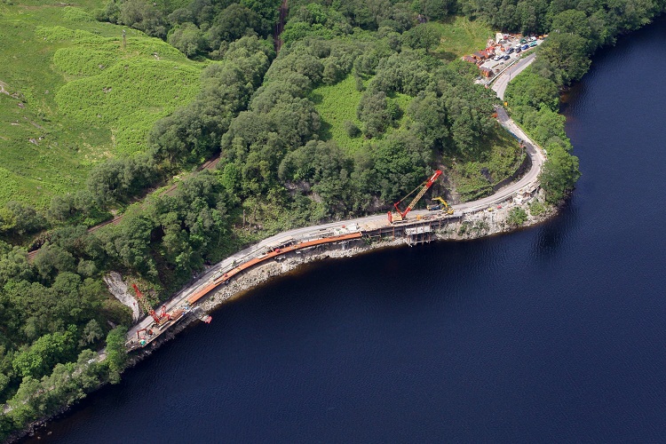
The next instalment of "investment" is underway. Link to BBC here.
I wonder how long it will take landslides of the magnitude regularly witnessed here to overwhelm a 6m high defence.
After all the consultation and proposals, "A route through Glen Croe near the existing road has now been identified."
I think there are still night closures. It is taking ages, and it is almost like the first step in the process is to train an Engineer. From scratch.
This doesn't effect me at all, but I'd be very frustrated if I needed to use this road regularly.
It seems like the new route is being chosen basically as an easier but imperfect medium term solution rather than a harder perfect fix? Which seems pretty sensible as long as it's not just basically kicking the can. I see people talking about it as the "cheap option" but easy probably means faster too.
If I read it right, they've decided to still go up Glen Croe but haven't decided what route to use yet. I bet 10p they put it up the other side of the valley and upgrade the end of the B828, any takers?