![]() You don't need to be an 'investor' to invest in Singletrack: 6 days left: 95% of target - Find out more
You don't need to be an 'investor' to invest in Singletrack: 6 days left: 95% of target - Find out more
So, i'm ultimately after recommendations for a suitable cycle specific GPS device (cheaper end of spectrum), that'll mainly be used for logging local rides, but it'll need to be capable enough to navigate me off road on a pre-planned route in unfamiliar areas to cut down map faffing. Also any help on gps basics or good resources to help me learn.
To date, I have been almost entirely analogue, and my spatial mind works in harmony with an OS map. I'll usually keep a map handy or have an offline copy on my phone, but i'm looking at how I can navigate with a bit less faff in areas i don't know so well. I can see that apps like Viewranger and OS maps are brilliant, but I never want to strap my phone to my bike or waste battery that way. If there's an app that integrates well with a gps that would be great (but not use it for navigation on the trail to not waste battery).
I've never used a gps to navigate off road (I just use a paper map, nearly always successfully), and the only times i've used a garmin on road, I hated it. I can't cope with a breadcrumb trail spinning around a tiny screen, and as i understand it you don't get turn-by-turn navigation off road unless you add it yourself? Can I get, and is it worth having navigation over a map layer (assuming more ££s)? Is it better to get the right route planned and use a breadcrumb trail? I'm not after too much faffing with technology either, just fairly straightforward planning, uploading, riding.
Thanks
You can get GPS that will help you navigate and it comes in two flavours:
Breadcrumb following - This is cheaper but relies on you setting up a reliable breadcrumb trail using their software and then following the trail either using a basic arrow or maybe a trace.
Map based - This is expensive and limited depending on the capabilities of the screen.
Personally, I'd stick with a map or use an old phone with some mapping software on.
Like you I'm big on OS maps and spatial awareness over following breadcrumb trails or an arrow on the screen. I use an old android phone (try to get a water resistant one so you don't have to resort to cling film or sandwich bags) with OS maps that I can overlay with strava heatmap or gpx routes. This works for me over breadcrumb trail as my routes are often made up, or at least modified on the fly. Battery life is the main issue, but only it becomes an issue if I spend a lot of time navigating with the screen on, or it's a long 4hr+ ride, or is very cold, and for those cases I have a spare battery. Probably a little more faffy to get setup originally but then simple in use. That said I don't have any experience of the latest crop of dedicated GPS units with mapping, Though I don't think there is anything that will handle OS, heatmap and gpx overlay.
Garmin Etrex 20x or 30x (as 20x but with compass and altimeter) does all of that* for me. All day battery life, rugged & waterproof. Downside is the small screen.
*OP's requirements, not Mark90's
i have the above GPS but in use the screen is to small if you want to change route or see where you have got lost or how to get to where you want. Fine for following a path but so is a breadcrumb as well as long a the paths are obvious.
IMHO a phone is a better option if the battery life is sufficient for your needs as the map is much bigger, easier to zoom and easier to work out. I suspect with the above garmin you will still need another map as I would not go out with just it personally [ or just one GPS with no back up] YMMV
Stop messing around and get garmin edge 800 upwards with OS mapping.
Had an 800 and then 810 for about 3 years and never looked at a paper map since.
Use bikehike to draw out routes and upload to unit.
So much easier, focusing on riding rather than navigating.
I agree with Larry rather than the others.
I've got a Garmin Edge 800 and it's great (though a few years old now, I think the newer ones have bigger screens). It's definitely meant that I've done rides that I simply wouldn't have attempted otherwise. As above, plot a route on bikehike or bikeroutetoaster and then send it to the Garmin, then go and ride. Obviously a backup map is a good idea, but then a backup map for your current map is also a good idea (what if it blows away?).
The Edge has been enough for all day (like 9am to 7pm) rides, it has survived being dropped off the bike on a rocky descent, it lasted all day the other weekend on a freezing, snowy, rainy day in the Peak District. If I lost it I wouldn't hesitate to replace it, probably with an Edge Touring (if they still do it) as I don't use the 'performance' stuff, I just want to record a ride and have the map available.
The maps look like this:
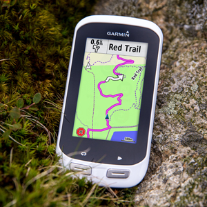
Which is loads better than a breadcrumb type display, especially if you're riding somewhere where there are lots of paths all crammed together, or if for some reason you need to change the route while you're riding, you can pan around the map to look for an alternate route.
Oh, and if you get one, use the free OSM (open source) maps rather than the expensive Ordnance Survey ones.
Thanks for the replies so far, food for thought. I have a few questions on the devices mentioned:
Are the etrex bar mounts any good? I've heard you need zip-ties? I have looked at them before, but I wouldn't want to use one as a day to day recording gps as it's a bit cumbersome - they are a good price though at the moment.
With the 800/810/820 or any of the garmins with OSM, how good is the mapping for planning though. My head is so attuned to reading OS i'm not sure how good it would be at finding a random bridleway or track, or figuring the best way to do a loop if there are no contours? My other half has a Garmin 1000, so i will borrow it to see how i get along with the mapping, but i've found attempts to use Garmin connect pretty rubbish. I guess i'd like to plot a route on a OS map, upload it, and follow it on a fairly discreet device with OS map layer - but i realise that would be expensive and/or bulky. I 've seen some reasonably priced edge touring around, so may be an option as i also don't need performance stuff. Is there full 1:25k OS map coverage available to buy for Garmins?
I'd not thought of a used android phone before, and it's certainly an interesting idea just for trips in areas i don't know - but it still means putting a phone on the bars.
In new areas i'd usually always have a spare paper map, and screenshots/photos of map on my phone in the bag, plus a gps - so i'd have plenty of backup!
The etrex barmount is fugly but works. The cable ties involved may damage the finish on your bars if that bothers you.
Having used a Dakota 20 and Edge Touring I’d say if you understand maps, don’t waste time on an Edge unit and investigate units intended for walking like the Etrex series. Far better navigational tools although you’ll need to download each ride over a cable to a computer and then import into Strava manually if that’s an issue.
I use an Etrex 30 and an Edge 520. The edge 520 is pretty dammed good actually: you can load a gpx route onto it and you can 'hack' a good quality detailed free OSM basemap onto it. remote rides, multi-day rides/ bike packing etc I use the Etrex. Everyday riding for recording, as a general bike computer and route following I use the Edge 520. When doing multi-day stuff I also have paper maps if off-road and a phone with viewranger to look at other potential ways to go/ escape route planning etc.
Are the etrex bar mounts any good?
terrible mine dropped off more than once so i bought the RAM mount
Some claim the official garmin one is much better but this was not what i found - probably ok on the road though
IF you go down the etrex route message me and I will sell it - very secure
I'll chuck in a couple of notes from my own experience:
I wouldn't, personally, bother with OS mapping. I've found it too cluttered for use while riding and, being raster rather than vector mapping, it doesn't scale well when zoomed in. I now use TalkyToaster's excellent maps. They are derived from OSM and have much of the look and feel of OS mapping, but with less clutter and are zoomable. They're also much cheaper (I pay around £30/yr, which I'm happy to do to support his work) and more up to date. They also tend to be more accurate, as OS mapping will always sacrifice accuracy for readability - they are really designed for printing on paper - so you'll track bridleways more accurately on the OSM maps.
With the above comments in mind, I do still love OS maps and they are wonderful for getting you unlost if you need it. I use ViewRanger on my phone for this, and typically have wide areas of OS mapping downloaded onto it in case something bad happens and I need to know where I am. (Being a good mountain-man, I do take paper maps too when venturing well off the beaten track or in areas where I am less familiar)
My workflow with the Garmin for navigation is very simple - BikeHike --> GPX Track --> Garmin (either via bluetooth, or USB if at home). This gives me a line on the map to follow over any terrain and I've seldom found anything more is needed for off-road riding. It also gives you elevation data and it's _always_ nice to know how much more hill you have to climb before lunch! 🙂
FYI, I use an Edge 1000 for this as I like the bigger screen for off-road navigation. Shout if you have any specific questions on this lot.
Another vote for an older Android 'phone,look for a waterproof one, Moto G for instance, and then Viewranger. The quality of mapping is much better than Garmin, when my mates are navigating in new areas with Garmin, they always end up taking out the VR 'phone when the going gets dicey. Why not have that on the bar to start with. An older phone will only set you back arounf £50, then just mount it to the bar with a Quadlock.
APF
I've tried most of the above (two eTrexes, three Edges, two phones, maybe more). I still land on the old Edge 800/Touring for most things and for what you want I'd probably suggest trawling eBay or the classifieds for the same (£80-100 if you're patient).
If you're thinking about using any of these things for actually planning a route I'd give up on that idea. Even a phone is poor (some apps are tolerable; I seem to recall Komoot is the most usable I've tried). Plan on a desktop/laptop; use any mapping you have on the GPS only to cope with unplanned detours.
Turn by turn navigation (in the sense of the device understanding the topology of the roads/trails and guiding you through a junction) when off-road is also a bit of a non-starter for the most part. Turn notifications away from tarmac are usually best done as cue points (which are just little pre-recorded messages that pop up when you approach the corresponding location). Depending on the provenance of your routes, these may come for free or you may need to manually add them. The latter is often better anyway, as automated cue points can become excessive.
I agree that OS maps don't work well on small screens, especially low-resolution ones. If you get a mapping-enabled Edge you can get customised versions of Open Street Map (OSM) maps, and with some effort you can create your own (I've done it but it's a painful process).
Phones have issues. Battery life, capacitive touchscreens and patchy durability (whether from impacts or from water, even the "waterproof" ones) are all limitations. If it works for you, great, and I've used them for long distances both off and on road, but to be honest a dedicated unit is generally better on almost all counts.
eTrexes are functionally good but they're pretty lumpy and the bar mount is even worse than the old eTrex one, which at least bolted on. The quarter turn mount that the Edge uses is great, though, and if you have multiple bikes then they can be kitted out cheaply and unobtrusively.
Worth just trying stuff secondhand, though. You won't lose much if anything if you can't get on with it and decide to resell.
Phones are not ideal choices, too easy to break, far too big on your handlebars and the battery life is so poor compared to a Garmin (or similar type unit).
Unless you ride like miss daisy and do a couple hour ride of course.
I was just reading up on the Garmin range...there are a few comments recommending Wahoo, anyone use these computers?
My thoughts... go Wahoo. I just sold my Garmin 520 and picked up a Wahoo ELEMNT Bundle (the larger screen version). It's about the same price you pay for a Garmin 820 but comes with speed, cadence, and HR sensors. On it's own it is cheaper, yet better featured.
What I like:
- outstanding battery life
- if you like Strava Live Segments, you can chase your own PR rather than the fastest PR of whomever you are following, unlike Garmin: main reason for the switch
- it integrates with the likes of Strava, RidewithGPS, Komoot, etc much better than Garmin
- that big screen is so good
- for road bike use, you can open up the app on your phone, pick a destination in Google maps and it'll send turn-by-turn to the ELEMNT
- the LEDs are great for both Turn-By-Turn and in my case, HR zones (or Speed, Cadence, Live Segments)
- it integrates so well with RideWithGPS and the like that it's a snap to get an MTB or Road route, with turn-by-turn using the app. In fact, if you add a ride to your list in one of those websites (I've used Strava, RWGPS, Komoot) then it will sync to you device without effort. Only negative is no Strava turn-by-turn yet, unlike Garmin, but its coming.
Really, it does everything the Garmin does, only better. I really like it. Best GPS I've used, and great value.
etrex 30 not the touch screen using openmtbmap GB.
Mounted using multi cable ties to the stem with lanyard safety loop I robbed off my camera. My heart still skips a beat when I look down and the etrex is not there just hanging by the lanyard.
Map resolution is not really a problem as you are not travelling that fast and you are just looking to see that you are 'on course'. I use 'track' not 'route' as this does not keep firing up the screen at every turn and waypoint which gives better battery life.
The batteries on the etrex are AA rechargeable so you can swap over when required other units have internal batteries that can only be charged which means carrying a powerbank or having a dynamo on longer trips. Using Garmins with internal batteries while charging can be a problem
I usually have three sets of fully charged AA batteries for the etrex which is good for about a week.
The etrex is fairly basic and BaseCamp quite clunky but it is possible to import and edit tracks once you get the hang of it.
I was just reading up on the Garmin range…there are a few comments recommending Wahoo, anyone use these computers?
Yeah…
https://mashing53.cyclyc.com/wahoo-navigation-nailed-or-failed/
TL;DR: the Wahoo is great, does most things better than Garmin, and will suit lots of people really well; but although I mostly loved it, it has* a couple of bugs and usability issues which personally I couldn't live with. YMM(andprobablywill)V.
* Maybe they've fixed them, maybe they will in future, but I checked reasonably recently and it didn't look like they had at that time.
Best
Won't argue with your opinion, we are all different. I'd just point out that most satnav systems, including those in a car, and even computer games, tend to use direction of travel because it makes sense to the majority. I couldn't live with N up in a satnav. So it's no issue for me, though we should have choice, and I thought we did in the wahoo but maybe I'm wrong.
I've never zoomed out far enough to see any detail loss, maybe I've not drifted far enough off course, maybe the larger element retains it longer, not sure. Will look and let you know if it's an issue on elemnt.
Turn by turn isn't my #1 use on mine, but what I have I'm happy with. Can't compare to the 8xx as I don't use, but it's so much better and cheaper than what's on the 520. Other features on the Garmin, such as screen visibility and strava live segments from following taking precedence over my own pr on Garmin were bigger issues I couldn't live with on my edge 520.
Edit
So I checked, and yes going beyond 500m shows way less detail. That said, things get so small that I find 500m is too tiny to be useful and 200m shows more than enough distance ahead for me to plan what to do next. I'm usually riding at 200m on road and 100m off road. Direction of travel. If I have turn by turn enabled then I don't know where. am going so I leave it on maps view all the time, on which I have customized to add cadence and speed, and I use the larger elemnt side LEDs to show my HR. Covers what I need.
My biggest complaint is that I can't customise the live segments screen. Applies to both Garmin and Wahoo. I want my cadence on there.
Thanks for the further opinions and considered thoughts, it's all really useful. Bez- interesting blog to read, and talks of the concerns I have on mapping detail, false negative/positive instructions, and North Up. My spatial mind scrambles if this is changed!
All this is helping me to hone my priorities and to understand more about using gps. It's also made me realise I need to think as much about my workflow (such a joy-killing phrase, and one I haven't sorted out for my photography either). It seems I need to think about how well a device mates with my chosen route planner - or viceversa - and how easy it is to load routes and upload rides to Strava.
I've also got a better feel for the compromises i need to make. It seems my desire for OS mapping isn't compatible with a more discreet device, and I can understand that. I think I mainly want OS mapping for off-road routes, and I now understand how route cues might work. I don't really have the desire to do too much desktop fiddling of routes, so i'd not want to be customising colours or manually adding cues if I could help it. I enjoy the excitement of visualising and planning routes, but not so much the technical fiddling with data and files.
I'm intrigued by the talkytoaster mapping so will have a look. I think something like an etrex would only be used for off road bikepacking, i wouldn't want to cope with a clunky mount and AA batteries for normal local rides. I may well try a used garmin and see how I get along on and off road. The Wahoo looks good but i'm not sure how good it would be off road with no detail.
Just a couple of extra bits of food for thought:
1. Strava Live Segments - if you have an interest in this and the £3ish per month premium that goes with it, do you want to chase your own PR or the PR of the faster person you are following? I find it demoralising to see a friends times that are minutes faster than I can get anywhere near, and prefer to chase my own PRs (which are currently a long way off too!). Garmin shows following PRs, Wahoo shows your own). So worth thinking on this, it's why I traded.
2. As Bez outlines, Wahoo is much better for getting routes from other sources. But that may not matter to you. No need to sync or USB, just open the app.
3. Mid ride with Wahoo you can open the ride summary and see how you're doing - loads of stats, including all the strava segments you've done vs your PR. I like this for a mid coffee break.
Now this looks interesting, ticking many of my boxes and a joined-up 'workflow'...untried unit and expensive, but i really like the idea of these: