![]() You don't need to be an 'investor' to invest in Singletrack: 6 days left: 95% of target - Find out more
You don't need to be an 'investor' to invest in Singletrack: 6 days left: 95% of target - Find out more
Hi all. I'm finding myself doing far more gravel/touring/whatever riding recently and usually go out with a pal who plans the routes. He'll be back to work soon so having time off in the week I'd like to get out more on my own.
What I think I want is a bike mounted computer that I can download local routes to then follow like you would a sat nav. Don't need any other bells and whistles as I have other devices for that so is there a reasonably simple and cheap option?
I guess the other option would be to use my phone if possible so is there software available to easily do this or is a dedicated 'thing' the correct answer?
Thanks for any help. I'm used to either MTB'ing on known or marked routes/trails or road biking from home on roads I know. I'd just go out and investigate but am time poor so would like to be able to make the best use of my riding slots.
Garmin 520 or 530 will do that.
I have a Garmin Edge Explore. That will do what you are after. Simply follow map on screen or load a route and follow it.
You'll want to install Open Street Maps. See
https://www.dcrainmaker.com/2019/08/how-to-install-free-maps-on-your-garmin-edge.html
Garmin edge explore here too. I draw my routes on viewranger and export as a .gpx then drag and drop them to the garmin 🙂
If you can live with just a line to follow rather than full maps then any Garmin from the Edge 130 up will do it, as will any Bryton from the Ryder 420 and up.
My five year old Garmin Edge 200 (an old model) has just died after five years of following breadcrumb routes (just a black line on a screen for you to follow) and I've bought a Giant Neostrack to replace it which will do the same thing.
Explore will do what you want. You don't need to install new maps: the maps that come with it are based on OSM data anyway.
Not sure how you "drag and drop" to it, though. Which device/OS? I'm on Apple stuff and Garmin make it a proper ballache, and it's as flaky as hell. If you want ease of getting stuff on there from disparate sources then Wahoo is generally somewhat better, but they're not so good at satnav-style directions (certainly the Elemnt/Bolt have a few key flaws; haven't used the Roam).
Having said all that, it depends on budget and other criteria. If you want the cheapest option, start with your phone and use an app like RideWithGPS or Komoot and see how you get on; at the £60-100 mark you could buy a used Edge 800/Touring/810 (the 800/Touring don't have wireless connection, and they all lack the excellent-quality touchscreens of the latest units, but apart from that they still work well); double that budget and you're on the Explore or Bolt or a secondhand Karoo.
I've an old edge touring, and use windows, but the principle should be the same - plug the device into the computer (or just the microSD card), browse to Garmin / NewFiles, and drop your GPX route into place. Fire up the device and it should be there for you
If you want really cheap and cheerful there's ones that will do basic navigation for less than what is being suggested above, but the more basic ones lack any sort of map on them, they will just give you navigating arrows as you approach turning points.
Garmin Edge 130 can be had for less than £100.
Sorry, slight hijack - Are the Explore models designed for this? Map following? Rather than expecting you to be racing or training, like my Edge 1000. Most frustrating thing ever, trying to follow maps on the 1000.
To get a .gpx onto a garmin edge plug into laptop. Ignore garmin software and just navigate to the unit itself in explorer. Drag file into garmin/newfiles. Remove unit and the power it off and on and the file is then in routes on the garmin. Couldn't be simpler tbh
I didn't say getting them on to the Edge - I said following them.
"Navigate to the start?" No. Cancels the route - Yes. keeps navigating you to the start and won't budge. "Press start to begin route" - 10 mins later "No route is currently active" etc etc
I have a Garmin Edge Explore. That will do what you are after. Simply follow map on screen or load a route and follow it.
+1. Good navigation without the training gubbins on the more expensive devices.
No mention of Wahoo yet? Get the Bolt, its ease of use and reliability puts it ahead of any Garmin alternative imho.
I didn’t say getting them on to the Edge – I said following them.
“Navigate to the start?” No. Cancels the route – Yes. keeps navigating you to the start and won’t budge. “Press start to begin route” – 10 mins later “No route is currently active” etc etc
We were replying to Bez's question.
On my edge touring I load the route and it asks if I want to navigate to start. I say "no" and it calculates for a while, but then works fine. Just hit record (assuming you want to log the ride) and away you go
Cheers all, great advice. I like Garmin, got a Vivoactive watch and don't mind the software so that could be the way to go. I could cope with a basic arrow as long as I could upload routes that other people have made available but guess sat nav style would be better.
I have Komoot but have never really explored it so probably should. Thanks again.
Elemnt Bolt and Ride with GPS here. No problems at all and highly recommended. Very easy to follow. Much like a car sat nav.
Just had a quick look and the Garmin Edge Explore looks decent...
Sorry, slight hijack – Are the Explore models designed for this? Map following? Rather than expecting you to be racing or training, like my Edge 1000. Most frustrating thing ever, trying to follow maps on the 1000.
Yeah, pretty much.
Nice big screen, scrolls/pans the map really well, nice and bright so easy to see, a few different ways of displaying maps/navs. Easy to search for POI/food/hotels/whatever on the device itself and on the fly. It doesn't have any training or power meter support. It also has a good battery life and its pretty cheap considering. I've a few devices, but the edge explore is the easiest to use and is my go-to.
Sorry, slight hijack – Are the Explore models designed for this? Map following? Rather than expecting you to be racing or training, like my Edge 1000.
That is the raison d'être of the Edge Explore. And it does it very well. The old Edge Touring was very.. idiosyncratic.. but the Explore is spot on. Choosing 'navigate to start' works as you'd expect, recalculation does too. And it's cheap, and it works in the rain.
“Navigate to the start?” No. Cancels the route – Yes. keeps navigating you to the start and won’t budge. “Press start to begin route” – 10 mins later “No route is currently active” etc etc
I have the 130 and download .gpx rides from strava, upload to Garmin Connect to edit and upload to my Edge 130. On the device I can either start the course or start a ride and then open a course for following, when doing this once its over the 130 just keeps recording, you can even select a new course to navigate from.
The line is quite basic on the 130 and sometimes tough to follow if lines overlap or split off later in the ride, turn by turn is kinda useful. On a budget its perfect, if I had more money Id go for the 530, although not sure if the overlap issue would still exist.
Thanks to the answerers! And sorry to nbt and couchy!
Anyone wanna buy a Edge 1000?! 😀
Garmin's navigation hasn't really changed much in the 20 years I've been using them so if it's the navigation process itself that you can't get on with then I'm not sure what you'd achieve by moving from a 1000 to an Explore. (Don't get me wrong, the Explore is a significantly better unit, I've had both, but navigation behaves just the same.)
If it's just a matter of glitches then go for it, the Explore is way less of a bugfest than the 1000. (Obviously you still get to play the Garmin Firmware Lottery where you have to choose whichever version's got the bugs in that you find less frustrating than the others, it's just that there are fewer of them than in most previous models.)
recalculation does too
Hm, sort of. It's a bit shit, though. Garmin don't understand that if I'm heading off-route in a certain direction and I ask it to recalculate, I'm doing it for a reason, I don't want to spend the next two miles rejecting its suggestion than I should simply do a U-turn and go back onto the route I'm riding away from. If I wanted to be on that route I'd have turned round the first time instead of asking for a new bloody route in the direction I'm going.
And when it does plan a route it does so based on your ride type preference, which is either road (take me where all the big fast scary traffic is, please) or "mixed" (if a rabbit once ran along the edge of this ploughed field, that's my kind of route). Quite why it can't figure out "minor roads and cycling-permitted trails" I have no idea, but that's Garmin… too busy working on the next firmware's bugs, I guess.
I don’t want to spend the next two miles rejecting its suggestion than I should simply do a U-turn and go back onto the route I’m riding away from.
Do Google make a cycle navigation device yet 🙂
Best to use cheapo old phones for this.
Best to use cheapo old phones for this
Ok, I've got an old Samsung S7 - What software? what holder? thanks.
I have a Garmin 810 that you could have for £60. Good condition, battery lasts around 4 hrs and will have a mount. PM me for pics/info if interested
DezB. I've started using an S7 phone, using Komoot and a SP Connect device for the mount. Its early days for me yet, but it all seems pretty good so far. The only downside so far is battery life on the phone. I did a 40 mile ride the other day, with komoot navigating the whole way ( I was in totally new surroundings ) and I took a power pack with me, that easily saw me through the ride, and took a few photos as well. I'm going to pick up a top tube back to put the power pack in. The only bike computer I ever had was an old Garmin Touring and the phone and kommot is much better so far, thats only about a dozen rides though.
I see a lot of bikepackers use etrex devices and I'm thinking of getting one like the 25 or 35 for using in situations just like the op. I like the idea of getting 16 hrs out of a set of AA batteries and they work with ant+ sensors.
I’ve started using an S7 phone, using Komoot and a SP Connect device
Cool, thanks, will look into this. To think my son won’t hear me swear at a Garmin for much longer pleases me 😊
Edge 1030 here and it's ace for following routes. You follow an actual on-screen map and you get audible alerts before junctions/changes of direction.
Nice sync with Strava Routes too so it makes life very easy.
I know cheaper Garmin models offer similar functionality but I don't have any personal experience with them. Mates swear by them though.
The OSMaps app (ordnance survey) is pretty good. You also download offline maps/routes to your phone so you don’t need to worry about 3/4G signal.
It’s about £25/year for all the UK maps, or if you buy a paper map you can use the code to just get the map for your area. I tend to plan a route on the computer which syncs with the phone. You can also see other people’s routes which is good for inspiration.
I used an old Android motorola moto E 2nd gen phone £30, solely as GPS routemap & record. Plot routes online alltrails.com & transfer GPX file to phone. Great Britain Topo Maps (android app) is great for route following & finding new tracks. More recently started using the Cubot Kingkong mini – cheap (£70 - 90), small size & large memory, but battery is only average, so I now add a small powerbank £2.80! Gives an extra 4 hours. Bar mount £8 Chinese jobby.
The only downside so far is battery life on the phone
I'm using OS on my Motorola, as I did with my S7 beforehand, you can run it on flight mode, so hardly uses much power. Finished a 6 hour hike yesterday with over 80% power left.
And when it does plan a route it does so based on your ride type preference, which is either road (take me where all the big fast scary traffic is, please) or “mixed” (if a rabbit once ran along the edge of this ploughed field, that’s my kind of route). Quite why it can’t figure out “minor roads and cycling-permitted trails” I have no idea, but that’s Garmin… too busy working on the next firmware’s bugs, I guess.
Mine has four cycling related options - road, mixed surface, gravel and MTBing. It doesn't tell you what those are, but it does use popularity to route them which means it's far better than it was on the old Touring - that was just ridiculous.
As for the recalc - meh, it works ok for me, like what I'm used to in cars. If it's an issue then I can easily cancel the route and plot a new destination to intersect with it. Then when I get there I can pick up the original route again. I'm not exactly sure how the unit could do much better than it already does, I suspect this is a question of what the rider expects.
Re phones, I personally would not want to use one the way I do my Garmin. It gets covered in mud, wiped, rinsed off and tossed in a bag. Also I have not had luck using phones in the rain. But YMMV of course.
A major advantage for me on the Edge Explore (and probably other devices too) is that I can plan a route on Strava, using heatmap data if I want, then save it, and I can retrieve it on the device and use it without any cables or manual downloading. It's great.
Yeah, the recent hookups with RWGPS and Strava make life easier. It’s a shame it works by copying the route to Connect, though: I don’t really want my route data littered around the place, I’d prefer to just get it straight from RWGPS onto the device as per Wahoo and (I think) Hammerhead.
My Strava-created routes are not on Garmin Connect? Although I thought the sync with Connect was both ways, so I'm a little surprised they aren't; when I download a route from Strava it gets saved as a native route on the device (I didn't realise this at first) so I'm surprised it's not synced them back with Garmin.
I've been using a Beeline recently. No maps but has a direction pointer & distance to next turn/waypoint. Really liking it, simple interface, small and unobtrusive, battery lasts ages. About £100 iirc for the cycle version. The app can be used for free without the beeline and displays either the direction pointer or a map view. Uploading routes is a doddle and making your own on the app is easy as well. Definitely worth a look.
Do you know what happens when you (knowingly) detour off course with a Beeline? Does it direct you back to where you left; to the nearest part of the route; to the nearest waypoint…?
A major advantage for me on the Edge Explore (and probably other devices too) is that I can plan a route on Strava, using heatmap data if I want, then save it, and I can retrieve it on the device and use it without any cables or manual downloading. It’s great.
Which can also be done on a phone with strava.
My Strava-created routes are not on Garmin Connect?
same, I just downloaded as GPX from strava and uploaded to GC
Bike GPSs are both brilliant and awful. Being able to turn up in an unfamiliar place and follow a route without having to stop every few seconds to check a map is an absolute game changer. Last week I did 70 miles, mostly in the dark, on tiny unknown lanes and didn't have to pause once for navigation.
On the other hand the options we've got at the moment are all terrible, as far as I can see. I'm currently on an Edge 820 (the one with the abysmal touch screen). It quite often gets itself into a loop of asking you endlessly and repeatedly if you want to recalculate, or alternatively, asking you if you want to recalculate immediately after you rejoin your route and it says "course found".
It also has the absolutely maddening feature of turning itself on every time you either plug it in, or unplug it. So, finish you ride, turn it off. Plug it in to recharge, and it turns itself on and bleats every few seconds as it loses and re-gains a GPS signal. When charged, you unplug it and it turns itself on and starts flattening its battery. WTF were they thinking?
I tried an Element Bolt, but that was rubbish in its own way, and the navigation wasn't as good.
I've got a pre-order deposit down on a Karoo 2. We'll see how that goes.
Honestly, the Touring was an uphill struggle but I really like the Explore - it just works (for me at least!). It does however turn itself on when I plug it in! I just have to turn it on standby again straight away.
If you have problems with route recalculation you can disable it entirely, then it just chirps at you for being off course then leaves you to sort yourself out.
Which can also be done on a phone with strava.
You can navigate a route with the Strava app?
You can navigate a route with the Strava app?
Dunno, never tried it, but I can take a route from Strava and fire it into the OS app, and follow it on there, unless that's not what you meant.
I'm not seeing any of the issues reported on other units using the edge explore. I don't use garmin connect preferring to drag and drop the .gpx straight to the unit. Once you select route and hit go that's it,if you go off route you can ignore the unit and once you go back on the route it carries on. You can ask it to find the start but it's optional. It's so simple I don't know how they could improve it tbh
Thanks all. Couple of months until my birthday so might play around with my phone in the meantime.
I can take a route from Strava and fire it into the OS app
How do you do that? Is it automatically synced or is it a case of downloading it and zapping it over with a usb cable?
Asking for my mum.
Do you know what happens when you (knowingly) detour off course with a Beeline? Does it direct you back to where you left; to the nearest part of the route; to the nearest waypoint…?
It depends on how you have the app set up. On the motorbike I have it set to re-route and it just directs you to the next waypoint. For offroad tracks and .gpx uploads you can't reroute*, but in my experience if you miss a waypoint it will try to direct you either to the waypoint you've missed or the next waypoint, whichever is closer.
*yet. They're constantly updating and adding new features so I can't imagine it will be too long if it's feasible.
So... thanks to this thread and a slightly swollen Paypal account... Ordered a Explore
Got my Edge ready to put on Ebay. Took this photo

Powered it off. Removed the micro SD. Powered.. erm, tried to power it back on. Dead. WTF?! Winding me up to the very end!
Help meeee... I’ve got OS mapping on my Edge 1000 (oh, its working now) and i dont remember how i got it on there. Its on the sd card. How do I get it on the Explore? default mapping is rubbish.
Hmm. I am interested in this too as I have ordered an Edge Explore and will be most familiar with OS mapping.
Hmm, lotta dosh, but ...
https://shop.ordnancesurvey.co.uk/activity-gear/os-collection/os-gps-devices/os-trail-2-gps/
You buy it on an SD card.
I had OS maps on my Edge Touring and ended up selling them on, because they were bitmaps and when you zoom in you just get pixels. I found the Garmin mapping (which is Open Streetmap based) to be much more useful tbh. The only downside is that you can't see what's a RoW and what's not. But otherwise it was better. I do consult Backcountry Navigator on my phone if I need to know about RoWs.
Millions of Google results later, I find this
https://www.the-thorns.org.uk/mapping/help/ukgarmin.html
£15 for whole of UK. I shall report back
OS maps on my Edge Touring and ended up selling them on, because they were bitmaps and when you zoom in you just get pixels
musta been an issue with the Touring, or the maps you had (zooms in a lot closer)
[img] 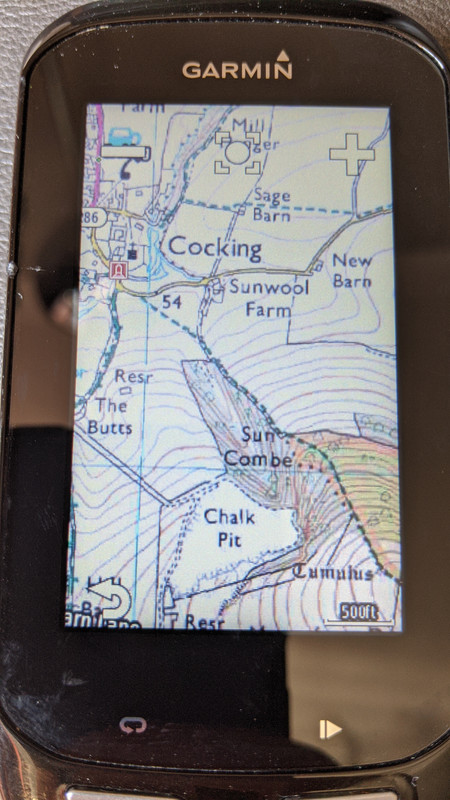 [/img]
Usually my Lezyne Super GPS works great including auto re-routing, albeit it doesn't do staggered junctions well at all.
However, I was reminded on Saturday about the negatives, as a consequence of no Three mobile reception on the Mendips plateau and then poor reception heading south west from Cheddar... The navigation went nuts and I had to stop every few mins to grab my mobile out of my back pocket to get my bearings, having saved a big area on Google Maps offline (which then only gives basic navigation for cars and not bikes).
Fortunately, i was only ~13 miles from base and decent reception plus navigation resumed after a few miles, otherwise it would a pain in the backside.
On my way back from Rodney Stoke yesterday, a chap I met combined his Garmin for recording with his iPhone(?) in a bar mounted quadlock for navigation.
musta been an issue with the Touring
Yeah it had a small low res screen, for sure. But maybe I'd bought the 50k maps rather than 25k? I don't remember now.
Edge switches between the 50K & 25K pretty seamlessly when you zoom (Just wish I could remember where the hell I got the mapping from!!)
Got the OPENGB maps from the-thorns.org - heres a screenshot to compare with OS above. Similar area.
The contour lines are a bit too bold, but apart from that looks nice, should be easy to follow.
[img] 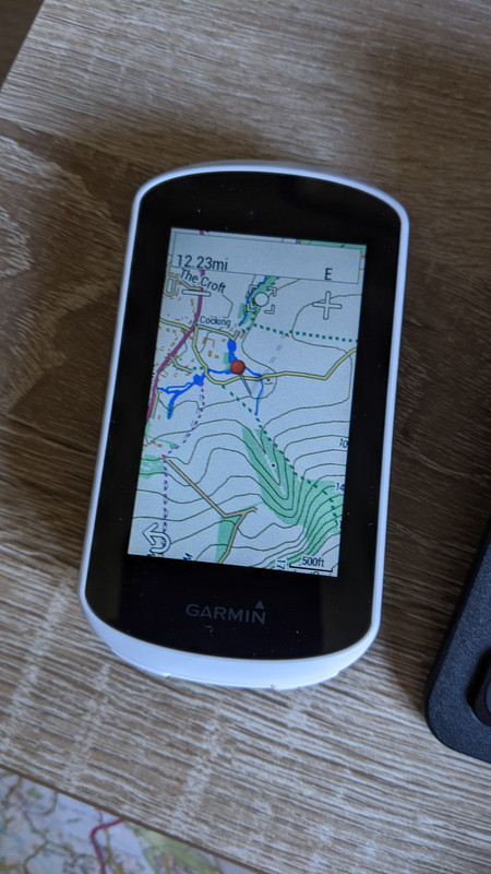 [/img]
This seems to be the Garmin way to buy OS (style?) area mapping - https://buy.garmin.com/en-GB/GB/p/86339#overview 3000km2 for £20