![]() You don't need to be an 'investor' to invest in Singletrack: 6 days left: 95% of target - Find out more
You don't need to be an 'investor' to invest in Singletrack: 6 days left: 95% of target - Find out more
A GPS uses signals from satellites to calculate its position on a sphere* (the earth).
If the satellites are orbiting the earth, the position must be worked out in 3D, not just 2D like triangulation.
So, why can't a GPS work out altitude above the base line of the sphere as well as position on the sphere ? Why do GPSs always use barometric pressure to estimate altitude ?
*Yes, I know it's not really a sphere, but it's very close.
AFAIK GPS can work out altitude, just not that accurately - generally within 20m or so.
But they do.
[i]But they do. [/i]
I thought they had to be used in conjunction with a topographical map to give altitude accurately without barometric pressure?
A GPS uses signals from satellites to calculate its position on a sphere* (the earth).
The earth is flat and everyone knows this.
They do calculate altitude, but need to fix on more satellites to do so than the minimum required for fixing a position in 2 dimensions.
They [i]can[/i] work out altitude from satellite signal - but it is harder to do and they require more clear signals than a small handheld will usually pick up.
I believe the error is usually ~1.5 times the horizontal error.
I thought they had to be used in conjunction with a topographical map to give altitude accurately without barometric pressure?
My Garmin 305 Edge doesn't use maps and magically it can give the altitude.
My somewhat ancient £10 Garmin eTrex (no base maps, black and white) works out altitude.
[i]My Garmin 305 Edge doesn't use maps and magically it can give the altitude. [/i]
I think the 305 has a barometric altimeter. But I may be wrong.
Drac - Moderator - Quote
I thought they had to be used in conjunction with a topographical map to give altitude accurately without barometric pressure?
My Garmin 305 Edge doesn't use maps and magically it can give the altitude.POSTED 18 MINUTES AGO # REPORT-POST
matt_outandabout - Member - Quote
My somewhat ancient £10 Garmin eTrex (no base maps, black and white) works out altitude.
But what altitude does it give? Jut because there is a number doesn't make it right.
I used to have an old (and heavy!!) Garmin GPS 12. That had no barometric altimeter or maps or anything other than a GPS receiver. It could happily work out altitude.
Wasn't very accurate, though...
Rachel
It is close enough. Like any GPS, you cannot trust readings of location or height beyond about 20m or so.
A barometric altimeter can be out as the pressure varies.
A map only has 10m contours.
None are perfect.
Trig via several good signals.
Barometric needs calibrating. Not exactly difficult to do, but just a tiny faff before you set off. Then it'll vary by <10m per ride IME (maybe unless there's a huge weather change mid ride).
Map look up can be very inaccurate in some cases (eg traversing the side of a hill, or riding a cliff top).
GPS determined altitude can be anything from acceptable for an endomondo ride to utter rubbish. Yesterday I rode along the highstreet of a village, and through 1-2km of farm fields. GPS determined altitude had me descending to 281m below sea level. Barometric (not checked yet) probably has me riding no more than +/-5m up/down. And my phone has a permanent vertical offset compared to a map.
GPS fixes are generated in the receiver by measuring the time taken for a radio signal to be received from a satellite.
To create a 2D fix (terrestrial) a minimum of 3 satellites must be visible. More accurate fixes are achieved by having more satellites in line if sight of the receiver. Fixes in deep valleys are less accurate or unacheivable for this reason. Conversely, on hills or plains fixes are more accurate. Terrestrial GPS receivers can give an altitude based solely on GPS, but generally not accurate because they are optimised to operate to a Datum (which, yes, is a flat but spherical surface).
Aero GPS receivers are optimised for giving accurate 3D positional fixes, and are very accurate. Their position algorithm use more satellites to create a fix. By a lucky quirk, more satellites are visible from the air..
Also terrestrial GPS can give more accurate altitude if they have a firm datum for generating that fix. Differential GPS being one example.
Hope that helps...
Read this thread:
http://singletrackmag.com/forum/topic/gps-elevation-accuracy-vs-barometric-good-references
Footflaps explains the issue quite well:
footflaps - MemberThe timing error is the same, the issue is the geometry which magnifies the error much more in the vertical plane as the difference in heights between the satelites relative to the user is much smaller than the difference in the horizontal plane.
That is the main issue which causes 'wobble' in the signal - i.e. when you are standing still the alt varies. There are other issues, such as the shape of the Earth not exactly fitting the obtuse spheroid it is sometimes modeled as.
GPS can work out altitude, but because it's referenced to a mathematical model of the earth it can't, by definition, be accurate anywhere.
The best way to do it is a barometric altimeter calibrated to a known reference point, as the Garmin Edge series of devices do, for example. Aeroplanes can fly with reference to GPS altitude in extremis, but it is only available as a rough guide and is only considered accurate to the nearest hundred feet.
But what altitude does it give? Jut because there is a number doesn't make it right.
Of course it doesn't.
Part of the problem is that a 10mm error in height is worse than a 10mm error in position, for many situations.
Differential GPS being one example.
I thought that was switched off (or at least people stopped buying into it) when the Ammericans stopped scrabling the GPS signals?
History lesson as to why GPS is now so much more popular than it was 10 years ago, the USA used to add a deliberate error to the signals so that your position could only be known withing +/- 50m or so. Which was fine for shipping in the middle of the ocean, but less usefull for armies.
There were 2 ways arroud it, a) make friends with Uncle Sam and get the code's to decifer the GPS signals accurately. b) buy a dGPS (differential) set. These worked by a signal on the coast (as most users were on boats) which knew it's position, figures out the error in the signal and broadcaast this to dGPS sets.
About 10 years ago the European Space Agency was going to launch a competitor to GPS without scrambling, the Americans didn't like this as they'd lose control of it so swithed off the scrabling, removing the need for an ESA version, but maintaining their ability to turn it off to various parts of the world. Since they turned off the scrambling there's very little if any difference in accuracy between them.
GPS can work out altitude, but because it's referenced to a mathematical model of the earth it can't, by definition, be accurate anywhere.
Actualy it can, burried in the settings you can pick a map projection (even without a map installed), this is what local maps are drawn in and gives the closest aproximation of a sphere for wherever you are in the world. So as long as you've got the right one selected then (within the accuracy of the signals/calculations) the altitude should be accurate.
IME the GPS claculated total climbing on my edge 305 was bang on when you count contours on a OS map. The barrometric one on my 800 seems to get confused by the weather (gaining/loseing a few hundred feet over a ride) and doesn't pick up small hills. And STRAVA's topo maps are even worse.
It's a combination of the poor satellite geometry for determining altitude and the fact that we are far more sensitive to distance in the vertical plane than the horizontal plane: 1,000m is not a lot of riding but it's a good amount of climbing.
The Garmin units with a barometric altimeter use GPS to calibrate. This is why your altitude will often drift during the first 20 min of a ride, although you can program a point of reference and if you are near that when you press start it'll immediately calibrate to that point.
I once did a 10x1mile lap time trial on a summers morning just after a huge rainstorm. My GPS, using its barometric alitimeter, told me I had been steadily descending for 1000 feet. - presumably the air pressure was low, then got higher?
And whenever i go for a ride with the same start/finsh point, the total ascent never matches the total descent.
Its a good think accurate altitute istn't really safety critical on a bike!
My 310XT can tell the altitude, but I'm not sure how accurately. It does pop up a little icon telling me it has 3D fix though and, to be honest, I'm not too fussed about small changes.
I did do some research into the way that GPS in general models altitude and tracks, but for the life of me I can't remember what I found out. I seem to recall the Ordnance Survey wrote some good material if you are interested.
I once did a 10x1mile lap time trial on a summers morning just after a huge rainstorm. My GPS, using its barometric alitimeter, told me I had been steadily descending for 1000 feet. - presumably the air pressure was low, then got higher?
Most likely the air pressure was significantly lower than when you last went for a ride and the GPS was calibrating the altimeter throughout most of your ride. Try leaving the GPS turned on and stationary for 20 min before starting your ride and you should find that it'll do a much better job. You can also program the altitude for your start point and it'll pick it up immediately. I find that my ascent an decent usually match very well if I do either of these, even over a full day's riding.
But what altitude does it give? Jut because there is a number doesn't make it right.
I've flown gliders (a lot) and often do glide calculations based on my gps given height (although I do have a barometric altimeter in the cockpit as well). After several hours flying, the gps height is the one i trust more, although both will be slightly out, but not enough to worry about.
So in conclusion, the GPS will give height as well, as long as the software is configured to tell you it, and there is a decent reception on multiple (3+) satellites.
Thanks for the replies, I think I've got the gist of it now.
Thinking about this now, in relation to my triangulation question, if the GPS device is using distance, not angle, to the satellites, then satellites near the horizon will be best for location and satellites overhead will be best for altitude.
I guess there are more satellites lower in the sky at any time, so horizontal accuracy will always be better than vertical.
It's all slightly complicated by the shape of the world being an oblate spheroid instead of a sphere.
May Garmin 500 gives me altitude
Unfortunately it's normally wrong , or else I do live bout 10 metres below sea level ...
I once did a 10x1mile lap time trial on a summers morning just after a huge rainstorm. My GPS, using its barometric alitimeter, told me I had been steadily descending for 1000 feet. - presumably the air pressure was low, then got higher?
Although pressure will rise after a cold front goes through, 1000' of difference equates to over 30mb of pressure change, so that isn't going to be the reason for the GPS reading.
May Garmin 500 gives me altitude
Unfortunately it's normally wrong , or else I do live bout 10 metres below sea level ...
should be pretty good, the edge 500 has a barometric altimeter in...
The barometric altimeter is very good for changes in height, but no good for absolute height because air pressure changes over time, which is why you need the GPS or some other method to calibrate it.
I've flown gliders (a lot) and often do glide calculations based on my gps given height (although I do have a barometric altimeter in the cockpit as well). After several hours flying, the gps height is the one i trust more, although both will be slightly out, but not enough to worry about.
So in conclusion, the GPS will give height as well, as long as the software is configured to tell you it, and there is a decent reception on multiple (3+) satellites.
GPS in a glider is more likely to have a strong signal due to a good view of the sky and the lack of tree cover, steep sided valleys (hopefully) 😆
Edge 500 allows you to set elevation points near your home, so you can tell it what the exact altitude of your home is...it then has a reference points against which to do all the barometric and gps altitude calculations.
works like a treat
easy.
Garmin 705/800 users (and probably 500 to) If you tend to start your rides from the same place eg home you can set the elevation of that point and as long as you're within 40ft or so the elevation will reset to that value when you press Start.
See page 27 Edge 800 owners manual.
I once did a 10x1mile lap time trial on a summers morning just after a huge rainstorm. My GPS, using its barometric alitimeter, told me I had been steadily descending for 1000 feet. - presumably the air pressure was low, then got higher?
I used to suffer a similar thing with my 705 on wet rides, turned out it was water blocking the barometric sensor holes, putting a plastic bag over the GPS cured the problem but made the screen hard to see. 🙄
the rubber case thingy for the 800 seems to stop the problem but makes the alarms hard to hear.
The iPad doesn't have barometric, but its GPS is fairly accurate. This is a screen grab I've just taken using UK Map, with OS mapping centered on where I live. The nearest main contour is 60m, about 196.8ft, and the GPS is showing 193/196ft, with a +/-16ft error:
[IMG] 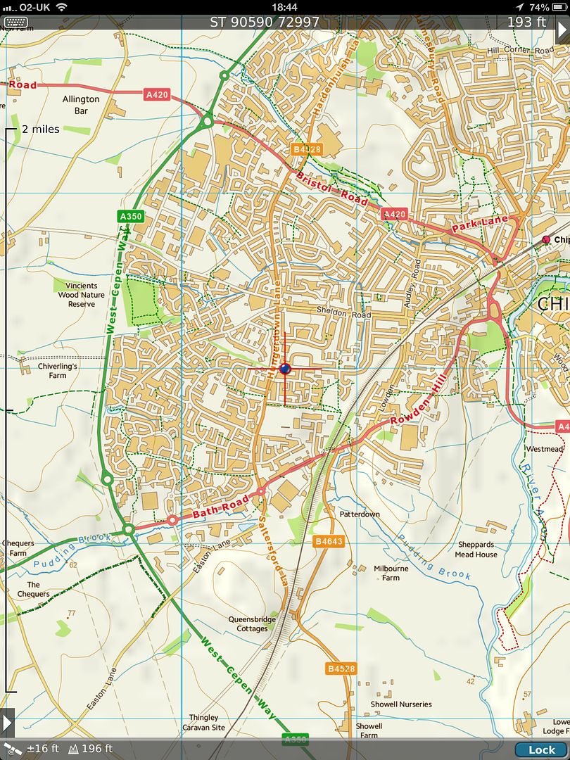 [/IMG]
Very good gps tutorial here that will answer a lot of questions - [url= http://www.trimble.com/gps_tutorial/ ]http://www.trimble.com/gps_tutorial[/url]/
As a land surveyor, GPS equipment gets its position by timing signals from itself to a number of satellites,. GPS (US ones) or GLONASS (Russian ones). Your car sat nave does the same, but probably not the GLONASS bit.
To get an accurate fix, atmospheric conditions must be taken into account. With my Leica Smart Rover equipment, ( RRP £20,000) I also need to pay for a smart net licence that is IRO £2,000 PA.
This dials into the smart net network via a mobile phone to a series of base stations to enable it to gain accuracy of between 10-15mm. If you have no GPRS phone signal, forget it.
I have other GPS equipment that is only 4m accurate unless its sited over known stations with GPS coordinates. This is essentially your car or bike sat nav but I have 2 that interact by radio with one another to gain fix. Their E an N are still only accurate to 3 or 4m and elevation to 5 or 6 m ( due to atmospheric conditions ) unless told where the base is, either by correction, eg set up, survey, manipulate on drawings like CAD, apply adjustments or as above with a smartnest licence. Or with a previous survey E.g, set up base, apply coordinated, survey knowing you are effectively inaccurate, apply adjustments on the computer later to gain true OS coordinates of base station location and carry on with survey.
My base and rover kit costs over £20,000 new. My Leice kit, similar plus the licence, paid annually.
What do you expect for a few hundred quid from your bike GPS?
Elevation is the hardest to get accurate BTW, E and N, 3-4m generally.
I thought I'd do a little experiment yesterday, while I was down at Brean, and check my phone's GPS against the trig point on Brean Down. I took two screen-grabs, one with Viewranger, because it has the proper OS mapping, but doesn't show altitude, and one using UK Map, which shows altitude, but the mapping is more basic free OS.
[IMG] 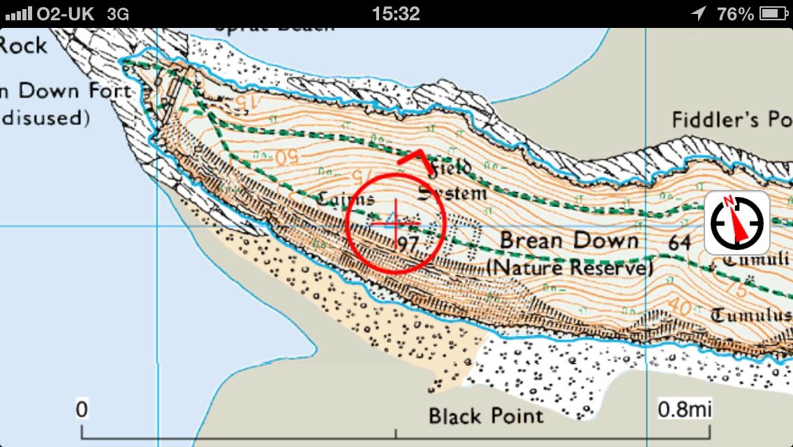 [/IMG]
[IMG] 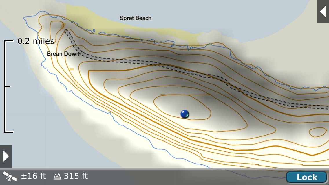 [/IMG]
The trig point is 97m, or 318.24ft, and my phone shows it at 315ft, after it had settled down and aquired enough satellites. Accurate enough for most people, I would think.
Count: pretty good for a fixed position but my experience is that Total Ascent/Descent on a route, as recorded by Endomondo, is often waaaaaaay of the mark.
Incidentally, does anyone know if there is some standard way to work out Total Ascent/Descent?
Obviously it is the total of every up/down but at what sort of distance/time resolution?
i.e. the ground is never totally flat, but at what resolution does/should it count towards total ascent/descent?
For example, crossing a road could add 20cm to ascent and descent for the kerbs, plus another say 50cm for going up and down the road camber, but presumably it normally doesn't (partly because the GPS isn't precise enough to detect it).
Looked at that before (ye olde worlde thread on here).
Everytrail iirc was one that simply added the +/- differences between every consecutive data point in the file. Data points were typically at 1s intervals, but several may be missing due to bad lock, etc.
Endomondo iirc smoothed it a bit.
Strava invented some extra relative height differences from somewhere else.
edit: not sure what the eTrex does - think it might be just the sum like Everytrail uses.
The exact same file was used for all 3.
Those spot checks seem pretty accurate, certainly accurate enough. Mine gives a reasonably consistent +40m offset.
Can anyone explain why my last endomondo trip decided my altitude dropped to 281m below sea level? The only descent I did was off a bridge crossing the railway about halfway thru a ride. (can sort pic later).
Endo can be all over the place. I record my commute and always take the same route and my Total Ascent varies between 100 and 300m!
And if you try importing a GPX from a Garmin then you can get some very odd figures (mate had one where it looked like it was reporting the ascent in feet as if they were metres - resulting in an ascent three times higher than it should have been.
Reported it to Endo Support and they just said they knew there were "some inaccuracies" 🙄
I fly hot air balloons for a living and use a GPS iPad and an altimeter/variometer. The altimeter/variometer uses barometric pressure and is by far the most accurate. If you can find a GPS that fits your needs and has a barometric sensor then your in business.
I'll certainly concede that altitude lost/gained may well be open to all sorts of cumulative errors while the device, whatever it is, tries to maintain its contact with the satellites. It's different to standing in one spot while the device settles down. Putting barometric sensors into phones/pads would be a useful addition, seeing as how they're being used more and more for outdoor pursuits where accuracy is needed.