![]() You don't need to be an 'investor' to invest in Singletrack: 6 days left: 95% of target - Find out more
You don't need to be an 'investor' to invest in Singletrack: 6 days left: 95% of target - Find out more
A short, simple question, although there are variations, such as; within Great Britain, within the British Isles or entirely across land.
I've heard it's possible to see England, Wales, Scotland and Ireland from the Isle Of Mann, so I'm guessing one of those could be the longest distance across the sea.
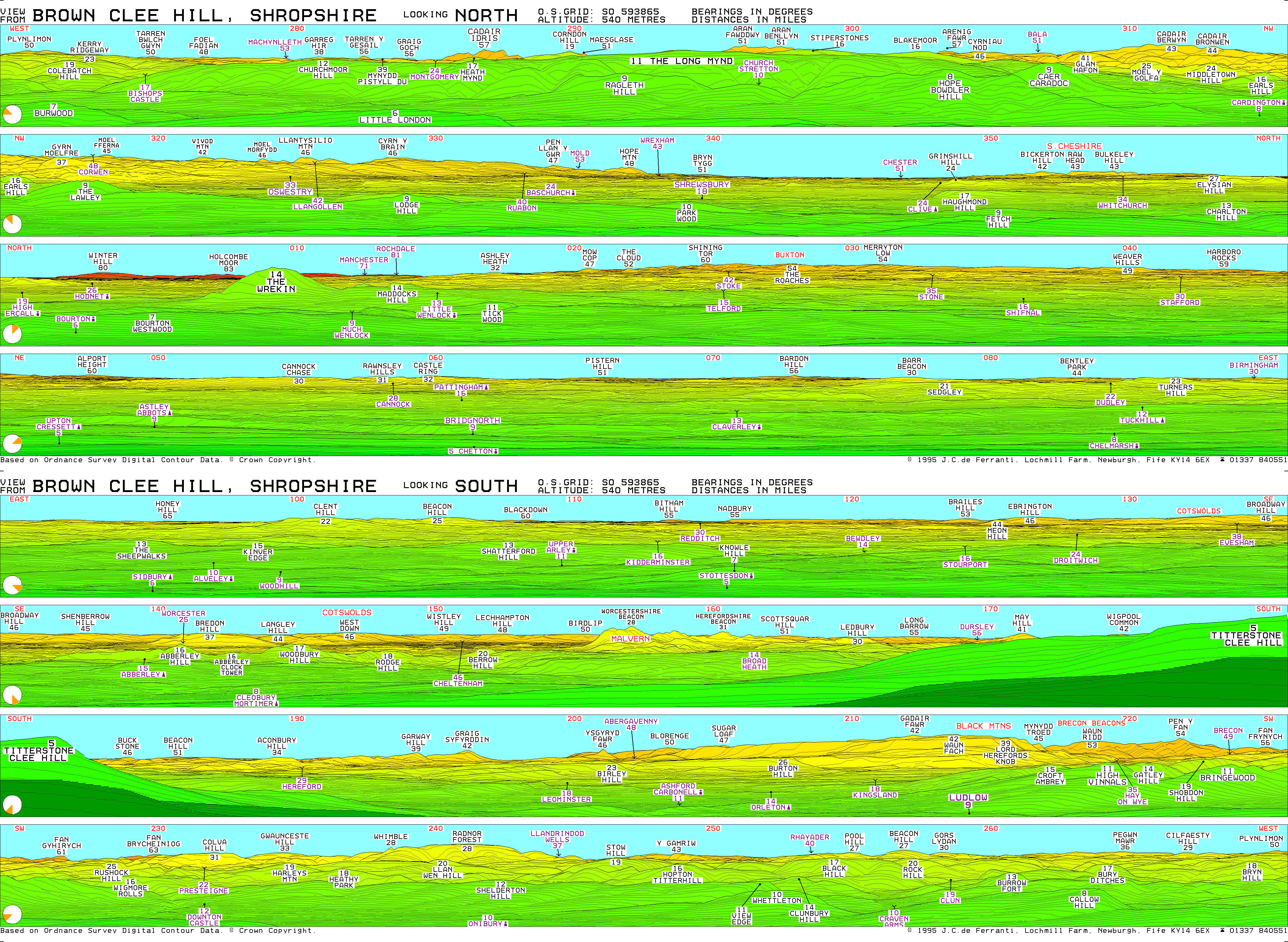
The Peak district is visible from Clee Hill, which is about 75 miles away across land.
Any advances on 75 miles?
Going outside the UK, I've also heard that Norway is visible from the Cairngorms.
Going outside the UK, I've also heard that Norway is visible from the Cairngorms.
I'd be surprised, it's 400km and the distance to horizon from 1200m (Cairngorm Plateau) is only 120km...
In fact, earth curvature would scupper it: http://www.davidsenesac.com/Information/line_of_sight.html
I'd hazard a guess that going up Ben Nevis or Snowdon's going to give you your answer. Or emley moor mast
vaguely related
I **think** from childhood memory max lighthouse visibility is up toish 28 miles.
*and height makes a difference (lighthouse 110ish feet)
You can see the New Forest (pretentious Nimbyland) from Totton (Pikeyville just outside Southampton). They're pretty far apart.
The furthest I have personally seen is around 100 miles clearly to Snowdonia from Coniston Old Man. This site suggests I could have seen much further from other Lake District hills on the right day.
http://www.viewfinderpanoramas.org/panoramas.html
That must be beatable somewhere in Scotland.
From the site above:
"The longest theoretical line of sight in the British Isles is 144 miles (232 km) from Merrick, in the southern uplands of Scotland, to Snowdon in North Wales."
Would need quite a day, though.
[url= http://www.cactus2000.de/uk/unit/masshor.shtml ]Visible horizon calculator[/url]
It's quite simple geometry really.
So from the top of Everest you could theoretically see 208 miles. Fun fact.
Irrelevant in this context, as I don't think Everest is in the UK, or Great Britain or anything similar.
Makes sense that the higher up you are, the further you can see. From Cairngorm on a cold, crisp winter day it's possible to see Morven in Caithness, Torridon and beyond Ben Nevis. I've also seen Jura from the Pentlands just outside Edinburgh. I'll get a map later and work out some distances.
Makes sense that the higher up you are, the further you can see
And the higher the object you're looking at, obviously.
The Peak district is visible from Clee Hill
I'm a little sceptical tbh. The Brecon Beacons are only just visible, Pen y Fan is about 80km from Clee Hill village.
I've seen the IoM from Snowdon, I think, and I also think I have seen Northern Ireland but not quite sure.
EDIT actually looking at the map, must've been Wicklow Mtns which are about 150km but not in the UK of course so disqualified.
I'm a little sceptical tbh. The Brecon Beacons are only just visible, Pen y Fan is about 80km from Clee Hill village.
Seems marginal - you'd certainly need to know where to look.
Footflaps, I think a superior image was the reason. A bit like a mirage, except that instead of the light bending upwards and looking like a reflection, it bends downwards, effectively allowing you to see beyond the horizon.
I also think I saw the Lake District from Snowdon (it was a ludicrously clear evening and a sight I'll never forget) which is 160km away.
I reckon I saw most of Wales that day, you could clearly see Cardigan Bay curving around to the South. The perspective looked a little distorted so perhaps the superior image thing was a possibility. It was at dusk with snow on the ground, clear skies and temperatures dropping fast.
If I could be bothered I could do an analysis in GIS software to test the above, but I can't. As well as the curvature of the earth you have to consider atmospheric refraction using an assumed refraction coefficient.
Molgrips, I can't remember the proper name for it, but there's one of those brass maps on a stone pillar on the top of Brown Clee Hill with all the distant land marks on it.
I've never been up there on a clear enough day myself, but I'm sure it says you can see the peak district.
From my local trails in Ayrshire, on a clear day Northern Ireland and the mull of Galloway is visible to the south, as is Ben Lomond to the north.
Lake District from Snowdon quite a few times
And the hills in Eire esp when covered in snow
70 miles or so
So from the top of Everest you could theoretically see 208 miles. Fun fact.
If the surrounding land was at sea level. Though you could in theory see the top of another mountain the same height (bear with me, this is just theory) 416 miles away if the land went down to sea level in between.
On refraction etc

I'd agree with martinhutch, the Merrick would be a contender for the farthest view, as there ain't much to the south for miles, and again, the southern highlands around Loch Lomond are visible to the north.
Logically, Lakes from Snowdon should be the furthest - two of the highest points that are both close to the sea so nothing in between.
Went up Cairngorm one day and saw lots of other hill really really far away as it was a clear day. No idea what any of them were called.
Useless post really.
I'm a little sceptical tbh. The Brecon Beacons are only just visible, Pen y Fan is about 80km from Clee Hill village.
Seems marginal - you'd certainly need to know where to look.
Knowing the geography of S Wales pretty well, it's very obvious. Small, but obvious. And it has to be pretty clear of course.
I'd hazard a guess at Ben More on the Isle of Mull or The Cuillins on Skye. Big old hills with plenty of sea around. Possible to see a long way from the top of either in good conditions, and to see them from a long way away.
Black mountains from Clent is perhaps the furthest I've seen
Knowing the geography of S Wales pretty well, it's very obvious. Small, but obvious. And it has to be pretty clear of course.
I meant the Roaches in Staffordshire, not PenyFan. A bit more of a challenge.
Galloway from
Snowdon? Around 140 miles
Oh yeah, absolutely 🙂
tomd - Member
I'd hazard a guess at Ben More on the Isle of Mull or The Cuillins on Skye. Big old hills with plenty of sea around. Possible to see a long way from the top of either in good conditions, and to see them from a long way away.
Aye that was my kinda thinking, possibly goatfell on arran could be a good shout aswell maybe, dunno if you'd pick up any of the welsh hills from there(I shat it to go to the top! 😆 ) or how far north you'd get up the west coast.
I can see into your bedroom window from here, ok so I need some binoculars but still a nice view. 😯
With or without binoculars/telescope?
British Isles The longest theoretical line of sight in the British Isles is 144 miles (232 km) from Merrick, in the southern uplands of Scotland, to Snowdon in North Wales. I have found no longer sightlines, and none were found in a study by topographic researcher Chris Jesty in the 1980's. A 1990's Guinness Book of Records published this superlative, but gave the distance as 144 km (sic)....... Merrick would be practically impossible to observe from Snowdon, because of the very thin aperture it shows behind nearby Lamachan hill. To give an analogy: if a colleague and I were in neighbouring rooms, and I were at a desk but the colleague were looking through an empty keyhole, he would probably see my clearly, but I would not see him. The "keyhole" is Lamachan Hill, which is much closer to Merrick, so an observer on Merrick would see Snowdon much more easily than vice versa. Infact, Merrick would be impossible to observe from Snowdon other than with a telescope, and then only if there were a suitable contrast with Lamachan Hill (e.g. snow or sun on one but not the other) That is why Merrick is not shown on the Snowdon panorama.
From [url= http://boards.fool.co.uk/longest-lines-of-sight-11860853.aspx ]this forum[/url]
I'd hazard a guess at Ben More on the Isle of Mull or The Cuillins on Skye. Big old hills with plenty of sea around.
Yes but looking at the map, there are nearby hills that would obscure the view of anything further away.
The mountains on Harris from the top of Hirta?
You can see Porthcawl from Ilfracombe and it's about a 250 mile drive, if you don't use the Severn bridge.
EDIT - Oops sorry P-Jay, I missed that you'd already done that one!
The mountains on Harris from the top of Hirta?
Only 100km by Google.
I think there is a faint possibility of standing on Worcestershire Beacon (Malvern Hills) of spying Dunkery Beacon in Exmoor (with visual aid, in particular conditions)
No. 10 Downing street, everything outside the gates.
@wml - that post was on my mind -- I've been up Cuillins on a very cold, clear day - we reckoned the smudge on the horizon would be - possibly - St Kilda...
P-Jay is Stacey from Barry, and I claim my £5!
I've been up Cuillins on a very cold, clear day - we reckoned the smudge on the horizon would be - possibly - St Kilda.
Almost 150km and you'd have to look right through the gap between North Uist and Benbecula.
No you wouldnt - North Uist and Benbecula are low level.
As long as you can see the sea on the other side of them of course, then it'd be a possibility. Could be handy for verification actually.
[img]  [/img]
good work scotroutes!! (needed to zoom my browser like mad for that one..)
This was ages ago, pre 1990 I think, well before any such tools were easily available.
needed to zoom my browser like mad for that one..
<open image in new tab>
<click on +>
I'd like an app for my phone so I could hold it up and see what I'm looking at in the distance. (Like Google Sky Map, but for the ground). On lovely clear days on Cannock Chase I'm sure you can see Jodrell Ban.
I'd like an app for my phone so I could hold it up and see what I'm looking at in the distance.
I actually wrote an app that did this a few years ago while at Uni. It was a little rough around the edges but worked. Unfortunately I didn't find the time to polish it up and publish it. Maybe I'll go off and re-write it.
Pekas.AR or similar, isn't it?
PeakFinder app does this. There are various different regions available. About £2 I think.
If you go up Sneddon Law in Ayrshire you can see Moscow!
Fact!
Blackpool Tower from Todmorden's a good spot, given the usual level of grot in the air.
You can see it from Pendle Hill on a good day, but not managed it yet.
Must be able to see the Lakes/Northumberland from Theively Pike too?
I'll have a play later.
You can see Benny Hill from the Pennine Bridleway btw.
That [url= http://www.viewfinderpanoramas.org/panoramas.html ]panorama [/url]website is pretty cool/nerdy
I've seen Benny Hill and I was in Edinburgh.
I reckon if I stood in the right place in [url= http://www.theguardian.com/science/2014/feb/01/diamond-britain-large-hadron-collider-particle-accelerator ]here[/url] I could see, well, forever 😀
[img] 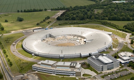 [/img]
Great website. One day last year I could make out the Wrekin from Rivi pike which is 66 miles acording to that site.
I've seen the Cheviots from Lochnagar - 111 miles apparently.
Nice to get confirmation that Ailsa Craig is indeed visible from Ben Lomond!
I've ridden London (well Greater London) to Brighton off-road a number of times and it's quite daunting being on Winterfold (Surrey Hills) and looking to the horizon to see the South Downs and the sea and thinking "Jaysus, we've got a long way to go"
I've seen both Snowdon and The Isle of Arran from the top of Slieve Donard - each more than 100 miles away.
Actually, makes me wonder what are the two furthest apart places in the UK which can be seen from a single location (also in the UK). Arran and Snowdon must be in with a chance on that?
ETA Fairly sure you can see Sacfell Pike from Slieve Donard as well, which is also over 100 miles away. It's quite a view!
I've seen the Cheviots from Lochnagar - 111 miles apparently.
I've almost done the reverse on a few occasions. From the summit of the Cheviot up to the tops of Angus, Mount Keen and Glenshee, over west towards what I thought must be Ben Lomond and Lawers area, and south down the coast to Yorkshire and SW to the Lakes. I'd been told that you should theoretically be able to see Ben Macdui but [url= http://www.udeuschle.selfhost.pro/panoramas/makepanoramas_en.htm ]this (other) cool panorama generator[/url] suggests that would instead be Braeriach - though good luck making it out amongst the mass of hills. Cheviot is a good top for long views in several directions. According to that site the view theoretically extends 210km into the Cairngorms, 110km into the North Sea, 159km into the N York moors, and 143km down to the lakes, taking quite a bit of landscape in between.
Slieve Donard suggested above by PZ_Steve looks pretty good for distant views in all directions though - 212km to the SE, 197km to the N, 162km W, 193km E (in theory).
Also RE seeing Norway from the Cairngorms - impossible, but I've been on the top of Beinn Mheadhoin or Ben Avon IIRC and seen what looked like mountains "floating" in the distance to the east, seemingly way beyond anything else so understand where the idea might come from. Someone later suggested it could be a result of the inversion and diffraction of the light or some such, but I can't remember the specifics. Pretty wonderous stuff in any case.
Of no relevance to this thread whatsoever is this interesting (?) fact. If one were to fly off the eastern edge of the Black Mountains in South Wales in say a microlight and were to maintain your altitude (approx 2000 feet), and were to fly due east you would not, assuming an adequate supply of fuel, crash into another hill until well into the Ural mountains beyond Moscow.
Told you it was irrelevant 🙂