![]() You don't need to be an 'investor' to invest in Singletrack: 6 days left: 95% of target - Find out more
You don't need to be an 'investor' to invest in Singletrack: 6 days left: 95% of target - Find out more
Was he looking for the pub or just doing a survey? If so, for what? Shale bearing rock? Mapping? This was last night (Monday) at around 9.30.
[img]  [/img]
Just crusing the skys, looking for a hook up 😉
Isn't that one of the Ordnance Survey planes? Follow them on Twitter, they often post flight plans, pictures from the plane etc.
Looking at the terrain...
Lidar scan for a windfarm.
Environment Agency
https://environmentagency.blog.gov.uk/2014/08/04/high-flyers-tales-from-the-aerial-survey-team/
Googled the plane reg
Saw that fly over my house last night, went to put the rubbish out and heard the engines. Was fairly low as well.
Chem trails 🙂
There was also one over Shropshire late on yesterday
contrails.
I thought it might be something like that.
"Once the flying season is under way, it is all systems go to ensure LIDAR data is captured before the leaves return to the trees. This can often mean odd working hours including nights (LIDAR is a laser scanner and does not require daylight to work) to fit in with good weather conditions."
That's the worst attempt to draw a cock and balls with a flight path ever!
That's the worst attempt to draw a cock and balls with a flight path ever!
I reckon they were trying to draw the lower intestines.
Photographer?
Looking for killer laser unicorns. Thankless job.
There's a company who do similar things over London on nights in a light aircraft.
I spoke to an air traffic controller at work and they were saying that they do it to test and calibrate the navigation beacons and other things that pilots need to find their way to airports.
It'll be a while before he loses that kom
I have a friend who flies in the ordnance survey planes likes that too when they are mapping.
Probably photographing something.
Geomatics group do some splendid work, lidar is amazing, difficult to comprehend the detail that can be achieved, certain types can pick up power lines.
[url= https://twitter.com/EnvAgencyGeomat ]Geomatics twitter link[/url]
[img] 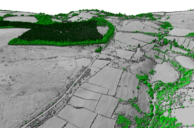 [/img]
And you'll be pleased to hear that it's now free to use under licence, maybe some use to budding trail builders... 8)