![]() You don't need to be an 'investor' to invest in Singletrack: 6 days left: 95% of target - Find out more
You don't need to be an 'investor' to invest in Singletrack: 6 days left: 95% of target - Find out more
98% farmland or natural (mostly the latter) 🙂
75% of Southampton. 👿
So glad I live in deserted Galloway, even a trip to dumfries sets my hackles on edge due to the traffic/amount of people
1% according to the map thingy
4%.
Not too shabby.
Built on 4%
Green urban 2%
Farmland 84%
Natural 10%
1% built on 🙂
City of Edinburgh
Built on35%
Green urban17%
Farmland37%
Natural11%
but this is very skewed by the way city of edinburgh council is actually much bigger than the city itself encompassing satellite towns and the green belt between the city and the satellite town. The city itself is very densely built on with little green area compared to many cities
Edit this is the pic they use. Most folk would think of the city as the bit inside the bypass mainly ie the dense red bit
[img] 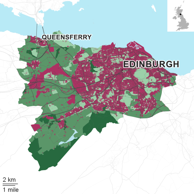 [/img]
3%
I'm assuming by natural, they include managed grouse moors....
96% Farmland (54)/ Natural(42)..in Northumberland...
I live within this category.
Built on land 2%.
69% built on, 21% green urban for bristol, and the boundary is mostly what I would consider the city. Happy with that. Green enough with plenty of facilities within a short walk or cycle. Not sure I want to live in a 1% area and have to drive everywhere.
4% built on
88 % farming
6% natural
The mendip hills , middle of Bristol as mentioned above is a 70 mile round trip by bike from home
Cardiff has the same skewed figures for the same reason as Edinburgh. In reality they're building everywhere they possibly can, mainly offices and posh student halls.
Really miss living in the countryside 🙁
Where I currently live: 69% (London so was actually expecting it to be higher)
Where I’m moving to: 7% 🙂
2% natural.
"St. Helens Council - F****** the environment for you, your children and your children's children"
50% natural
48% farmland
1% built on
1% green urban
some interesting facts on the BBC website today analysing this data.
http://www.bbc.co.uk/news/uk-41901297
I particularly like (paraphrasing) that the coverage of Britain by buildings is a lesser area than that uncovered when the tide goes out.
We do still generally live in a green (and pleasant?) land.
56% natural (forestry trail centres and hill farms/shooting estates type stuff windfarms? Reservoirs?)
4sonething farm land.
<1%built and urban green.
It's given all of the Scottish Borders so hard to tell.
Southern edge of the Yorkshire Dales (Craven)
Built on1%
Green urban < 1%
Farmland 41%
Natural 57%
Even a small town like Skipton feels noisy, crowded and claustrophobic. Rural lad at heart 😆
Some figure with at least 0.00 in front of it, I should think...
Farmland, well Strawberry Fields to be exact.
2% Northumberland really is shit.
No point in looking on mine - it changes every week.
Even the fields where I used to walk my dog are getting changed into a shitty industrial estate.
46% at the mo. That'll be easily 60% by 2019. No more roads though, oh no. Hmph.
Ha - funny - Portsmouth is 70%. But the only green bits are marsh and shoreland. I'm sure they'll find a way to build on that in a few years.
Sunny Brentwood on the edge of the M25
Built 10%
Green urban 8%
Farmland 76%
Natural 6%
You can be on country lanes within a couple of hundred yards of the High Street or into central London within 36mins (with crossrail next year)
It's a bit flat though with sadly no real vistas of any note.
The boundaries don't mean a lot though do they? For example the area I live in says 45% built on, but I'm on the edge of the conurbation. If I put say a 5km radius around my house it would be much more farmland and natural.
Cheshire West & Chester area, although stats are skewed by the frankly massive conurbation that is Chester and the post apocalyptic industrial wasteland that is Ellesmere Port (how the **** that is included is beyond me), we've got:
10% built on - see above
4% green urban - must be Grosvenor Park in Chester
81% farm land
5% natural - off set by the massive amounts of dairy farms in the area I'd imagine.
78% "natural"
[img][url= https://farm2.staticflickr.com/1647/24080008490_a6acf6f158_k.jp g" target="_blank">https://farm2.staticflickr.com/1647/24080008490_a6acf6f158_k.jp g"/> [/img][/url][url= https://flic.kr/p/CFSkAb ]Rescue 177 final flight[/url] by [url= https://www.flickr.com/photos/matt_outandabout/ ]Matt Robinson[/url], on Flickr[/img]
42% - not too bad for a London borough.
Heavily skewed by the two biggest Royal Parks though - 57% green urban...
Built on 10%
Green urban 6%
Farmland 49%
Natural 35%
Just on the edge of Farnham.
Figures given are for all of Highland Council so with a built up area of <1% it's fairly accurate for my area but not for Inverness
As above.
Natural 91, Farmland 8.
The boundaries don't mean a lot though do they? For example the area I live in says 45% built on, but I'm on the edge of the conurbation. If I put say a 5km radius around my house it would be much more farmland and natural.
The sample area is too big, I'm in Southwark so it's 75% but I'm literally the last few houses in the southern tip of the borough with a nature reserve opposite, Crystal Palace park over the way and Dulwich wood/park down the road so it's more like 50.
It's one of the reasons I moved here after living in a back to back terraced area.
I still think of London as a green city though, when I look out my bathroom window I can see right round from towards Heathrow, out to Wembley and across to the Shard at London Bridge and it's mostly treetops with buildings sticking out which a lot of other big cities don't have.
Doncaster
Built on 16%
Green urban 5%
Farmland 72%
Natural 8%
[img] 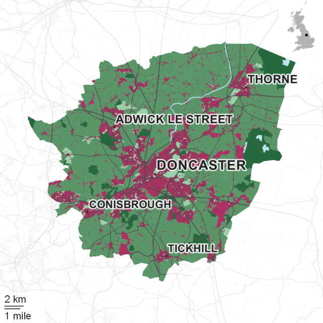 [/img]
Not sure how they are defining natural though. Doncaster seems more built up when you're moving around it but outside of the town centre it's mostly a collection of villages based on old manors and country seats, the ribbon development along the connecting roads fools you into thinking places are more built up than they are.
Built on - 57%
Green urban - 24%
Farmland - 17%
Natural - 2%
I live in a London borough right out in the suburbs, I don't think those figures are that bad...! I'm right on the edge of the proper greenbelt
Forgot to post the results for Galloway back on page 1
Built on 1% Green urban< 1% Farmland 40% Natural 58%
Only other place i've lived is Argyll
Built on< 1% Green urban< 1% Farmland 10% Natural 89%
^
I'm right on the edge of the proper greenbelt
Just thinking about living in such a place gives me the heebie-jeebies, I'm a very happy self confessed isolationist with an aversion for people 😀
Seems flawed as they don’t appear to include roads in their built on calcs
57% built on, but it never seems that much as we have access to much of the military training land, as opposed to farmland which looks OK but you don't tend to have much access to.
I'm a very happy self confessed isolationist with an aversion for people
You'd be fine living in London, unless you want to you could live at least 90% of your life without actually speaking to anyone. I reckon where you live there are people who'd go out of their way to come and chat to you...
Nope, not a chance - i need hills, trees, fresh air and the isolation that means i can ride for 6+hours/day without seeing another house or person, i had to venture south of the border (nr Birmingham) last December to collect my new van - genuinely did not like it at all - just felt so unnatural/unhealthy to be in such a heavily built up enviroment with so many pent up aggressive drivers and stacked housing estates blending into each other.
Derbyshire Dales - seems about right
Built on 3%, Green urban 2%, Farmland 81%, Natural 14%
Rural West Norfolk, classified as "Breckland"
Built on -3 %
Green Urban - 1%
Farmland - 81%
Natural - 15%
Surprised to be honest that the farmland is that low.
Slightly OT, but in some countryside places I actually found it hard to 'get out and explore' easily
Farmers fields look nice but they're not so great for exploring and the foot paths are as a result very limited or get diverted around the edges (in the places that I remember wandering around in) - I guess I'm particularly talking about flat arable land
Natural areas can 'look' as green from afar, but are much better for exploring
I live 3 miles from the centre of Leeds. Only 29%is built on apparently.
Bollocks. It they use more than the first two letters of the postcode it might provide a more accurate answer...
6% built, but we are in the process of having 10000 homes built right around my village. Post code covers a massive area though.
London Borough of Hillingdon
Built on 53%
Green urban 18%
Farmland 23%
Natural 6%
The surprising bit of that was 23% farmland in a London borough, thought it would have been in single figures.
London Borough of Hillingdon
Basically the countryside 😛
Same as JimW
Klunk - Member
Built on 4%
Green urban 2%
Farmland 84%
Natural 10%
Snap!
Nice to see looking at the map that I live on a 'built on' bit that is right next to pretty much the largest area of 'natural' in the local authority. Equally nice that the FC have built (and turn mostly a blind eye to us building and riding extra) some trails in that area.
Brighton and Hove
Built on - 40%
Green urban - 15%
Farmland - 43%
Natural - 1%
But I live just around the corner from a green urban space which gets me to the South Downs National Park in about five minutes on the bike. Can't complain!
Built on <1%
Country and/or farming 99%
Ceredigion region, Wales.
All of my flat is built on.
Less than 20% of the house is built on.
50% natural, 35% farm, but I live in the edge of city, it's a shame it's calculated by boundary, as that really skews the picture and does not really mean anything, and not a certain radius from a post code or whatever.
Not sure how they are defining natural though
A very broad definition given that there is very little natural land in the UK. the highlands? Nope - man made landscape etc etc
8% built on in a nice bit of Cheshire, with ace little market towns as the build up bits and lots of green around farmy stuff and natural, with good links for travel. Yeh not bad