![]() You don't need to be an 'investor' to invest in Singletrack: 6 days left: 95% of target - Find out more
You don't need to be an 'investor' to invest in Singletrack: 6 days left: 95% of target - Find out more
Anyone live nr Royal Leamington Spa or Long Itchington?
What's happened to the Lias Line and NCN 41 route round there? Is it ALL new continuous traffic-free path on the old railway line?
It's not appearing on Sustrans' own live mapping, but something's showing on OpenCycleMap.
Is it all built, rideable and connected-up, or is there a dead-end?
Need primary-source input!
TIA
It isn't yet joined up. The bridge over the Fosse that HS2 were supposed to build a couple of years ago still isn't there. You can take the Offchurch Greenway as far as the Fosse, cross the road and head along the old railway line and you will find the dead end of the new route about 100 metres from the road. The new route will then take you on a pleasant trip to the canal at Long Itchington.
Edit: just before you get to the Fosse, you have to cross the line of the HS2 works. There is a bloke in a little hut whose sole job is to let you across. Some days he gets as many as 6 people!
Yeah as above.
What's your plan?
I was walking along it from Long Itch yesterday. Any more info just ask.
When you cross the Fosse, the new paved section technically isn't open yet but people have pulled the security fence down and you can easily get past.
Instead of going on the paved bit, there's a cheeky little tekkers trail on the left if you like ducking under branches and fighting for flow with no gradient.
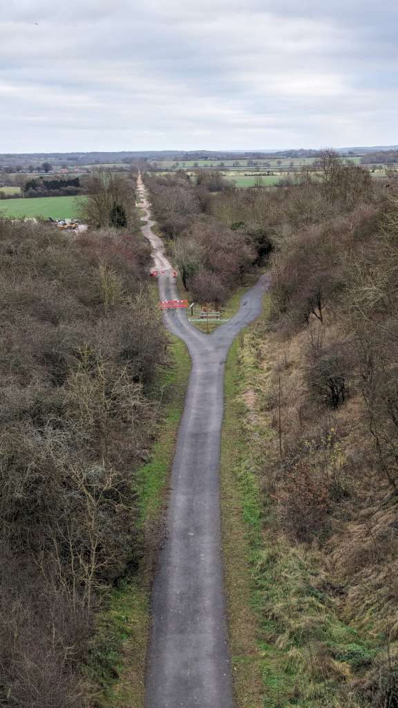
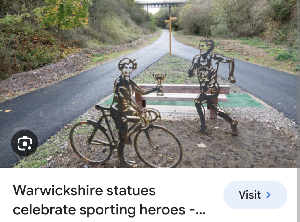
After the awesome metal Snowford bridge, it branches right to Long Itchington, straight on is to Rugby. They've stopped work in that direction shortly after but I think eventually it'll go all the way to Rugby, should you be so inclined to go to Rugby.
But yeah, the Long Itch way stops at the canal. You can get through still that way to Long Itch but at this time of year there is a section which gets horrendously flooded and full of the fly tipped junk from the farm above it. Not the best. Most people take the canal. Not sure if they plan to extend up there eventually or not but I hope so.

DM'd you both 🙂
As per my answer by DM.
Hi there
Yes I'd be very happy to help where I can. I cycle along there relatively frequently as I live nearby in Leamington.
The route was always 'cycleable' of a fashion but it was always rough gravel track AFTER the Fosseway. Before the Fosseway on the Leamington side, the Greenway has been surfaced for years. It starts at the Grand Union Canal at Radford Bottom Lock and goes to the Fosseway, with one road crossing.
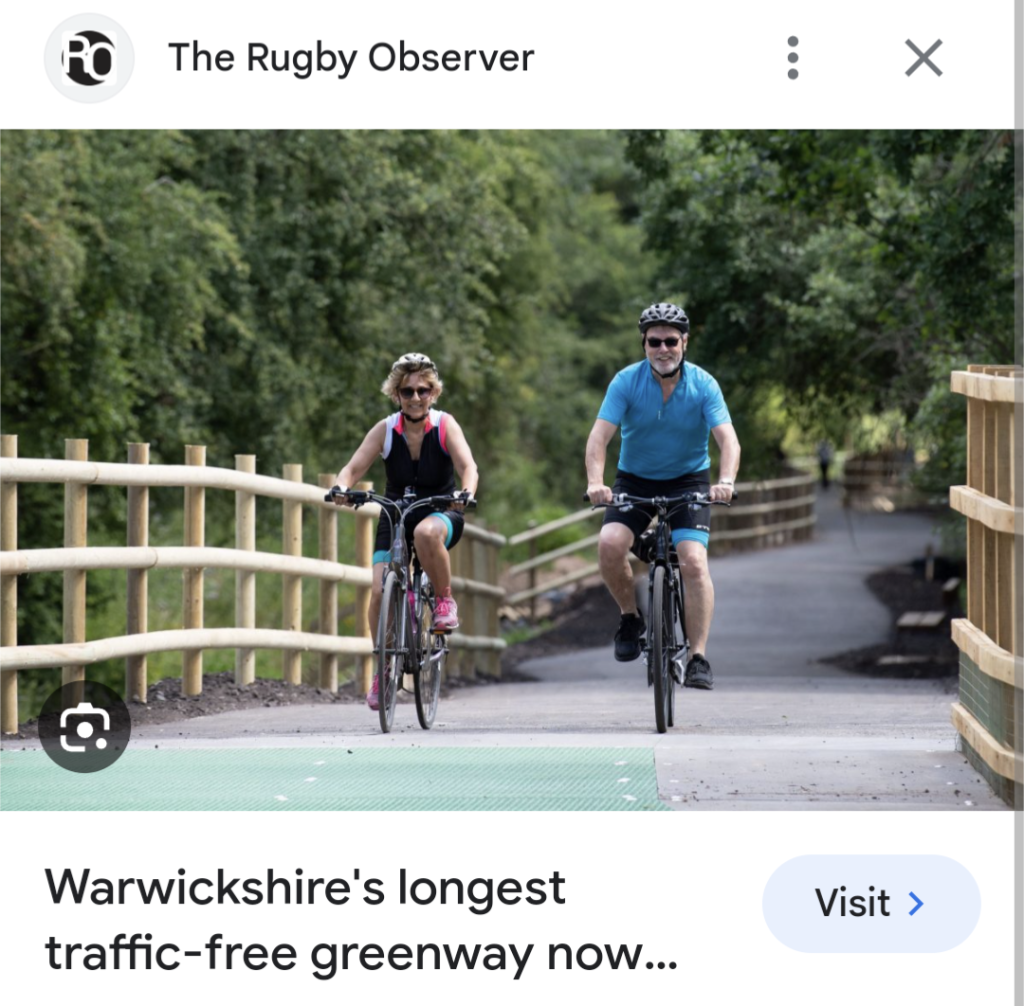
They have now surfaced the section after the Fosseway and built wooden platform bridges and nature corridors etc but it is yet to be officially open.
This is the newer surfaced section.
I believe that HS2, whose work compound is next to the Greenway are meant to be building a cycle bridge over the Fosseway at some point but as was said in the thread above, the line cuts across the Greenway and you now have to pass through the HS2 compound to carry on along the Greenway (although it wasn't still manned last time i was there, and you could pass through freely, albeit with an annoying diversion)
After you cross the Fosseway, there is about 100m of rough ground before the surfaced bit starts. I'm thinking that eventually the bridge will link up to this bit. There is quite a dip in the landscape here where the Fosseway is so I guess the bridge will.... bridge that dip eventually.
The surfaced section starts there. It's tarmac and double width with wooden fences alongside and low platform bridges on swampy bits.
It goes under Snowford bridge in about 300m and 50m after that is the fork. Straight on to Rugby, right to Long Itchington.
There is a metal bench there with two metal sculptures by it. Not sculptures as such but cnc cut metal portraits of(if i remember rightly) two local Olympians, one a runner , one a cyclist. I'm not sure if those are the portrait benches you are referring to?
As I say, the tarmac surfaced trail carries on maybe 500m more towards Rugby but then stops being surfaced with roadworks barriers.
The trail still carries on essentially but it is unsurfaced.
If you take the right fork to Long Itchington, the surfaced path (again, nice and wide like a road) it ends when it reaches the Grand Union Canal and I believe the signposts for the National Cycle route then point you up the canal as the national cycle route.
Let me know if there is anything else you need. I go up there now and again with the dog so very happy to provide photos or anything else you need.

I explored both the open and not open bits of the Lias Line a year ago

https://strava.app.link/WHGj4RpvrFb
In addition to what Kayak said, although is no access from the Fosse, they have built access points wherever the line crosses a road, so you can make a route. Also NCN41 has a reasonable crossing of the Fosse at the roundabout just south of where the line will eventually cross. The official route then continues on road until it meets the new Lias Line.
I was surprised to see the start of works towards Rugby from the junction with the sculptures, as I've tried to navigate that route and it is impassable in two places - one where a bridge over the A423 has been removed, and one where the railway cutting has been filled in to make a farm access. You can guess where the obstacles are from my Strava trace. Those would be expensive to make passable again.
Any idea when the full route is due to open?
Also would you mind sending me a DM with GPX file if you have it.
PS - I'm thinking of having another go at getting some of us local to Leamington out together next year (let me know if you're interested)
Any idea when the full route is due to open?
In 2022 we were promised that HS2 would build the bridge in 2023. As of today, the Sustrans website says:
You then join the new greenway with its biodiversity ponds (where we've spotted the great crested newt) and raised boardwalk which was built to protect the wildlife.
This will eventually take you over the Fosse Way once HS2 complete the bridge in 2024. In the meantime, to continue on the NCN, you will need to turn back and exit on Stonebridge Lane and follow signs that lead to Leamington.
So, maybe next year?
I was surprised to see the start of works towards Rugby from the junction with the sculptures, as I’ve tried to navigate that route and it is impassable in two places – one where a bridge over the A423 has been removed, and one where the railway cutting has been filled in to make a farm access
I believe that bridge is due to be put back, or at least a modern version of it. The nice old bridge was demolished as it was deemed unrepairable i heard.
That bit with the farm is a nightmare and kind of ruins what would otherwise be a great traffic free route to Draycote water and back.
I've tried to creep stealthily through that farm yard loads of times but the ground either side of the infill is like an Alabama swamp!
I’m thinking of having another go at getting some of us local to Leamington out together next year (let me know if you’re interested)
Yeah for sure. 👍
Also would you mind sending me a DM with GPX file if you have it.
Where do you want the gpx of? The Greenway?
It's fairly easy to see on an os map but I can send you a gpx if you tell me which bits. You can put together nice little xc routes that way but aside from the Greenway, it's muddy as f at the moment as I'm sure you know 😊
More of the bit to Draycote water here, I think I may have filmed the swamp mentioned above ⬆️ but I know we gave up and rerouted after about 1/2 mile of wading through what felt like primordial forest. Kept thinking of scenes from Jurassic park during it.
I think we did 109 miles in the end from Bromsgrove to Draycote and back, probably 2/3 of it off road or traffic free which isn't bad when you consider how built up a lot if it is. Contains lias line route, worc-brum, north Stratford, and grand union canals too.
I believe that bridge is due to be put back, or at least a modern version of it. The nice old bridge was demolished as it was deemed unrepairable I heard.
Yeah, it was only demolished relatively recently (June 22?). Weirdly, they do seem to have done work on a few of the other bridges along that bit of the line.
That bit with the farm is a nightmare and kind of ruins what would otherwise be a great traffic free route to Draycote water and back.
I’ve tried to creep stealthily through that farm yard loads of times but the ground either side of the infill is like an Alabama swamp!
A swamp with a steep and slippery climb to get out of it. It wasn't so bad in September last year.
Thanks, all. Very helpful 🙂
Viewed from Snowford bridge. The cycleway heading straight to Rugby where they are still working, and right to Long Itchington