we can send each other a location that’s pretty much inch perfect just by text so we can meet up.
WhatsApp and Google Maps both do live tracking without the need for sending a text. It just opens up a live map within the app and you can see the relevant contacts right there. All they need to have done is share location so in a situation where you can't talk or can't hear a ringtone/text alert (like at a festival or something), you can still meet up even if you're both moving around.
W3W, if you move from the location you've specified, it's near useless unless you're still within sight of it.
sure, there are plenty of ways of doing it. W3W is just a bit of fun for us. there are any number of ways of doing it, why do you care?
What I would give W3W credit for is sucessfully mainstreaming an app that gives emergency servies a quick (and mostly reliable) location. Yes, previous solutions existed but they also relied on user adoption. If you surveyed the average non-experienced mountaineer I would bet that more have W3W or a similar app now than they did 5/10 years ago. Perhaps it's less to do with their algorithm and more to do with their marketing but I think the net result has been positive.
It would be useful if there was an inbuilt check where it could automatically detect if one word is entered wrongly. That way, if emergency services didn't have some other data to immediately flag the error it could still be detected. However, this would obviously reduce the possible permutations and it might have to become What4Words...
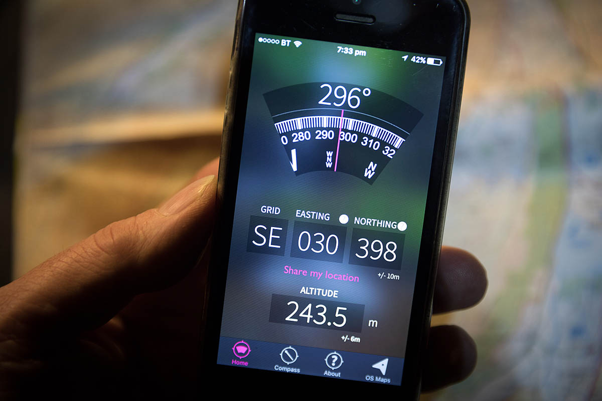
your phone can equally report your position using a string of numbers based on a pre-existing international standard
Yeah just like IP addresses for negotiating the web. Oh, hang on.... we use meaningful words don't we. I'm a mega map and navigation geek but the difference is I appreciate that not everyone is, and smartphones and GPS for everyone has fundamentally changed the way navigation can be done.
But it does work and it means that in many cases those of us in MR can get back to our beds quicker, that can only be a good thing.
The one time (in over fifty years of getting out on the hill) that I had to call MRT, it was for a walker who'd sprained her ankle, they used SARLOC. they send you a text, you click on the link in it and it opens up your map application, pinpoints your location and sends it back to them automatically. No app to install, no potential mispronunciation of words.
Something I remember from school is that the national grid ref was originally intended as a post code but I've never seen anything to corroborate this.
The one time (in over fifty years of getting out on the hill) that I had to call MRT
You do know you can use W3W for finding people and things outside of emergencies, right? That just involve a bit of fun, and that's dead simple for everyone to understand?
You keep saying that. There are reasons not to want to support wide adoption, as others have pointed out a long time ago in this thread. Do what you want for fun, it doesn’t negate their points, or mean that they should welcome wider adoption.
Well fair enough, use it or don’t – it’s your choice.
It's not your choice. Emergency services refused to attend a 10 fig grid ref unless someone walked off the hill to get a mobile signal to download W3W...
The bloke with the fractured spine was lying in running water for the 6 hours it took them to get to 5 miles from the hospital and 20m from a major A road.
Have I missed something? Did that actually happen Steve? That’s insane.
Edit: Thinking again, I genuinely can’t believe it. Some links would be welcome.
That sounds weird. last I head the scottish mountain rescue guys preferred a grid reference.
Am I being thick or does SARLOC / PhoneFind depend on a data connection? Because anyone who spends time in the hills knows that data connections can be a lot harder to get than the capability to make an emergency voice call or text that'll use any bearer and 1 bar of signal - either of which can be used (with risk/limitation) to convey a GR, Lat/Long or (three) words that the relevant apps (OS Locate, W3W, Viewranger, Google Maps) will provide irrespective of a data connection.
Am I being thick or does SARLOC / PhoneFind depend on a data connection?
It needs to be a smartphone, with a connection to the internet and the location services switched on.
Does What3words need all those things as well?
Nope, it works without data or a phone signal. It'll still show you your three word location when you open the app, probably won't load the map though. Might not work under cover.
How do you communicate your location to the emergency services? (Although you’ve been pretty clear you’re using it for other things). How do you know it’s got your location correct?
Have I missed something? Did that actually happen Steve? That’s insane.
Edit: Thinking again, I genuinely can’t believe it. Some links would be welcome.
I don't blame you... we were gobsmacked!
I'm not saying where as at the time there was a bit of fuss and those of us attending didn't mention the location as it's a bit irrelevant except the car park is 20m from a very major A road.
There were several ex forces paramedics (one of whom is married to an ex-A&E doctor from the same local hospital*) and a fully trained MTB coach and guide. He was the one who had to leave the location to download the app. I was the least qualified person there and spent my time ferrying warm clothing and such to and from the cars.
*ironically she retrained as a GP after breaking her back.
That sounds weird. last I head the scottish mountain rescue guys preferred a grid reference.
I'm sure any mountain/lowland or cave rescue would. This wasn't in any mountains (barely a hill) so it was the ambulance service (who I'm also sure can read a map).
What I got TOLD by the guy is he was TOLD on the emergency call that the emergency operator can't use a grid reference. I know him quite well so I tend to believe he didn't go and download the app just for kicks!
That’s nuts.
Who do you communicate your location to the emergency services?
Do you mean "How?" presumably without a phone sig you can't. Although you can connect to 999 on another carriers' sig. But, yeah all phones are a potential point of failure, and true of all these systems, if you've fallen and landed on your phone, and it's bust then SARLOC/location services. W3W all won't work...If you're on your own, it's back to whistle blowing, or in a group it's send one to find a phone/get a sig...just like the olden days...
@stevextc that sounds crazy, was the bloke with the broken back OK eventually? what a nightmare
that sounds crazy, was the bloke with the broken back OK eventually? what a nightmare
TBH never found out.
3 of us had kids with us and by the time the ambulance arrived we were ready to just hand over.
I have no tolerance for an organisation that promotes a protectionist proprietary system under a banner of purported benevolence.
dude, you're on the internet...
No-one is forcing anyone to use any system..jeez, talk about manufactured outrage.
Am I being thick or does SARLOC / PhoneFind depend on a data connection?
It needs to be a smartphone, with a connection to the internet and the location services switched on.
Not correct. Needs to be a smart phone, location services turned on and able to send a text message. Phonefind does not need a data connection as location information is sent via text message
If you’re on your own, it’s back to whistle blowing, or in a group it’s send one to find a phone/get a sig…just like the olden days…
Whistles are good but you should always have a mirror as well.
Whistles are good but you should always have a mirror as well.
Don't forget about flares as well
Don’t forget about flares as well
Don't they get caught in the chain?
hat I got TOLD by the guy is he was TOLD on the emergency call that the emergency operator can’t use a grid reference. I know him quite well so I tend to believe he didn’t go and download the app just for kicks!
Was told the same by a friend involved in a serious accident in the Forest of Dean recently. Boiled my piss that W3W clever sales pitch had convinced the emergency services to bin grid references.
talk about manufactured outrage
I see no such thing. I see a genuine concern that a private propriety initiative might successfully replace the existing locating system we already have. Many a business has made its offering “essential” through ubiquity, and only then sought to use that position for control and profit, which before they took over, no one had. There is also the concern that a system that requires digital location systems (gps/cell triangulation or whatever) becomes the only option, without a “conventional” paper map fallback. Are these valid concerns? I don’t know. Can you use What3Words without using a single company’s API/apps? Can alternative providers supply companies, institutions and individuals the dataset and/or translate to other location systems for you? Or are you locked into the one company? Can that one company decide to block any other company, institution or individual from using the location system? What if it becomes a safety essential, but then they block a company making nav devices, or even printing maps, from using the system? Can they do that? If so, they can get in the sea.
I had a slightly frustrating experience last year. Wasn't a 999 call, but 101 because I had a puncture on a dual carriageway and was asked by the RAC operator to ask for police on scene to cone off to make safe for their guy to do his thing. I got the OS grid ref ready, and the what3words location because I'd heard that they take those. The operator said they couldn't use either, and we had a surreal conversation where they kept saying stuff like "can you see any landmarks, a pub maybe?" and I was saying things like "on the map, find the town Wheatley, and see the A40 near it. There's a bridge over the A40 - that's xxxx Road, I'm on the A40 about 100 M East of that bridge." "Are you near a Mcdonalds?". I assume it's different on the emergency line, but I was a bit surprised that they had no better way of receiving my location. Never mind though, all worked out in the end.
(I would have changed the wheel myself, but the verge was only wide enough for the car itself, and sloping, so definitely not a good idea to be jacking the car up there with no hard shoulder for a buffer! Police and RAC guy all ace, very efficient and nice.)
I don’t think we have binned grid references yet. We get locations via GR, W3W, SARLOC, phone azimuths (sometimes, where appropriate) and good old fashioned names of ridges/gullies/routes. Then work with what we’ve got to figure out where people are.
@gray - conversely the issue you had is a total ball ache for us too. Control rooms always seem to want a postcode or building for their mapping software. Who ever knows the postcode when they’re not at home!!!
Most mapping software will accept a grid reference… that sounds like a human systems problem that could be easily solved internally. Adding What3Words to mapping software requires … what exactly? Who has the control there?
I know 🤷🏻♂️
Ten years ago when control rooms were all local you could tell them it was ‘just past xxx’s house’ and everyone would know where you meant.
By the way, I love the What3Words concept… the combination of memorability and accuracy is totalling missing from other ways of sharing a location… most have one or the other… if it was gifted to the world the way the WWW was, I’d be rubbishing the cautiousness of some towards it. Some of the posts here have made me concerned though.
If only hands.face.space was in Wuhan, China.
No-one is forcing anyone to use any system..
But this is actually the problem..
We're left funding an expensive social engineering product as part of emergency service provision because authorities didn't adopt an open standard and allowed themselves to be manipulated into supporting a proprietary system.
Both Android and iOS automatically send location when making emergency calls, so I'm failing to see the value add of W3W here.
It should not have been left to their initiative anyway. Mobile phone services are licenced, could've put a emergency location service transmitted natively with emergency calls in the service requirements years ago.
Control rooms always seem to want a postcode or building for their mapping software. Who ever knows the postcode when they’re not at home!!!
A few weeks ago, a friend out on a road ride crashed on a descent. She was with others, they phoned the ambulance and they simply would not accept W3W. The operator actually seemed very confused by these three random words being given to her and asked for a postcode - this on a country lane in the middle of nowhere.
Fortunately some local walking their dog came along and gave the postcode of his house and then a United Utilities driver passing the scene stopped to help and his sat nav had a nearby postcode so they gave that too.
Those issue was more that these adverts have convinced people that three words are all you need and you'll have a helicopter overhead in minutes. In practice, the emergency services don't all use it, their in-house software can't convert W3W to a grid ref or postcode and the satnav in the ambulance can only accept a postcode. Maybe they're just more used to operating in towns and villages where postcodes are ubiquitous and easy...?
It's primary use is as a rent extraction device for its owners, if they can gain sufficient market share.
It is utterly useless without their app, uses a non-universal language (English vs maths) and provides zero information about geography. The 3-word identification strings provide not the slightest clue whether two identified points are corners of the same building or literally on opposite sides of the planet (vs LatLong making it obvious that e.g., 52.36N 001.31W is relatively near 51.92N 001.48W), or OS Grid.
It gives zero value to anyone trying to actually navigate, without using their app, and if you are going to navigate with an app, why not use any implementation of OpenStreetMap, or even the nearly ubiquitous Google or Apple maps?
Some temporary convenience for innumerate people is not a good reason to implement a rent-extractive proprietary system.
could’ve put a emergency location service transmitted natively [sic] with emergency calls in the service requirements years ago.
100% agree, but that's not W3W's fault. You can't criticise them for having something that exists to favour something that doesn't. There isn't a standard, and the emergency services clearly aren't working to the same systems anyway. I think the message for me from this discussion is make sure I don't have to rely on any single one of these solutions.
The 3-word identification strings provide not the slightest clue whether two identified points are corners of the same building or literally on opposite sides of the planet
That's deliberate, it's not designed for navigation, it's designed to point to a place. so in that respect it's more like a post-code than a lat/long. If caller says he's in the Black mountains and gives a W3W code and the call handler mishears a word and the system places him in say: Leicester square, then the call-handler knows to check to make sure.
It gives zero value to anyone trying to actually navigate,
It's not a navigation system. There are loads of issues with W3W, and it's shady business model, and I not a "champion" of it other than it's a tool with some utility Use it or don't.
If you do need a postcode a friend of mine wrote this web app: https://www.whatsmypostcode.com/#main
Should give the postcode of your current location (if you have location turned on, and data)
Some temporary convenience for innumerate people is not a good reason to implement a rent-extractive proprietary system.
I'm pretty sure even those evil people at W3W locked in their underground bunker protected by piranha infested pools currently plotting taking over the world are not suggesting for a moment that this one app is intended or designed to replace every single navigational tool or method since the dawn of time, from the sextant to the OS map. Its just a different kind of tool that is potentially more user friendly - and if its more user-friendly it tends to be used more and more accurate.
Consider this scenario...I'm out on a lone bike ride and in the middle of nowhere in the Peak District I have a bike issue I cannot fix by the road side. I call up my wife to pick me up. I have no idea how to tell her were I am or how to get there...I could give her a long and convoluted list of directions and instructions which would stress her out ("he said 3rd left but did he mean this 3rd left which is a dirt track or the 3rd left that is a proper road....")...or I could give her my coordinates then she'd struggle to understand how to plug those into whatever nav tool she uses and could incorrectly type in a wrong number somewhere, or I can just text her or tell her 3 words and she uses the app and gets right to me. Doesn't stress her out and I know that even she can't cock it up and I will get home in time for dinner. Perfect.
I seriously doubt that the emergency services would leave people to die if they didn't embark on a perilous and long journey leaving a wounded person unattended to go and find a signal to down load an app. They might ask you to download the app that and in the meantime despatch a helicopter to go look for you and once you down load the app and tell them the location then great...another bit of information to help locate the injured person. And if all you have is coordinates then give them those and make up some excuse why you can't trek off to download the app...though I'd love to know the stats of how many times people have given duff coordinates to the emergency services and they've lost time looking in the wrong place. With the number of inexperienced weekend warriors heading out into the hills at the weekends its easy for mistakes to be made or coordinates to be misheard over a crap mobile phone line when it's blowing a gale.
It gives zero value to anyone trying to actually navigate, without using their app,
And you can't navigate with coordinates without pandering to those evil industrialists who manufacture maps and compasses and have the audacity to charge you for them. At least the app is free.
Come on...its pretty simple really and its limitations are pretty obvious. just a useful app that is cool to use if you're a yoof trying to meet up with mates in the park in a strange city or if you're a stranded cyclist trying to get your tech illiterate wife to come and pick you up in the middle of the Peak District. I see no evil here. If the emergency services want to adopt it as their preferred location tool then it must have significant merits over other methods. Just download it on your phone as one of the check items before a bit walk in the hills - map, compass, flare, mirror, whistle, emergency blanket, let someone know where you're going and when you'll be back (actually THE most important thing you can do), W3W downloaded on your phone...right, where good to go.
kelvin
Most mapping software will accept a grid reference… that sounds like a human systems problem that could be easily solved internally. Adding What3Words to mapping software requires … what exactly? Who has the control there?
That's the exact problem.
By the way, I love the What3Words concept… the combination of memorability and accuracy is totalling missing from other ways of sharing a location… most have one or the other… if it was gifted to the world the way the WWW was, I’d be rubbishing the cautiousness of some towards it. Some of the posts here have made me concerned though.
The concept of a few words is fine but implementing it is trivial. Any number of reversible algorithms can convert some numbers to some words.
The whole complexity is in making it non-reversible and 100% controlled. The licensing prevents reverse lookups anyway and can prevent emergency services using other systems.
That’s deliberate, it’s not designed for navigation
Yeah, bit of an oversight perhaps.
Our stressed volunteer services main underlying reason for being called out is because people are lost.
They may be hurt as well, they may be trapped due to not being able to read a map or tide tables or be developing hypothermia but ultimately whoever goes to help them has to get there.
Sadly the marketing of W3W gives an impression that not knowing where you are or how to get to safety is fine... don't worry a helicopter will appear magically type thing.
Sadly the marketing of W3W gives an impression that not knowing where you are or how to get to safety is fine… don’t worry a helicopter will appear magically type thing.
Sure, but folk have been calling emergency services since forever while trapped in a snow storm on Snowdon in flip-flops...Lots of folk already think that the helicopter will magically appear in the sky, this is nothing new. If they have a location app, at least the magic helicopter has a better chance of finding them.
It's a tool, nothing more nothing less, people condemning it for not being perfect or for the fact that W3W want to make money from it don't have to use it.
the deliberate not for navigation aspect can be seen in the same light as an md5sum for instance, where the smallest difference gives a completely different end result. a single byte difference in 800gb video file will completely change it's md5sum so you know it is altered. mishear a w3w word gives a completely wrong location so you know it is wrong.
It gives zero value to anyone trying to actually navigate, without using their app,
To be fair to W3W, if you tell it a valid 3-word location and ask to navigate to it, it will do so. Much the same as if you put a valid postcode or grid ref into Google Maps, OS Maps etc, it will also navigate you to it, requiring use of that particular app throughout.
The actual processes going on behind the scenes (settings like walking, cycling, driving, public transport), things like bearings/compass headings etc are never given to you, the app just gets on with it.
Apologies if its already been mentioned but isn't that a massive disadvantage?
Get a grid ref a bit wrong and you'll at least be looking on the right mountain. Mishear a single word in W3W and you'll be the wrong side of the world with no clue where to look?
Offer a free service.
Get everyone to use it to the exclusion of the competition.
Start charging.
It's hardly rocket science. We've just been through it with Strava.
It’s a tool, nothing more nothing less, people condemning it for not being perfect or for the fact that W3W want to make money from it don’t have to use it.
Agree but I don't want a penny of my tax going to fund this garbage. I want to fund something better. I've got plenty of shit mapping ideas the emergency services are welcome to spunk millions on. Sadly I've not got the marketeers or VC backing.
Get a grid ref a bit wrong and you’ll at least be looking on the right mountain. Mishear a single word in W3W and you’ll be the wrong side of the world with no clue where to look?
No, you are assuming you get the last digit of the grid ref wrong. What if I get the first digit wrong? on the leading letters, or mix up Northing and Easting. Or use GPS and miss the - sign for somewhere which could credibly be either side of Grenwich. Or read 5deg35min as 5.35 deg etc etc...
With W3W if I've called the rescue services in Scotland and the words suggest I am in Chile, or I call mountain rescue and the words place me in the indian ocean then you have enough of a "hang on a minute" moment.
Which of these is easy to mix up either hearing a bad line or by mistyping:
NM895188; NN895188; NN891588
cowering.tips.perusing; nurtures.terminal.invent; alien.soothing.clipboard
or these because the formatting on the system displaying to the two users is not identical
56°18′53″N , 005°24′18″W; 56.1853,-5.2418; 56°18.53N, 5°24.18W
cowering.tips.perusing; dispenser.dockers.marriage; rejoiced.echo.sentences
I don't think its the best thing since sliced bread, nor is it a problem that could only be solved like this... but I think if you assume the person receiving your call is competent at handling navigation data you are probably mistaken. e.g. if you give a 10 fig OS Grid Ref to someone who's system is expecting a six fig GR do they know NOT to take just the first six digits?
Agree but I don’t want a penny of my tax going to fund this garbage
Given the amount of emergency services listed on the W3W website. I think that ship has sailed.
Offer a free service.
Get everyone to use it to the exclusion of the competition.
Start charging.
It’s hardly rocket science. We’ve just been through it with Strava.
Indeed, although I heard somewhere when they first started their PR push that the revenue stream was not expected to be the emergency services, they are just the vehicle to getting the PR and maximising install base. The $$$ were to come from trying to get mail/deliveries switching to using this stuff. I can see some merit in that, 1/2 the navigation systems in the world take my postcode, street, house number to about 100yds from my actual house (as crow flies) but 500 yds driving (and I live in a town). How much time must FedEx, DHL etc waste finding the right house, and the right entrance to commercial premises etc.
exactly. It's their entire business model. Keep it free for occasional users & emergency services/charities but charge anyone putting hundreds/thousands of API calls through the system per day (on their website they mention Mercedes but obviously parcel companies could really benefit too as mentioned above)Indeed, although I heard somewhere when they first started their PR push that the revenue stream was not expected to be the emergency services, they are just the vehicle to getting the PR and maximising install base.
To use W3W I have to use their app, its no more/less hassle to use the OS locate app instead.
Is W3W really any easier to use than this? The examples you've given show words with a huge potential for spelling errors.
Is W3W really any easier to use than this?
Not for some-one who's used to being in remote places it isn't, but for the occasional aforementioned Snowdon Flip-flopper, they probs won't download OS locate, but they might have W3W already, and any dumb fool can recite three words, but they might not know what a grid ref is,
If the Snowdon Flip flop wearer and the MRT team have the same info, then the rescue will be safer for everyone. If you want to give them a Grid Ref, I'm sure they'd find you just as easily. Who cares?
@johnnystorm - you're far too close to Keighley.... run whilst you can!
Although I have OS Locate on my phone, I find the elevation to nearly always be wrong. The easting/northings are usually pretty much spot on though
exactly. It’s their entire business model. Keep it free for occasional users & emergency services/charities but charge anyone putting hundreds/thousands of API calls through the system per day (on their website they mention Mercedes but obviously parcel companies could really benefit too as mentioned above)
That's hardly exactly....
Free as in no cost or free as in free to use without draconian licensing?
Where does it say "keep it free?"
There is a guy in the park with the same business model... he starts off giving his crack away and only start charging once his customers can't live without it.
It's fine though they can just go to another dealer giving it out for free.. if they don't mind having the shit kicked out of them of course.
and of course even if the app remains free to consumers they/will will still be paying on our P&P + W3W charge.
free as in no cost, obviously. I think it's a great business model, one that is being used increasingly these days. You have to reward the time/innovation otherwise what motivation do companies have to develop new products? Yes we're relying on them to keep it "free" for Joe Public, but it makes more financial sense to keep the "free tier" as it increases the user base. I would confidently bet that they WILL keep it "free" for personal/emergency use, forever; just doesn't make sense otherwise.That’s hardly exactly….
Free as in no cost or free as in free to use without draconian licensing?
Where does it say “keep it free?”
Exactly the same strategy employed by Autodesk with their new (ish) 3D design software, Fusion 360. Totally free, built up a huge user base over the last 7 years of both hobbyists & professionals - absolutely amazing amount of features in the product. There has been a creeping monetisation over the last few years, and again this week. SO MUCH bitching & whining on the forums despite the fact it is still TOTALLY free for the majority of users, you only have to pay if you're earning significantly from it or you want to use fairly advanced design/manufacturing tools. Yes it would be a nice world if money didn't exist & everyone put effort into developing great things for nothing, sadly that is not reality!
that would reflect commercial factors so no, not necessarily. If one company absorbed the cost of W3W because it actually saved them money by allowing them to deliver more parcels in the same time then they might not raise prices regardless, as it is such as price-driven industry.and of course even if the app remains free to consumers they/will will still be paying on our P&P + W3W charge.
What three words for locating my lost Nigerian uncle?
Honestly, the naivety of some folk is astounding.
You have to reward the time/innovation otherwise what motivation do companies have to develop new products
This is essentially rewarding marketing and the drug dealer model isn't new or innovative.
Neither is giving squares names... or GPS etc.
The coding is trivial ... I'm sure they paid the lawyers far more for writing the licensing terms.
Exactly the same strategy employed by Autodesk with their new (ish) 3D design software
Nope nor is it like Komoot, Trailforks or Strava.
Rather imagine one of those wouldn't export a gpx or other navigation but not only that the license made it illegal to even TRY and export the (your) data.
Now say a courier adopts the system... but their license say's they cannot use ANY other system, no postcodes or addresses.
I don't honestly get the hostility here. I'm not sure whether it's being perpetuated aligned to open sourcers, map / outdoor snobs (me for full disclosure), freeloaders or what but if an idea sticks because it's innovative, helpful, well-marketed or 'free at the point of use' does it honestly matter? Do you think emergency services, couriers, car manufacturers or whomever that can deliver better outcomes to their 'user base' on the basis of this or other innovations, cares much that they have to pay for it? They will invariably have buying teams, and contract specialists too and will always seek to get value for money.
@Scotroutes without flicking back through the thread, not sure where the accusation of naivety is being leveled but Nigerian reference suggests you think its a racket.
To use W3W I have to use their app, its no more/less hassle to use the OS locate app instead.
Is W3W really any easier to use than this? The examples you’ve given show words with a huge potential for spelling errors.
I wrote a long answer that the forum destroyed! But in brief. You don't need to install the app - on a smartphone browser you can just use their website in your browser (but will need a live data connection). Its theoretically more precise (the base GPS accuracy is not but OS locate is only giving you ±100m), less likely to suffer transcription error, requires less talking time, and is not as intimidating to non-mappy people.
and of course even if the app remains free to consumers they/will will still be paying on our P&P + W3W charge.
You know the courier is already paying for access to the postcode database, whatever GPS routing software they use etc. They don't adopt this to put your prices up - they adopt this to save money - say 1:10 deliveries involves wasted time which W3W could save, and that averages 4 minutes of driver time and 0.1L of diesel. W3W could charge something like 5p for every package and save the company money.
Now say a courier adopts the system… but their license say’s they cannot use ANY other system, no postcodes or addresses.
Now you are imagining non-existent license terms. Especially since there is nothing to stop someone else setting up a completely analagous competitive system and licensing on different terms!
so what exactly is stopping you from developing your own totally free open-source solution thus saving the world?!The coding is trivial
Now you are imagining non-existent license terms. Especially since there is nothing to stop someone else setting up a completely analagous competitive system and licensing on different terms!
The license terms when I looked were pretty clear if well hidden...if you try and reverse engineer a location it's against the license. That includes using a paper map or other software.
Two of us both experienced this in one emergency services area.
The entire innovation here is the legal wording...
You know the courier is already paying for access to the postcode database, whatever GPS routing software they use etc
Yes an open database anyone can use and can be cross referenced with other databases.
so what exactly is stopping you from developing your own totally free open-source solution thus saving the world?!
Developing? nothing at all... but why?
Unless you have enough backing money to bribe the right people it won't be adopted any more than any of the dozens that exist already.
I don’t honestly get the hostility here. I’m not sure whether it’s being perpetuated aligned to open sourcers, map / outdoor snobs (me for full disclosure), freeloaders or what but if an idea sticks because it’s innovative, helpful, well-marketed or ‘free at the point of use’ does it honestly matter?
Yes because it is not going to stick because of any of those but because of the license terms.
Do you think emergency services, couriers, car manufacturers or whomever that can deliver better outcomes to their ‘user base’ on the basis of this or other innovations, cares much that they have to pay for it? They will invariably have buying teams, and contract specialists too and will always seek to get value for money.
So look at it like this... say Candy Crush or Minecraft or something offered this for free to the emergency services... the only condition being they can use only one and everyone who uses the emergency services or books a GP appt has to download Candy Crush/Minecraft?
At the moment I have to (optionally) have my banks app... but if I change banks I can chose a bank with a different app.
This is silly. Isn't a better analogy Paypal or the major credit card companies? Many people use it, it's (indirectly) free to us and they skim a fee from the provider of the service that depends on it, it's not the only way to pay but clever marketing, user adoption and the development of an ecosystem has made it pervasive BUT NOT exclusive?
I get the purpose of analogies but Candy Crush for a GP appointment is plain daft. If this wasn't in some way impacting the sanctity of the UK emergency services and in particular MRT/SAR would anyone actually give a shit?
The license terms when I looked were pretty clear if well hidden…if you try and reverse engineer a location it’s against the license. That includes using a paper map or other software.
Two of us both experienced this in one emergency services area.
I don't know if the two of you both misunderstood the license terms or are poorly explaining your gripe. W3W specifically provide a tool (an application programming interface) which enables you to turn any.three.words back into coordinates. They don't care what you do with those coordinates, other than use them to build a replica of the their service such that their service is no longer required. Not only is it permitted - it IS their business model. What you wrote originally implied that using any other system in parallel would be a breach of their T&Cs - which is clearly bollox.
Yes an open database anyone can use and can be cross referenced with other databases.
Unless royal mail have changed their position Postcodes are not free. However the issue is nobody has a global address system that is cross referenced. That is what I believe W3W are trying to end up with... and of course own!
This is silly. Isn’t a better analogy Paypal or the major credit card companies? Many people use it, it’s (indirectly) free to us and they skim a fee from the provider of the service that depends on it, it’s not the only way to pay but clever marketing, user adoption and the development of an ecosystem has made it pervasive BUT NOT exclusive?
I get the purpose of analogies but Candy Crush for a GP appointment is plain daft. If this wasn’t in some way impacting the sanctity of the UK emergency services and in particular MRT/SAR would anyone actually give a shit?
If Paypal were to give a free service to say NHS that is one thing.
If they then said if you ever allow any other payment method we will charge you for EVERY transaction ever made since you used our system.
but Candy Crush for a GP appointment is plain daft
Probably but why?
A company simply say's "we have developed and payed for a mobile booking system for free all you need do is sign up to an exclusive deal and force your patients to download the app".
I thought W3W was sposed to be tuned to local language too, so say you're up an Alp and call mountain rescue but have the UK app, will it dish out the English or German words, and would Austrian mountain rescue expect or understand any language's words?
In a way it's a shame the Google equivalent is not so well advertised and promoted, cos that's 6 alphanumeric characters, totally global with a single grid, no licence whatsoever (even though it is big evil business), the code is fully open source for anyone to use, and I expect practically everyone already has gmaps on their phone anyway (with no data connection necessary to spit out a grid ref, just need GPS).
And in the worst case, english numbers and the international alphabet are globally understood.
I don’t know if the two of you both misunderstood the license terms or are poorly explaining your gripe. W3W specifically provide a tool (an application programming interface) which enables you to turn any.three.words back into coordinates.
..
They don’t care what you do with those coordinates, other than use them to build a replica of the their service such that their service is no longer required. Not only is it permitted – it IS their business model. What you wrote originally implied that using any other system in parallel would be a breach of their T&Cs – which is clearly bollox.
I missed what you misunderstood...
In particular, you must not allow any user to reverse-engineer a 3 Word Address Location
from a 3 Word Address and you must not display a 3 Word Address alongside a 3 Word
Address Location.
Which part of having to use an closed API is acceptable to be forced on the end user for a life and death service?
I'm really struggling with W3W. I have yet to find a single amusing or smutty three word phrase that resolves to a real location.
Re languages, there is quite a long list on the website in which you can choose to have your words. And you can apparently type any of them in and they'll resolve to a location.
I thought W3W was sposed to be tuned to local language too, so say you’re up an Alp and call mountain rescue but have the UK app, will it dish out the English or German words, and would Austrian mountain rescue expect or understand any language’s words?
I believe that's another criticism that's been levelled - if your English location is cheese.cake.wine then the French equivalent is not fromage.gateau.vin, so if you are lost in France (with or without bonnie tyler) then having the English W3W app is no use to you - you'd need to download the french version then hope your pronunciation is clear enough for the operator.
single.track.worlds is in Hyderabad.
single.track.forum just outside Baltimore. Not sure if there's any local trails.
Best one so far - middle.class.whiner is about half way between Madrid and Barcelona and looks to have some great riding potential as it's right up in the mountains.
I've run out of argument power. I'm off to find the smutty 3 word location.

Hmm. middle.aged.cyclist is in the sticks about 60 miles north of Roswell, NM. Makes you think, doesn't it?
Also really disappointed that what.three.words does not resolve to their HQ.
A company simply say’s “we have developed and payed for a mobile booking system for free all you need do is sign up to an exclusive deal and force your patients to download the app”.
That's not W3W's business model though is it? They haven't said "you can only use W3W and no other system to pin point someone". You can't criticise them for doing stuff you've made up in your head.
maybe you need some front.bottom.tips?
That’s not W3W’s business model though is it? They haven’t said “you can only use W3W and no other system to pin point someone”. You can’t criticise them for doing stuff you’ve made up in your head.
I quoted a small part of their license.
you must not display a 3 Word Address alongside a 3 Word Address Location
If you read the whole lot substituting THEIR contractual definitions then it does.
For example:
“3 Word Address Location” means the latitude and longitude coordinates derived from a 3 Word Address (with or without the corresponding 3 Word Address).
This has obviously not been written by or for a geodetic specialist and without one telling procurement that there is no such thing as a unique latitude and longitude coordinate without defining the CRS.
Hmmm, they have a clause in their T&Cs stating that they're happy for Charities and NGOs to use the service for free. I'd imagine that's going to cover most MRT teams/coastguard...etc.
Hmmm, they have a clause in their T&Cs stating that they’re happy for Charities and NGOs to use the service for free.
No they don't, the clause SAYS
If you are an NGO or a charity, you may be entitled to use the API for free up to 75,000 convert-to-coordinates requests per Month
(bold mine)
