![]() You don't need to be an 'investor' to invest in Singletrack: 6 days left: 95% of target - Find out more
You don't need to be an 'investor' to invest in Singletrack: 6 days left: 95% of target - Find out more
I've looked for local routes on lots of different sites but not really found anything which is kinda what I expected as I know there isn't a great deal of off road riding to be done around here. I'm more than happy to make do until I have my own transport so I can travel further away.
I've started to experiment with bike hike and have made a few of my own 20-30 mile loops, mainly bridleway with single track roads linking the off road stuff, incorporating a few cheeky footpaths too that are in better condition.
It's trial and error, some of the bridleways have just been impassable due to 4x4's and horses but others have been gravel/shingle and been lovely. Others have passed farms with aggressive dogs that have chased me off so gave those a miss!
Whats the deal with unmarked roads/tracks tho? On my OS map it shows as a pair of black lines running parallel to one another, are they are public rights of way or just farm road? I can't be bothered with "Get off my land!" situations towards the end of a ride or have any of you found land owners quite reasonable towards you riding on tracks that aren't marked?
Generally, its just a farm road.
i depends to some extent on how up to date you mapping is, as there are often higher rights that are not shown on the OS map, such as ORPA.
a lot of councils have the definitive map online now, which an reveal some more tracks.
As far as I understand it then if it isn't a road, bridleway or By-Way then we have no "right" to be there on a bike. The tracks you mention tend to be old farm roads or all weather farm tracks. An example by me is an old disused air field has the runways marked as you describe. As far as I can see we have no "right" to cycle there. It would be trespass the same as anywhere else we don't have a right of way which in practical terms just means the landowner would have to ask you to leave by the shortest route...
The interesting thing I noticed on the link above is that routes marked with green diamonds are "recreational routes".
Recreational route - these routes are suitable for walkers, cyclists and horse riders. They are regional routes that will be sign posted.
There is a very nice linking route marked as such by me with stiles and footpath marking. Can we ride on it? I suspect the definition quoted above is ambiguous and what it should say is that recreational routes may be on footpath, bridleways or by-ways in which case it is possible for walkers, cyclists and horse riders to have access..
On my OS map it shows as a pair of black lines running parallel to one another, are they are public rights of way or just farm road?
pylon lines
To be clear, the farm tracks/ old roads with no right of way are parallel dotted black lines- I had assumed this was what the OP was referring to. Otherwise SA is likely to be correct
Danw - yes, its not very clear - it would basically indicate the existence of a 'waymarked' route like the ridgeway - but part of the ridgeway is footpath only, while other stretches have higher rights
The key lists them as 'other road, drive or track'. My experience is that that they tend to roads/farm tracks on private land. Mostly no access although you do find the odd one that can be used, but unless you had local knowledge I would assume no access..
pylon lines
Electricity pylons lines are a single black dashed line with squares interspersed along the line to show the position of the pylons. The squares are replaced with circles if it'a a low level power line supported by poles.
Thank you all for your input, I think you are correct DanW.
I've found the village website and it's clear it's not a right of way, sorry to use such a particular example but I've leant lots just from the few comments for future reference.
Anyway, here is a local map, the track in question runs from (R)ectory Farm to Coolington Farm.
[img] 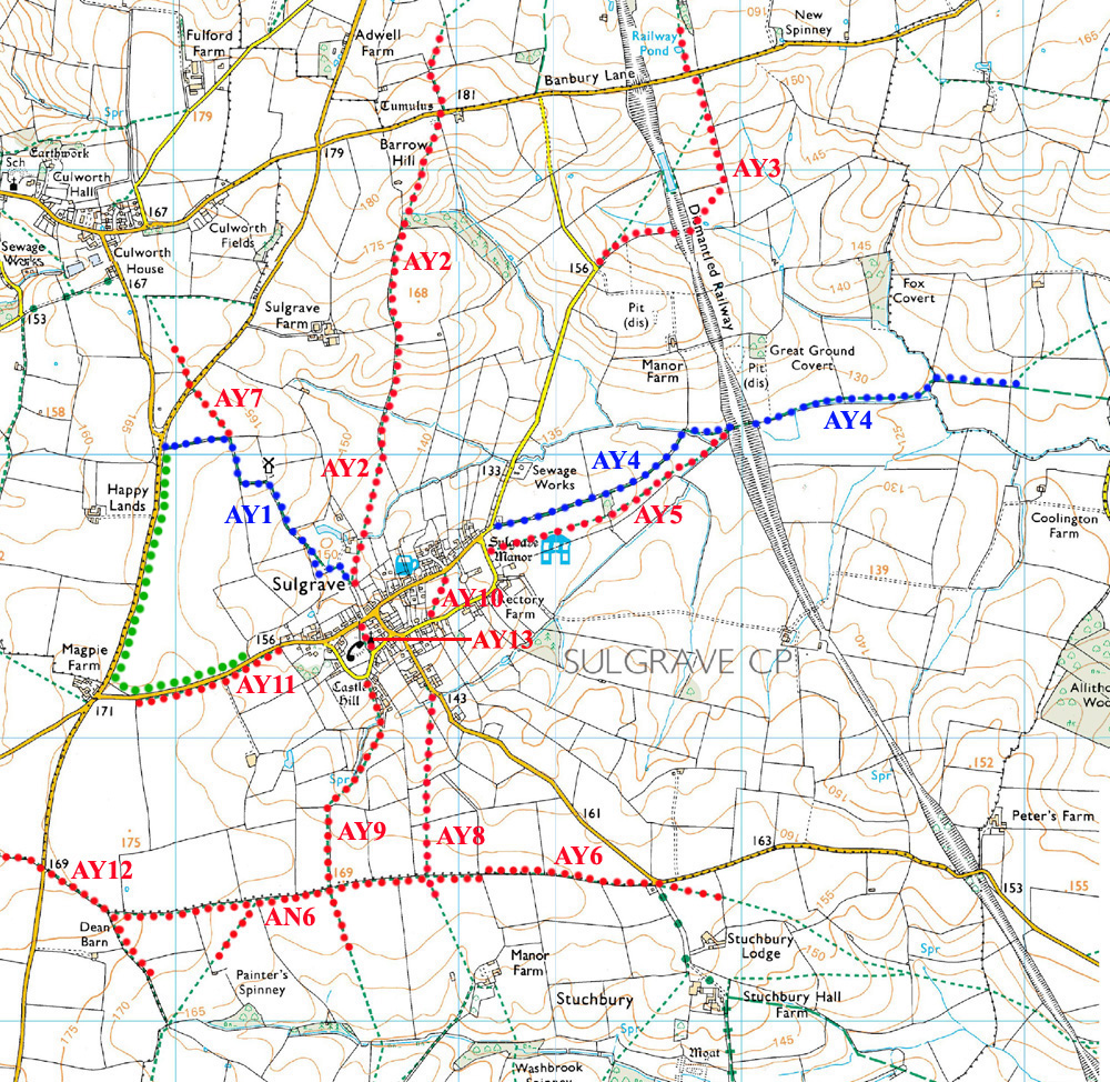 [/img]
No you can't just cycle on them, unless you live in Scotland 🙂
I spend hours plotting routes using:
http://wtp2.appspot.com/wheresthepath.htm
And then go and ride them, its brill. 🙂
[i]the track in question runs from (R)ectory Farm to Coolington Farm.
[/i]
That's just a farm track. I believe that a dotted line means it's unfenced, a solid line means it's fenced.
Are all of the green dashes not rideable?
What are all the red and blue dots? looks to be edited just on that Village website... Conspiracy theory?
Look at Bing Maps (really handy), change the tab from roads to OS and all of the routes off that village look to green and marked as bridleway, hence ok?
Though I live in Scotland and may be totally wrong...
short green dashes are footpaths, long green dashes are bridleways
see the difference at the right end of the blue AY4 dots
and some other interesting examples at Stuchbury hall farm - BOAT and ORPA - both of which you have a right to ride
You can always go and ask the farmer/owner for permission?
If it isn't marked as a public right of way, then no, you don't have a legally enforceable right to use them.
On an OS map, roads which are coloured show that they are surfaced - blue for motorway, red for A-road, orange/brown for B-road, yellow for unclassifed/C-road.
No colouring simply indicates that the road is unsurfaced.
A good example is Mastiles Lane in North Yorkshire. The section between Kilnsey and Mastiles Gate is only marked on OS maps as a traffic-free route (i.e. no motor traffic - widely-spaced red dots). Between these points it is not technically speaking a public right of way, but it is an unsurfaced road. Only from Mastiles Gate to Street Gate is it a public bridleway, and therefore a PRoW.
Sulgrave!
By a road bike, until you can drive 🙂
Ahaa, I was confusing dots with dashes...
Thanks again guys, I think I'll give that particular track a miss and try find some alternatives.
Some interesting reading in this post
currently and there are people on here more expert who can give the date when the law changes in England (sadly) but at present just because a feature isn't marked as a right of way doesn't mean it isn't. (full stop) might not mean you can ride it without grief but simply that it has not been correctly recorded - claiming rights of way is hard but not impossible - look at at local council website
one problem with OS mapping/LA responsibility is "unclassified lanes" these are a right of way but on ground look like private access roads and as are not Bridleways/Footpaths/Byways don't have to have signs
sadly most local authorities haven't the time to look at these pro-actively and up date so are being lost