
Watched a YouTube film about a group of mates doing bikepacking on Klunkers last night. Because of the lack of gears the route was heavily based around long distance railway trails. Actually looked like fun due to the low elevation riding meaning it wasn't a horrible climb fest slog, something I'd do on my SS CX probably.
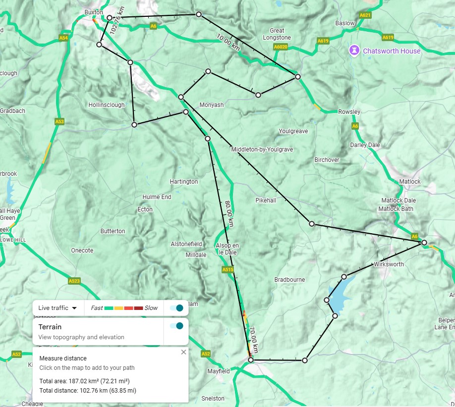
So, does this Derbyshire peak district route look practical? Would be nice to be 103 miles instead of 103 km, but I can't see a way of extending the route in a fairly flat manner and keep it circular.
Buxton - Bakewell, Monsal trail.
Bakewell - Hurdlow, road.
Hurdlow - Lea Bridge, High Peak trail.
Lea Bridge - Asbourne - road and Carsington Water trail.
Ashbourne - Parsley Hay - Tissington Trail
Parsley Hay - Buxton, road.
Actually looked like fun due to the low elevation riding meaning it wasn't a horrible climb fest slog, something I'd do on my SS CX probably.
Well - it won't be flat that's for sure!
The trails bits in the main will be (apart from the bit from Cromford Canal to Middleton Top which is a barsteward!). But the road bits in between will have some steep bits and many draggy climbs.
Lea Bridge - Asbourne - road and Carsington Water trail.
That's pretty much all up-hill and the main road is not a fun road to ride.
Maybe something following canals would be more suitable?
Great video btw
Getting out of Buxton to the start of the Monsal Trail is a bugger, it's several miles along the A6 which is a busy road with not much space. You could head out along Waterswallows road then either follow it down through Wormhill to join the Monsal Trail at Millers Dale, or turn right to Tunstead and descend the zig zags to the very start of the Monsal Trail
You'd probably be better getting the train to Whatstandwell or Cromford. Canal to High Peak junction - bugger of a climb to Middleton top, then HPT is pretty flat all the way to the end. Drop down over to Millers Dale and down the Monsal Trail to Bakewell. From here you can either follow Coombs Road to Rowsley and then the cycle path to Matlock. A bit of road which isn't bad back to Cromford - climb again to head to the HPT to the Tissington trail.
Or, rather than go all the way to Cromford, you could head over Youlgreave or Winster up to Mouldridge Grange - can mostly be quiet(ish) roads. Then on to HPT at Mouldridge to pick up the Tissington to Ashbourne. From Ashbourne there's a nice back lane route to Carsington, then back onto HPT to descend to Cromford.
Not sure on mileage, I've only done it as two separate rides from my door. One of them on its own was over 50 miles though
Am interested in a similar route, so put this in RidewithGPS and its definitely not flat - 1550m of climbing!
https://ridewithgps.com/routes/53378241?privacy_code=FTKMbv3mq0xuqHkpj9kfWZdP8LIvxSCd
This was the Tissington loop from Darley Dale
Check out this Flyover of my activity on Strava: https://strava.app.link/B9SOoJXQyYb
And this is the HPT, Monsal loop
Check out this Flyover of my activity on Strava: https://strava.app.link/AfYE8Q8QyYb
Not sure why it's only letting me share flyovers
+1 for everything @nbt says above - Buxton to Miller's Dale start of the Monsal Trail is horrendous along the A6, you're far better off going ENE out of Buxton and via Fairfield > Waterswallows > Hargatewall > Wormhill then dropping down to Miller's Dale. But it's hilly, the climb out of Waterswallows is a pig.
The trails are (obviously) all flattish, Monsal is ever so slightly downhill in the direction of Bakewell.
Bakewell to Hurdlow is all uphill although you can go via a couple of gravel tracks and some quiet lanes via Monyash.
Parsley Hay to Buxton, use the High Peak Trail up to Sterndale, then the quarry gets in the way and you either have to thread across a couple of busy roads to go via Chelmorton and Harpur Hill or take the lanes through Earl Sterndale and up (much up!) past Buxton Raceway.
I remember coming back from a big day out via Earl Sterndale, that climb up from there all the way past the Raceway and on up to Axe Edge left me in pieces. I was a broken man by the time I reached the summit, about 4hrs* after I'd started.
*It wasn't 4hrs, it just felt like it.
I reckon the route would be better the other way around, try re-plotting it anti-clockwise.
I reckon the route would be better the other way around, try re-plotting it anti-clockwise.
We recently did something like this on the tandem - the biggest issue would be getting from the end of the Monsal Trail over to Buxton. Would concur though that direction is likely better
We recently did something like this on the tandem - the biggest issue would be getting from the end of the Monsal Trail over to Buxton.
Agreed - you can carry on from Miller's Dale to Blackwell Mill then at least the A6 is mostly slightly downhill from there into Buxton but it's still a horrific bit of road, I wouldn't go near it.
Other option of course is Miller's Dale then the reverse of the route I described earlier - up to Wormhill then Hargatewall, Waterswallows and Fairfield. Still a climb out of Waterswallows (although less bad than the other way!).
That Buxton to Monsal missing link comes up regularly in active travel conversations.
You'd probably be better getting the train to Whatstandwell or Cromford. Canal to High Peak junction - bugger of a climb to Middleton top, then HPT is pretty flat all the way to the end. Drop down over to Millers Dale and down the Monsal Trail to Bakewell. From here you can either follow Coombs Road to Rowsley and then the cycle path to Matlock. A bit of road which isn't bad back to Cromford - climb again to head to the HPT to the Tissington trail.
Or, rather than go all the way to Cromford, you could head over Youlgreave or Winster up to Mouldridge Grange - can mostly be quiet(ish) roads. Then on to HPT at Mouldridge to pick up the Tissington to Ashbourne. From Ashbourne there's a nice back lane route to Carsington, then back onto HPT to descend to Cromford.
Not sure on mileage, I've only done it as two separate rides from my door. One of them on its own was over 50 miles though
You could wring a couple more miles if you started at Ambergate - its only a couple of hundred yards on the A6 (or pavement !) to get onto the canal (up the quiet Chase Road off the A6 to get much closer to the canal's start/end).
I realise this is a potentially only partially helpful comment, but…..
I did one of the Glorious Gravel rides out of Buxton a few years ago and it threaded up out of Buxton, fairly immediately going off-road and out to Millers Dale, so no need to touch the A6 - but it was pretty steeply up on the way out of town and out onto the open moors - but no harm in walking some of it if you needed to (you’re breaking it up over a number of days anyway I guess, so no need to rush!)
Having only discovered that area in the last 10 yrs or so, what I would say about that part of the world, and particularly all the old rail trails, is that it’s a bit of cycling heaven! Enjoy 👍
Yeah, I'm not a million miles from the area and have ridden most of the tracks at different times, bit I've not got the detail in my head how they might all link up sensibly together.
Adding the canal in seems like it would be worth investigating.
Adding the canal in seems like it would be worth investigating.
It's only short, but very pleasant in summer/autumn. Runs from Ambergate to Cromford
I did one of the Glorious Gravel rides out of Buxton a few years ago and it threaded up out of Buxton, fairly immediately going off-road and out to Millers Dale, so no need to touch the A6 - but it was pretty steeply up on the way out of town and out onto the open moors
Trying to think which way you'll have gone...?
Did it go out to Harpur Hill then up a gravel track behind a pub called Parks Inn? Or was it out via the golf course at Fairfield and then right onto a singletrack lane turning to a gravel track?
The cycle.travel app gives this route when you ask for gravel from Buxton to Millers Dale

The loop we did that I referred to earlier is the White Peak Loop
https://www.derbyshire.gov.uk/leisure/countryside/access/white-peak-loop/white-peak-loop.aspx
We started at Topley Pike, went south on the Tissington Trail then back northwards on the Monsal Trail
As I said on Strava:
We rode it so you don’t have to. Top and bottom ends are horrible: top end is a horrific push up the limestone of the Pennine Bridleway, the southern end is a horrible mess along the main A6 road dipping along various bits of “repurposed” footpaths. Rest was nice though
https://www.strava.com/activities/15787215345
I did one of the Glorious Gravel rides out of Buxton a few years ago and it threaded up out of Buxton, fairly immediately going off-road and out to Millers Dale, so no need to touch the A6 - but it was pretty steeply up on the way out of town and out onto the open moors
Trying to think which way you'll have gone...?
Did it go out to Harpur Hill then up a gravel track behind a pub called Parks Inn? Or was it out via the golf course at Fairfield and then right onto a singletrack lane turning to a gravel track?
You’re right, it was Harpur Hill - little narrow path behind a pub out onto a wider gravel track….and I remeber a sharp right through a gate once we were out on the open hillside…..it was a good route