![]() You don't need to be an 'investor' to invest in Singletrack: 6 days left: 95% of target - Find out more
You don't need to be an 'investor' to invest in Singletrack: 6 days left: 95% of target - Find out more
Hi all
My Locus Pro (now Classic) android app no longer appears to have any purchased offline maps, I can't seem to re-download them from my purchase history and trying to contact their customer support via the app has so far proven impossible.. Some of this may be down to the account being registered to a now defunct email account I can no longer access, irrespective I've somewhat lost confidence in the product despite it serving me well in the past..
I'm after proper hiking and biking maps for the UK and Europe, something like Locus but not Locus...
Prefer a one off payment to a subscription.
What do folk use?
TIA
Prefer a one off payment to a subscription
I think these days you'll find that covers paper. Plenty of stuff grandfathers permanent mapping but I'm not sure you can actually buy it for anything these days.
You can get full os mapping for garmin devices - and I assume competitor products - but it needs a garmin device to run on so far as I know.
Maybe try something like talky toaster (lots of folks say his maps are better than os, can't say I got on with them). There may be an app that can run his mapping.
FWIW I use (£27pa) outdoor active and get on with it well enough, the offline mapping isn't brilliant/intuitive though.
OS maps app worked well for me for *some* things in the past but was terrible for other stuff.
I use memory map. You have to pay for each updated OS map as it comes out but it continues to work with the older maps
Europe I use online mapping but I think you can get the french maps offline as well
Openfietsmap.
Back Country Navigator Pro Version has OS map access which can be downloaded in selectable areas to your device. I don't use it for drawing routes, only for following routes drawn elsewhere, but it is good as a map in your pocket.
It is a one off payment and not a subscription.
In that app there are a few different layers worth trying when in Europe. I prefer 4UMap topographic, but Thunderforest outdoor and Open Cycle Map are sometimes useful.
I think I did once use Locus for a voice navigation feature, but that was some time ago now. I haven't needed that feature again, but haven't found it in another app.
I use memory map. You have to pay for each updated OS map as it comes out but it continues to work with the older maps
Picking up on TJ's post, memory map often has some good discounts on bundles of you're not in a hurry.
Same as TJ and Dangeourbrain I use MemoryMap. Have an annual subs that means i have latest maps all the time. Can download map areas to phone to use offline
Haven't found anything that works for abroad
Depending on the type of map I have found maps.me to be very good for offline use. The maps are more designed for road use but they do have an awful lot of trails and paths on. No distinction between bridleways, footpaths, forest tracks, etc but popular cycle trails, such as those at trail centres, are clearly marked. Might not be ideal as a primary map but it makes a great back-up to an OS map app especially when out of the UK. Full worldwide mapping, downloadable by area, free!
Back Country Navigator for me as well. Also use OSMAND if I want turn by turn. Mostly use standard garmin maps on my edge for ease of use when riding and BCN OS maps on my phone for more detail when stopped.
Amazed at how many paid for/Subscription based mapping systems seem to frequently dump users access and mapping purchases. BCN isn't perfect but I paid once years ago and have installed it on my past four phones.
There's always Komoot I suppose which is OK for routing but even the first tier of premium paid for maps are rubbish. I might just be based as it seems like the Uber of map apps trying to blitz the opposition under the weight of over promotion and ambassadors.
Thanks all, having a poke about the various different subscriptions I seem to have already set up. Just accessed Garmin Explore as have a Garmin account, from an initial scan, whilst using the Open Source Mapping, the free UK TopoActive map appears to lack the detail I'm after for smaller paths. Can't see how to access any other maps.
I made a one of payment for something on Komoot a couple of years ago for what I think is full access to UK and Europe, will have a rummage to see if I can access offline versions.. They appear to have changed their subscription model since.
Locus allowed large chunks (half of France, all of Scotland etc.) at reasonable detail to be downloaded and could be relied on in very remote locations, I used it for hiking in the Pyrenees and Alps including the TMB, currently I use my Garmin Edge 530 for bike rides, for hiking it lacks resolution for off the beaten track.
Only after viewing with geolocation with GPX overlays a nice to have, have various means to create routes on PC independently.
Will have a look at Memory Maps and BCN..
Edit.. I also appear to have access to offline maps via Komoot globally.
Cheers
FYI: Gaia maps have various European topo maps (inc French and Spanish IGN) plus lots of generic topo maps (eg OSM) and you can actually blend together two different layers.
No idea of cost though, as I get "free" access as part of Outside membership.
Garmin - try TalkyToaster.
Just £13 and the detail is most excellent (Open Street Map base but with added details like contours)
I made a one of payment for something on Komoot a couple of years ago for what I think is full access to UK and Europe, will have a rummage to see if I can access offline versions.. They appear to have changed their subscription model since.
Last time I looked you can buy access to particular regions across the world for a relatively cheap one-off payment (and there are regular deals as well. I got worldwide maps for $20 I think) PlUS (and entirely separately) you can pay monthly for "Premium" access which gets questionable functionality such as turn-by-turn voice navigation and weather reports
Offline map options in Google Map?
If you use a Garmin, I'd also recommend TalkyToaster. Cheap, good quality,and good tech support.
You can also load the maps into Basecamp for many hours of tea fuelled route planning at home
Cheers all, Talkytoaster does look interesting.
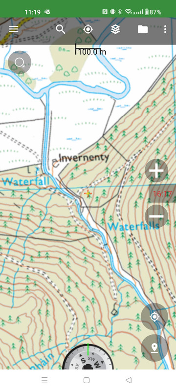
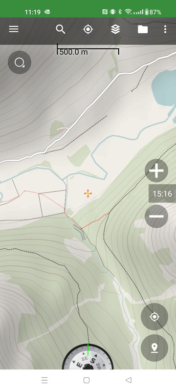
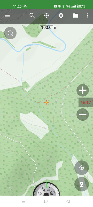
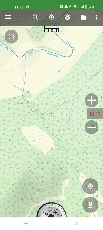
So following a bit of off piste confusion the other day thanks to Komoot routing, screengrabs from various apps I have below for comparison:
Komoot with route in blue
[img]  [/img]
Similar section from Garmin Explore - smaller paths don't appear..
[img]  [/img]
Google maps topo - zooming in closer loses the contour lines.. fairly useless in this context
[img]  [/img]
Locus LoMap - similar to Komoot, uses same OSM base
[img]  [/img]
And then the daddy, OS map from Bing (can't seem to access the OS map on my phone. This actually shows the trail carrying across the stream higher up and then the path heading NW on the west bank. I may look into updating the OSM.
[img]  [/img]
I may be missing something in switching on the detail... but clear differences..
This was in the news last year after MRT call outs in the Lakes.
AllTrails shows a path which doesn't exist. I assumed these apps all took their mapping from OpenStreetMap but obviously not.
OSM doesn't show this path. Strava shows nothing on the heatmap but does show crags on part of " the route" (attached).
I'm a long term user of Backcountry Navigator (and a fairly recent user of Gaia). Both are a bit rubbish for planning purposes (I tend to use Komoot for planning) but the big advantage of BCN and Gaia is they allow you to switch layers, which can be very useful in-the-field (assuming you have phone coverage or have download the map tiles in advance).
If the current on-the-ground conditions don't match the map, switching layers may help...
(Plus, I've got at least 7 different mapping apps installed on my phone so can switch apps if I'm really lost!)
Have you looked at Fatmap? Similar pricing and for that you get actual os/ ign etc mapping and satellite imagery and in 3d or 2d and offline downloads are available...
Just looking at Fatmap Mugsys, and it seems I have membership through my Strava premium subs. Not sure yet if that allows me to download for offline mapping
@Davy90 this is the same location on BCN.
There are clearly differences between the map information layers, but at least all this information is available in the same app.
BCN OS
BCN 4UMap
BCN Open Cycle Map
BCN Thunderforest Outdoor (online only)
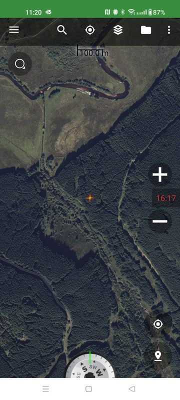
BCN Virtual Earth Satellite
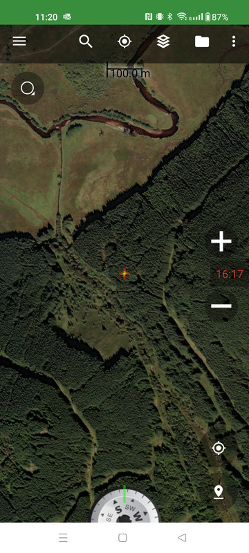
BCN ArcGIS Worldwide imagery
Just seen this, thanks for replying and will look into BCN..