![]() You don't need to be an 'investor' to invest in Singletrack: 6 days left: 95% of target - Find out more
You don't need to be an 'investor' to invest in Singletrack: 6 days left: 95% of target - Find out more
my only worry is navigation - is there much scope for getting totally lost with this route?
http://pedalnorth.com/content/nan-bield-and-garburn
Dead easy navigation wise
About the only bit that might be tricky is finding the descent from the ridge down in to Troutbeck. It's not a massive track and it's all a bit grassy round there.
also found this http://www.gpsies.com/map.do?fileId=vxhevgbbbxohftzq
I've done it opn my own a couple of times. Navigation is easy. The crashing and being on your own on the fell for 3hrs is a little more of a worry but most of the route is reasonably well visited.
Just be aware that there's some sort of Folk Festival on at Staveley this weekend so Wheelbase / Wilf's / Hawkshead Brewery will all be extremely busy and parking will be difficult there.
Got to say though that the Descent of Scots Rake is IMO a waste of good height. Also, climbing up to Nan Beild from Kentmere is the wrong way. Long way to go to be disappointed with the route.
Which track/BW/descent is Scots Rake?
That's the most backwards route ever! Why anyone would climb up Nan Bield from Kentmere is beyond me. A better route (and one I did last Saturday), would be to go up the back of Garburn past Dubs reservoir, then turn left onto the Ill Bell ridge once you hit the top of Garburn. Follow the ridge, then drop down to Nan Bield. Then you can either head left and descend to Haweswater (amazing but techy) before returning up Gatesgarth and Harter Fell, or you can drop straight down Nan Bield towards Kentmere.
[url= https://www.strava.com/activities/658617146 ]Nan Bield both ways[/url]
[url=
I did part of that route a few weeks back for the first time and found the Nan Bield descent really disappointing, I imagine peddling up it wouldn't be much fun at all, unless you have pretty good trials riding skills and want a really technical challenge.
Probably due to my lack of skills, but I found Nan Bield nothing like the flowing ribbon of lovely singletrack the magazines would have you think. I found it so rocky, muddy and rutted it was hard to get any flow. I know the whole point is it isn't a groomed trail centre, but I wonder how many people ride it expecting a nice fast flowy descent only to be stop/start for the next few miles.
There are better (more fun) routes round Kentmere imho.
the thing is I'm solo and dont really know the routes.
Get on with it. Back int day we did it with a water bottle, packet of fig biscuits and a pacamac. Bike was a Muddy Fox, we lived. There is nothing available for navigation or to ride that has made doing rides in that area any better than its always been, bit easier on the arsenal mind. It really is a great place to be on a week day, you'll have a great time. Bear in mind you may be walking down as well as up.
other routes I had in mind was
broughton moor / seathwaite (I know this area better as I road bike around here a lot)
borrowdale bash (but thought this might be busy on a sat morning)
do the gpsies route, you can't miss it's well defined paths all the way and the only way to go is the way you are going for most of it.
Lowey, do you lot from Bolton still venture out regularly?
Which track/BW/descent is Scots Rake?
[url= http://www.streetmap.co.uk/map.srf?x=343133&y=508833&z=120&sv=343133,508833&st=4&ar=y&mapp=map.srf&searchp=ids.srf&dn=651&ax=343133&ay=508833&lm=0 ]Scots rake.[/url]
Lowey, do you lot from Bolton still venture out regularly?
Sadly not Craig... Real life getting the way too much at the moment.
@lowey - thought it might have been that but the name doesn't appear on any maps, go to the 1:25000 on streetmap and it isn't shown any name either, Park Fell is assigned to the general area. There's no Strava segment of that name thereabouts.
Justin - I might try your route - anything to be aware of?
Sefton - only a couple of things to note - when traversing across to Mardale Ill Bell, it is easy to get sidetracked and start descending the ridge to your right (Lingmell End). Also, the descent down to Haweswater is very techy in places. If you're not familiar with Lakes riding or in the right mindset, it could just frustrate you. It adds about 2 hours to the route, so if you're short on time just turn right at the top of Nan Bield and descend into Kentmere. Other than that, have fun!
@whitestone...
Wainwright had it described as Scots Rake years ago... I also recall it called that on older maps I used to use. Sadly, the name does not seem to have been carrier forward by the OS.
https://en.wikipedia.org/wiki/Thornthwaite_Crag
[url= https://c7.staticflickr.com/9/8701/28163006574_18efc87056_o.jp g" target="_blank">https://c7.staticflickr.com/9/8701/28163006574_18efc87056_o.jp g"/> [/img][/url][url= https://flic.kr/p/JUELES ]scot rake[/url] by [url= https://www.flickr.com/photos/dave-lowe/ ]Dave Lowe[/url], on Flickr
I did Nan Bield including a cheeky reccy a few years ago before our group ride. No problem as there are always walkers around.
just pieced together Justins route on streetmap OS. and added a bridal way from Kentmere back down to Ing (instead of the road)
will probably miss out the decent to Haweswater I might have to factor time getting lost into the day. plus I'll be in full Lycra 🙂
On that gpsies route, the obvious cheeky shortcut over Harter Fell is worth considering.
just watched a few videos - wow, didnt realise there was so much ridge riding - gulp!
That Pedalnorth route looks like a truly awful waste of altitude.
The gpsies route is a bit short and the descent of Gatescarth to Haweswater is another waste of altitude. This is where a climb from the top of Gatescarth over Harter Fell is better, but then you'd have an even shorter route!
justinbieber's route is the pick of that bunch. It's spookily similar to the route we took exactly a week earlier. We just did a bit more off road at the start of the route.
[url= https://www.strava.com/activities/650739837 ]Nan Bield Twice[/url]
If you don't fancy the techy descent North off Nan Bield, just drop that (and the return to Nan Bield over Harter Fell) and descend from Nan Bield South back into Kentmere.
going to do this but without the loop down to Hayeswater
[IMG] 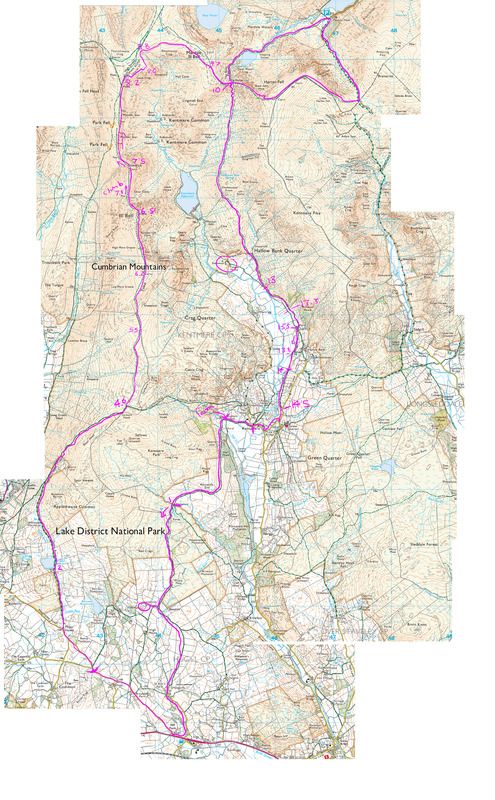 [/IMG]
cheers Ian.
Decent Route that Craig. Did something similar a few years ago with Gavgas and a few others.
Hopefully make it back alive...
100mm travel & race tyres 😯
not done these kind of rides for years.
Itll be reet, Craig.
Was up that way last w/end to catch one of our lot running the Lakeland 100. It reminded me of how nice it is up there. We're going back next week to run the Kentmere Horeshoe with the dog! Have a good 'un, mate.
cheers, Just got Caitlyn into Horwich RMI 😉
Cool! Good club, that.
I was miles away when you pipped at me at the lights t'other night!
Great route guys. quite a bit of hike a bike towards the summits of each peak but the views where well worth it.
underbiked on the f29 but was glad for the light weight on the climbs.
Agree with the comment above about Nan Bield decent - so different to the photos. much steeper, rougher and tighter (mostly a carry) 😳
the ridge singletrack around Mardale ill bell was great. also the trails down to Kentmere (after the Nan Bield decent).
Loads of bridleways from Kentmere back to Ings (loads of gates too)
around 5 hours in the saddle (with stops to take in the views and exploring around some old Settlements).
I carried so many of the steep descents. the ride really brought home how shit I am (scared on the really steep rocky stuff)
didn't see another rider all day until I got to Kentmere.
cheers
Craig
nice one, any pics??
nope, phone has no camera 😳
Nice one. Do a bit more lakes riding mate... you'll soon find your feet.
Glad to hear I'm not the only one who doesn't really enjoy things like the top of the Nan Bield descent. Was a bit much for us on the tandem! Will be heading up staveley way again in a day or two, but not doing such a big route...garburn and green quarter is more likely.
Were you by chance riding a Giant and wearing wiggle kit? If so we were sat outside the Church in Kentmere in the morning snacking part way round 4 passes
nope, CAAD F29 - Fidea telenet jersey