![]() You don't need to be an 'investor' to invest in Singletrack: 6 days left: 95% of target - Find out more
You don't need to be an 'investor' to invest in Singletrack: 6 days left: 95% of target - Find out more
Hi folks - has anyone got any advice / suggestions for some routes that are suitable for the "fit but technically incompetent" 🙂 Looking for some ideas that meet the following:
- starting from coniston (or nearby)
- mix of off-road tracks (non-technical) and quiet lanes
- long hilly routes, around 30-50 miles
- great scenery (preferably not just forest tracks through miles of conifers!)
I've had a look at the OS maps, and there appears to be loads of bridleways, but I'm not sure what these would be like to ride?
Any help much appreciated! Ta 🙂
You can access Grizedale forest from Coniston, loads of none tech forest tracks up there.
Have a look on the pedal north site, there's a "Tour de Coniston" which should fit the bill. The most technical part will be the Parkamoor descent - this is an old farm track which is generally easy but does have three or four technical but short rocky sections.
The pedal north ride starts from Blawith at the other end of Coniston Water but passes through Coniston so you can start there instead but this means that there's no refreshment stops on the route.
fit but technically incompetent"
Working on the basis that if I can ride up it, you can ride down it! - this one is, in parts, the reverse of the route Whitestone suggests.
Up Walna Scar to where an BW heads down to Torver. Pretty non-technical stuff. Head south to pick up a lane heading towards Woodland Fell. Across that towards Blawith. Over to Bletherbarrow Lane, and High Ickenthwaite - the descent is pretty easy by Lakes standards. On past Force Forge Then loop around on Grizedale Forest tracks towards High Cross (mostly non-BWs). Either directly home or head out towards Tarn Hows/Oxen Fell/Tilberthwaite. Again nothing spectacularly technical there, probably only about a hundred yards or so which you might want to walk.
+1 for Grizedale - there's some tracks on Claife Heights which are very pretty but non-technical too which can be linked to Grizedale. There's the one along the Lake Side and the track that goes past Wise Een Tarn. There is a BW descent down towards Hawkshead that I remember being fairly straightforward too.
Everything out towards tilberthwaite/little langdale is all easy heading over the hump past Blea Tarn in to Langdale gives you a nice run down the valley past Baysbrown/chapel stile, then up and over loughrigg terrace to Ableside back via claife/west shore of windermere and up to tatn hows/grizedale or back over to coniston.
As above tour de coniston would be a good shout.
Loads to go at.
To avoid techy stuff basically any of the grizedale b'ways at right angles to the contours (trending E-W) rest of it 95-100% rideable by novices
To those who are suggesting Grizedale:
great scenery (preferably not just forest tracks through miles of conifers!)
🙄
Erm...your suggested route goes straight through Grizedale! 😀
True, for a couple of Km but it's a means to an end.
To those who are suggesting Grizedale:great scenery (preferably not just forest tracks through miles of conifers!)
There are some pretty spectacular views to be had all over grizedale looking out towards the coniston fells, pennines, langdales, central fells, morecambe bay, isle of man.....................................
I would argue Grizedale does have great scenery. The Parkamoor BW has some of the best views in the Lakes IMO and isn't very technical (and takes you out of the trees). Each to their own though.
There isn't really an abundance of flowy non-technical singletrack in the Lakes if that's what the OP is after. Loughrigg Fell/Rydal Water BWs are very scenic and not very techy I suppose, especially since the sanitising.
I imagine what the OP really wants is nerds arguing over nothing though!
True, for a couple of Km but it's a means to an end.
I think your km must be different from my km 😕
I imagine what the OP really wants is nerds arguing over nothing though!
Oh yeah? And I suppose you're suitably qualified to make that assessment are you?
[img]  [/img]
I imagine what the OP really wants is nerds arguing over nothing though!True, for a couple of Km but it's a means to an end.
I think your km must be different from my km
Doffs hat.
I have a Level III BTEC National Diploma in Pointless Internet Arguments, I think [i]I[/i] know what I'm talking about thanks.
Lawson Park BW down to Coniston is another good non-techy descent in Grizedale.
Doffs hat.
🙂
I think your km must be different from my km
<nerd mode>Checks map ...
3Km </nerd mode> 😆
@grum Didn't realise I was arguing with an intellectual!
Thanks folks 🙂
Don't have a problem going through forests etc, I just didn't fancy a day spent riding in a circle through the trees.
Happy to go with any interpretation of km's ... 🙂
[IMG] 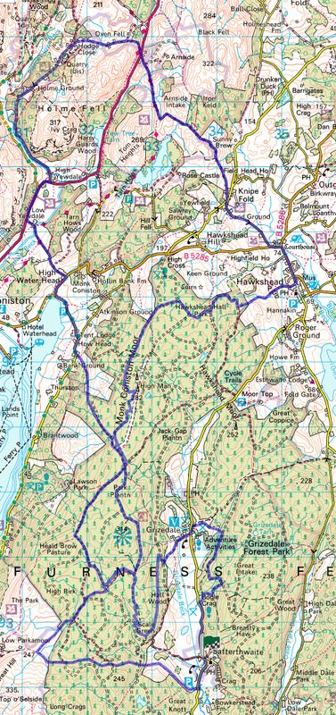 [/IMG]
[IMG] 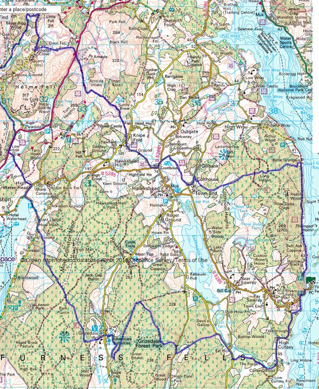 [/IMG]
Maps of routes - brilliant! (I'm one of those old-fashioned folks who still use OS paper maps 🙂 )
Thanks very much!
just get a map of grizedale and go explore (on each side of the visitor centre)
some great trails and if you get lost head back down the valley towards the visitor centre
What is your definition of "non technical" ?
There are sections which some above (on seftons map) are classifying as "easy" but that does all depend on your "skill level" 💡
Also, 30-50mls in the Lakes along and over some of those trails is a fair bit harder than shorter rides elsewhere 😉
Seftons routes are ace btw. 😆
In my opinion if you want to just cycle through nice scenery in the Lakes I'd stay on the road. Connifers aside the tracks present a degree of challenge. I would also argue that Grizedale Claife Heights aren't the scenic heights lights of the lakes
Here is my recommendation. Head North to Elterwater. You could use the bit through Tilberthwaite which is a Sustrans route. Head up Langdale and up langdale Pass. Then down and up over Wrynosse pass. Turn left through Seathwaite and Ulpha onto Duddon Bridge. The back upto Conniston on little roads.
I have ridden all of this but probably not quite in this loop
My software say 33 miles. You could easily add Hard knott pass as well. But that would add to the over 7,000 feet of climbing. But the scenery will be amazing
If you really need to see this on a map i can probably do that
That's a good shout Ampthill - if you're determined to make it an MTB route you could also go over walna scar from the seathwaite side. Good not too techy descent to coniston though you will be doubting the sanity of your route choice on the heft up.
Blawith common/Beacon Tarn/Woodland/Subberthwaite sort of area. Check it. Probably be shit up at the moment tho.
Quiet, lanes, singletrack, no conifers etc. etc.
Yeh, go on your road bike instead.
[url= http://www.golakes.co.uk/adventure-capital/cycle-guides-download.aspx?AskRedirect=true ]Food for thought[/url]
[url= http://www.golakes.co.uk/Coniston-Tour-of-Coniston-Water-the-Torver-Trail/details/?dms=3&feature=10&venue=5052091 ]More[/url]
This one will take you to Chester's for coffee & cake 😆 http://www.gpsies.com/map.do?fileId=asmvasqjcjigwmky A trip over Loughrigg into Ambleside could be added on.
Time to get mapping 😆
Thanks for all the suggestions folks, much appreciated 🙂 Maps coming out tonight!
I would normally take my road bike, but I'm heading up this weekend and the forecast is for the freezing level to be down to the valley. I'm not a fan of icy roads (been involved in a few road club accidents involving ice), so would prefer mtb if it's likely to be below freezing.
Lots of miles and hills / climbing not a problem - in fact preferred 🙂 (I live in Snowdonia!), and happy to mix up quiet lanes, tracks, cycle paths, forest trails etc.
Looking forward to it, haven't been riding in the lakes for years!
If you don't mind the odd hill; http://my.viewranger.com/route/details/MTUzMzk= (Various versions of this route exist)
Pedalnorth version: http://www.pedalnorth.com/content/walna-scar
My favourites include Tilberthwaite and Ironkeld. We take our caravan (soon to be camper van 😆 ) to Skelwith Fold from where there are lots of choices 😆
Britannia Inn @ Elterwater for meals btw......