![]() You don't need to be an 'investor' to invest in Singletrack: 6 days left: 95% of target - Find out more
You don't need to be an 'investor' to invest in Singletrack: 6 days left: 95% of target - Find out more
Anyone know what’s up with the new fencing which has been put over the end of Honey Badger in Auswell Woods Dartmoor and the track back up to Buckland? Lower is a bit comedy as you can walk round it but someone is obviously miffed.
I thought that site was a bit contentious, isn’t some of it SSSI and the rest privately owned.
Most of the people I know stopped riding there a while back.
SSSI is a relatively small strip running West from the cairns and has been extensively damaged by the planting of conifers by previous owners rather than any trails. There is an NT/WT appeal to replant broadleaf trees which is great. These fences are a way away and look like attempts to restrict access to walkers down to the river walk eg to Lovers Leap rather than protect an SSSI.
I’ve never ridden the stuff in auSewell so don’t know it, ride blackalls and son of blackalls on the way to work sometimes, just noticed on Strava that it went from being ‘the’ place to ride for the enduro crowd to suddenly nothing.
I noticed the BCU owned access to the river at Holne weir has been fenced off quite substantially, then nearly ran someone over who climbed out a hole in the hedge. I ran through spitchwick corner on Monday morning, picked up a fair bit of rubbish...
Doesn’t the SSSI cover the area around Lovers Leap and the eastern river bank?Map link
Auswell woods aka devon alps or river dart, I did hear a local rider got a call from the police after riding it a few months ago, have since heard its okay to ride again and have seen via strava people are still riding it, haven't got back there myself yet.
I don't know much but I what I do know is:
Have heard that the fence at the bottom of Honey Badger is because the end of Honey Badger exits onto private land that is not part of Ausewell. People would ride out the end of HB across this land and exit at the road near Holne Bridge. The private landowner is merely stopping people crossing their lane.
As for the fence over near Lovers leap and at the bottom of Grey Park Wood, it actually cuts through the trail with jumps on in Grey Park Wood so is potentially dodgy if someone keeps riding and doesn't see the fence. But when was here a few weeks back stripey tape had been put up as a kind of half-hearted warning.
Going back to Ausewell, no-one really knows the plans of the NT and Woodland trust, but they are planning on opening it up to the public when they have full ownership. So who knows if the trails and access to them will remain or not.
People would ride out the end of HB across this land and exit at the road near Holne Bridge
Guilty...
Ausewell Wood | National Trust
looks like they now have it and there is open access (on foot anyway). not sure what the deal is with riding..
going for a run/explore round there tomorrow morning on my way to work
As per Jambo's link, the NT area of Auswell has been formally opened to the public as of last Monday. The guy who built the trails has been in discussions with the NT Ranger who has said that publically its a no bikes woods but that it wont be actively policed. He was also pretty adamant that exiting the woods down to the road bridge isnt helping MTB'ers case.
The fence mid way down Auswell is pretty much the boundary with the chunk of woods the Woodland Trust purchased at the same time as the NT and they've put up a fence.
interestingly, loads of the segments on strava seem to have been deleted/made private.
interestingly, loads of the segments on strava seem to have been deleted/made private.
Yeah that was a ranger suggestion aswell.
how far down do they own? can you get all the way down to lovers leap etc?
so, ran down honey badger to the last fire road. 99% intact, then ran along the river where there is a gate stating no access about 100yds before where alls well comes out. ignored it, and ran up alls well, to the fence talked about above. below the fence is 99% intact, above it is covered in brash for a lot of it.
neither track looks like they are getting any traffic.

I’m not quite sure about where the fences are your referring to but wouldn’t it be nice if the NT said, ‘you bikers have been riding here for years, there’s 3 paths, stick to them, don’t build any more and we will let you be”. Wishful thinking??? The woods are more than big enough, half is conifer so that will be clear felled, there’s lots of rhododendron taking over and some woodland management will be required to improve biodiversity/ habitat of other areas etc. The MTB tracks that are there will really have v little impact on the overall habitat that the nt will be trying to conserve. I think it’s more that they just don’t like bikes.
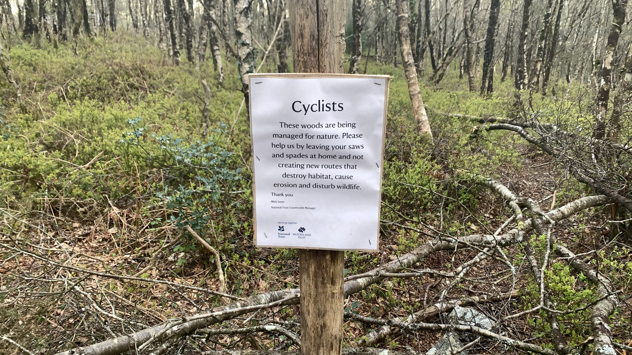
Honey badger is intact and that sign about cyclists is at the top of it. To me that’s implicit acceptance saying we know you’re here but don’t build anything else. I didn’t go right to the very bottom but I think the fence is blocking the exit out to Holme Weir because it crosses into land they don’t own. I confused that with reference to the fence halfway up/down all’s well.
Looking at the map and where I ran, the bottom half of all’s well, isn’t on the national trust owned land. And the top half has been affected by the thinning work.
Those signs look like a remarkably accepting and mature landowner. I would be going out of my way to keep them on side.