![]() You don't need to be an 'investor' to invest in Singletrack: 6 days left: 95% of target - Find out more
You don't need to be an 'investor' to invest in Singletrack: 6 days left: 95% of target - Find out more
tick
only been up Ben Nevis once but we took the path up via the CIC Hut which culminated in a fair scramble to the summit. not sure how much of that would be ridable but we had low vis and some snow up there so not the best conditions to scope therefore might have missed something.
the path that runs from the hut straight out of the valley along the stream/river looked interesting though. not massively technical, more fast and flowy. http://www.streetmap.co.uk/idld.srf?X=216022&Y=773125&A=Y&Z=120&lm=1
Ace thread. Some top routes and ideas. Gets me thinking for days and evenings out from Inverness come the spring.
Ace thread. Some top routes and ideas. Gets me thinking for days and evenings out from Inverness come the spring.
agreed - love it! it's exactly the type of riding i love & very inspiring. it spurred me to organise the trip last october (see pg 2) which i have just re-booked for spring. hopefully we'll get some good weather this time round!
Peachos
Feel free to contact me nearer the time and I may be able to help with route choice on some of the hills local to me and further afield which I have ridden.
Ben Lui is a defite goer from all the research I've done on it and from having camped on it some years ago. Boggy at the bottom but gets better the higher you get if memory serves.
Has anyone ridden off road from Langdale over to Keswick? It can be done all on Bridleway with a last cheeky route from Honister Pass summit to round the ride off.
Has anyone tried The Cobbler, Ben Ime and Ben Narnain as a lollipop looped day ride?
I'm also wondering about the munros behind Beinn Dorain heading north? Ralph Storer's Munros book hints at possibilities.
Stob Ghabar - has anyone done the ridge walk with two summits? I was looking at Walk Highlands and it looks mint. Clear, obvious path with potentially great views on the right day.
Anyone?
Anyone?
Pics would be nice if you have them.
Jeez
The list is getting longer all the time. 😀
Great thread! Sbz, Sgurr a Mhaidaidh is rideable up to about 3/4 of the way up the coire from Glen Brittle YH. It gets too rocky after that, you certainly wouldnt want to take a bike up on the ridge. If you wanted to do the two munros leave the bike at the base of an Dorus and walk up. If you were to add Sgurr na Banachdich like i did you will either have to return over the arete (very thin) or dump your bike at the junction further down the coire on the way up to an Dorus.
The most recent munros i have done by bike were the two at Loch Lochy, Meall na Teanga and Sron a Choir Gairbh. Meall na Teanga isn't worth doing and Sron a Choir Gairbh is only just worth doing, however, the Cam Bealach is one of the best descents i have done. Very bouldery and rocky all the way from the top of the bealach to the forest with only a few smoothish bits. I cant recall any waterbars on the way down. Not too sure about riding up the Bealach as i prefer to walk up the munros and ride down, so it was a push up for me (no granny ring). Im sure it would be no bother to the fit and willing.
Sanny, from the top of Scafell Pike head NW on the paths towards Great End, then down to Esk Hause then back on yourself to Sty Head and on to Borrowdale. Flipping brill descent, allthough pretty tech and a tad scary in places. Probably one for a weekday aswell. I have been fancieing COnsiton for a long while now. Was thinking up Walna Scar then along the crags, down then up onto the Old Man, before heading down the mine track. One for a dawn raid this summer
Is that a Munro?
😉
Stob Ghabar - has anyone done the ridge walk with two summits? I was looking at Walk Highlands and it looks mint. Clear, obvious path with potentially great views on the right day.
Not sure about that one sanny. Mind you when I walked it I didn't know much about biking. The ridge named Aonach Eagach on Stob Ghabar is pretty rough.
Sgurr Mhaoraich to Am Bathaich in Glencoich forest. Bit of a pull up, but there is a nifty zig - zag singletrack down the face of Am Bathaich to the environs of Altbeithe house. As for Ben Wyvis, its a classic in these here parts, just avoid weekends as everyman an his dog goes up it.
Ban More on Mull. That looks pretty straigtht forward.
Liking the idea of heading up to the CIC hut on Nevis then heading accross to the tourist path then going back the same way. That's now added to the list.
Meall nan Tarmachan appeals too. It would be a bit on offy with the scramble step down but again it appeals. A straight out and back could be good having walked it in winter a couple of years ago.
Has anyone got the beta on the hills along the A9 around Drumochter?
What about getting up onto the likes of Ben Alder and also the Mondaliath Mountains? It's not an area I know well.
For Coniston Old Man, I'd be tempted to head up Walna Scar from the Broughton Fells side then on reaching the high point cut up on the track the heads west / north west ish to make a circuit. Has anyone tried this?
Also, what about mountains that aren't munros but which offer fun descents?
Cheers
For Coniston Old Man, I'd be tempted to head up Walna Scar from the Broughton Fells side then on reaching the high point cut up on the track the heads west / north west ish to make a circuit. Has anyone tried this?
which paths do you mean?? ridden up the [url= http://www.streetmap.co.uk/map.srf?X=324064&Y=494028&A=Y&Z=115 ]path[/url] from stephenson's ground by the side of the stream - quite a nice climb but gets quite sloppy when it flattens off near the top before you reach walna scar rd.
also had a look push up and ridden back down this [url= http://www.streetmap.co.uk/map.srf?X=326239&Y=497449&A=Y&Z=115 ]path[/url], which cuts up to Dow Crag. seem to remember that being ok to ride both ways and it looks like it leads on to the top of old man.
i want to check out the area over towards Swirl How & Wetherlam though this year - has anyone ridden or walked up there??
I have walked most of the Munros in the Drumochter area and don't really remember seeing any singletrack, to be fair they are not the most fun of hills to walk. They do have some landrover track up them and over the last year or two the estate owner has been putting in a lot of new tracks both for landrover and to enable shooting parties easier access. I don't think any of the singletrack paths go right to the tops of the hills but some look like they could be fun.
I did the loop round the bottom of Ben Alder last weekend which was good fun and had some nice bits of singletrack, I didn't see any paths heading up to the summits so not sure if it would be worth heading up. The bike into the base is 10miles along on good landrover track and doesn't take long if you have never done the loop it's worth doing and on really has one hike a bike section but that doesn't take long.
If you are looking for a fun day out that is still in the hills but not Munros you can't go wrong with a tour round the hillis of Bennachie just to the west of Inverurie. Depending on the loop you do you can get in 6 very good long decents all very good and with very little hike a bike.
Another one for the list, Glas Tulaichean (1051m) from Spital of Glenshee
Glas Tulaichan can be made into a three summit round trip. When I do it, I'll post on here as it has great potential when the weather is nice.
Went and did this one (just Glas Tulaichean) shortly after posting back in november. Found the climb up from the ruined lodge hard going ... 100m > breather > 100m > breather ...
hello, can these paths/routes all be seen and marked on landranger/explorer maps or are they just the common walkers routes around the munroes. thanks
sorry if this is a novice question
Haggis
It all depends. Often maps aren't always up to date and don't always reflect what is on the ground. For example, Carn a Chlamain has a Land Rover track to just below the summit but you wouldn't know from the OS Map I have.
Wlak Highlands is a great site as is geograph for pictures of trails and getting the beta on potential routes.
Spin
You'll be the man for Torridon.
What scope is there for the peaks up there beyond what we did when we were last up there?
Also, has anyone ridden anything on the west side of Glencoe?
Not a munro but what would Goat Fell be like? I've had it as a possible for a while but yet to try it. I'm thinking carry at the top?
Sanny - long time no see.
Top thread.
Anyway - as said before Mt Keen from either side. Including it in the Fungle loop makes a fantastic day out.
Broad Cairn also goes, combined with Corrie Chash is ok, but I think a better option would be descent to Bachnagairn which would be wonderfully tech.
Mt Keen
[img]  [/img]
[img]  [/img]
[img]  [/img]
Corrie Chash
[img]  [/img]
[img]  [/img]
Must get out there again and do Lochnagar - Glas Allt Shiel
Goat Fell's a ride-n-push to the top and a fun descent which always feels a bit shorter than you'd hoped. Like Lomond, its seldom quiet, so you need to choose your time (obv easier if you're staying on Arran). I did it again over Christmas in horrific weather, sacked the last bit of climbing because the wind was just too strong and was happy just to get down!
I've walked the Stob Ghabhar loop (from the uni hut and back) years ago - I think that would be an interesting day, but from memory there are some narrow ridge sections and a steep bit of scree along the way so it would be a bit stop-start. A good one for taking the train to though.
This thread rules.
Hi - love this thread, defo the best sort of riding you can do IMO.
Feel free to shout me down but.......... I am in the process of developing a route guide and would love to get some of these mapped on my website site (you should be able to figure out the url) on the routes page. Be ace to get with a brief description, some photos then the route mapped on an OS map (I could do this) what do you think?
Obviously I would benefit from additional content but wouldn't profit from it directly.
If you would like to submit some please get in touch. Happy to
credit contributors, even hook up for some riding some time too:)
Cheers,
Christian
You're probably anticipating this, but I think that's a really bad idea. Having seen what's happened to some local trails once they became too well known, I think it's better to leave these hilltop routes to those who are likely to take a little effort to find them out. And while I don't want to sound elitist, folk who go into these mountains need to be really well prepared. Laying it all on a plate might encourage some less experienced folks to go and they might end up a little out of their depth (or height 🙂 )hitthehills - Member
Feel free to shout me down but.......... I am in the process of developing a route guide and would love to get some of these mapped on my website site
Good, point well made! If only we could password protect them.....
Arrochar Alps are a bit lumpy for the bike but there is easy access up to the little dam below the Ime / Vane bealach, then a rougher but rideable track up into the corrie. After that it's pure hike a bike. Ben Vane has umpteen false summits to cheer up the weary.. 😆
EDIT Excellent pics floki.
Not a munro but what would Goat Fell be like? I've had it as a possible for a while but yet to try it. I'm thinking carry at the top?
I've never bothered trying to ride the top but the two routes are rideable from the shoulder of Meall Breac. The main tourist path is rideable up to about 350m and mostly a push afterwards. The descent is better on the main tourist route but if you like super techy rocky steps then the descent to corrie is the one. I like it as I like the trials stuff but its not to most peoples taste.
I'm champing at the bit reading this thread and looking at these pics.
Roll on April when the days are longer and I've got some decent chunks of time off after a long winter. Will hopefully be able to add some fresh stuff to this thread then 🙂
Here's the Five sisters from the other side of glenshiel.
[img]  [/img]
cheers for that Sanny 😀 are you still heading out with the GMBC? i might need to make an appearance again sometime soon and you can show me some of these routes
Hey Haggis
I sure am. The club has moved away from epics a bit but there are a few of us still mad for damn fool adventures.
Out of interest, has anyone gone up Beinn Fhada?
Roll on April indeed though with a bit of luck, we should get some good settled days before then to get up high.
Bedmaker. Ace pics fella. What route did you take when you took that pic?
a couple of sections needed looking at first though to get the correct lines.
You've blown the onsight!
Hi Sanny
The best way i've "ridden" Goat Fell by bike is to loop round it; roadie it from Brodick pier to Sannox (good warm-up), ride SW along Glen Sannox to hike-a-bike/scramble up onto the Saddle (steep chimney with good handholds!), enjoy Glen Rosa singletrack descent back to Brodick in time for the ferry/Arran Blonde. Not as much people-traffic as the up-and-back Goat Fell path.
Did it a couple of summers ago. It's handy to have a pal or two with you for carrying bikes up onto the Saddle. Great ride though, and if time allows it's worth having a look up onto North Goatfell from the Saddle to extend it - looked like big granite blocks from where we were though...
Ross
The route when I took that pic has a fair bit of road in it but makes for a nice few hours out.
From shiel bridge, pump the tyres up hard and head up over the bealach ratagan to Glenelg. Stop for a pint.
Carry on past Glenelg, pass the brochs at Glen beag then the off road starts at Balvraid.
Follow the track to the bothy at Suardalan, head down the hillside to the bridge below the bothy. Cross the river and head for the ruin at bealachasan then hike a bike up allt a ghleannain.
The path back down to shiel is lovely then, nice and rocky. Pic taken at lloch coire nan crogachan looking across to the sisters.
A shorter version is to go to the top of the bealach then take the forestry track (NG895199)down to bealachasan, bypassing Gleneg and Glen beag.
So Ptarmigan off Ben Lomond.
Rode it with my mate Marky Mark this weekend and it is a bit of a belter. January is perhaps not the ideal time for such things but we got lucky with the weather.
It's something of a full on tech fest. There's no point at which you can let go of the brakes and just flow. Tight, rutted switchbacks, rocky stone pitching and exposed bedrock make for a lot of slow speed fun. The very top section is a scrambly carry down but then things become a lot more interesting. We had high winds and a bit of ice / wet slippy rock to contend with at the top so some of the stuff that we would normally ride got the "let's leave it for the Spring" to come back on a dry and still day treatment. No point in being a hero as an off had the potential to be really consequential. Seeing one of the Sea Kings from HMS Gannet below us encouraged the sensible hat to be worn.
As we descended, the trail just got better and better and didn't let up until we hit the trail at the shore.
Would I do it again? Absolutely and we're already planning a return trip. Is it better than the main tourist path? Hard to say. If you like tech, it's a peach but the tech is at the expense of high speed flow so you pay your money and take your choice.
Another one to the add to the growing list. 😀
Ptarmigan is a bit steep, well done! Did the conventional route last year in foul weather but it was still jam packed with tourists.
Only managed 7 munros last year as I was late to the Munro biking party. A few of the Corbetts are good too and shouldn't be overlooked. The Cobbler is decent. Not a Munro but if you must tick boxes there's Narnain and Ime next to it. We gave Ime a go while we were up there but it was crap - far too boggy. The top section from the Cobbler down to the gravel path is great fun though. Nice and rocky.
http://www.flickr.com/photos/markforrest/6750466009/in/photostream/
Link to pics from the trip up and down Ben Lomond on the lesser travelled Ptarmigan Path. Marvellous!
nice one Sanny - looks good that path, think I'll have a crack at it when we go up in May. i was expecting it to be a bit more boggy than that, but looks like a fairly substantial path.
It's definitely not a boggy path! There is a lot of stone pitching on it but it doesn't detract from the ride. The carry down the top section would be a wee bit tricky if you came via the tourist path.
Been looking at Beinn Dhorainn again. Up the main path to the bealach, knock out the two adjacent summits then drop down and head north along the next two munros to the corrie above the lochan looks like a dictinct possibility. It would be possible to do all five munros but I reckon the hike to bike ratio might be a bit too much.
Drookitmunter
What Corbetts would you recommend?
Cheers
Sanny
PS Gratuitous munro biking shot below.
Ben Gulabin at Spittal of Glenshee, Monomanach bit further East, Cairn Freachadein at Kingussie & Leathad an Taobhain in Glen Feshie.
Fizzer
Have you walked or ridden any of them? What were they like if you have?
Cheers
Sanny
Sanny
Yes I've pushed a pram to the top of both Gulabin & Freachadein. I could ride up both of them in the right conditions, track all the way to the top. Walked Monomanach, track up to about half way then a grassy singletrack to summit.
Gulabin
[IMG] 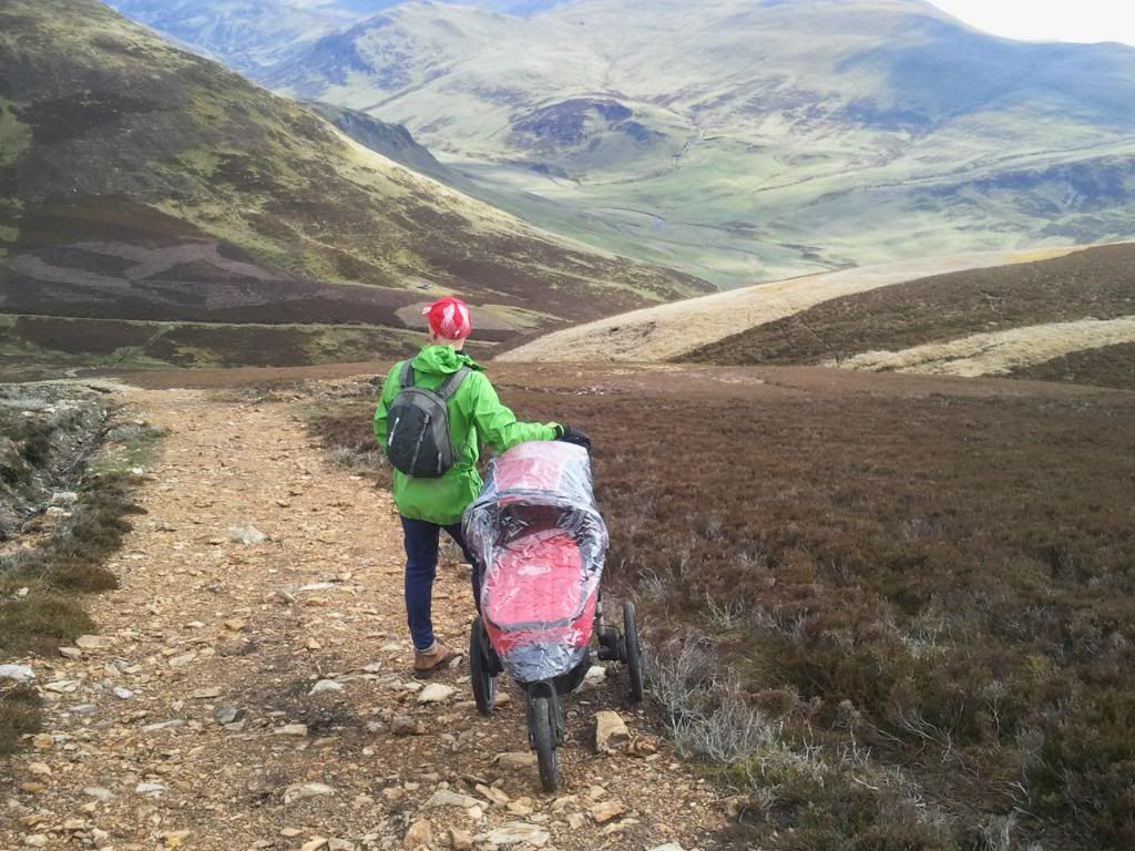 [/IMG]
Freachadein
[IMG] 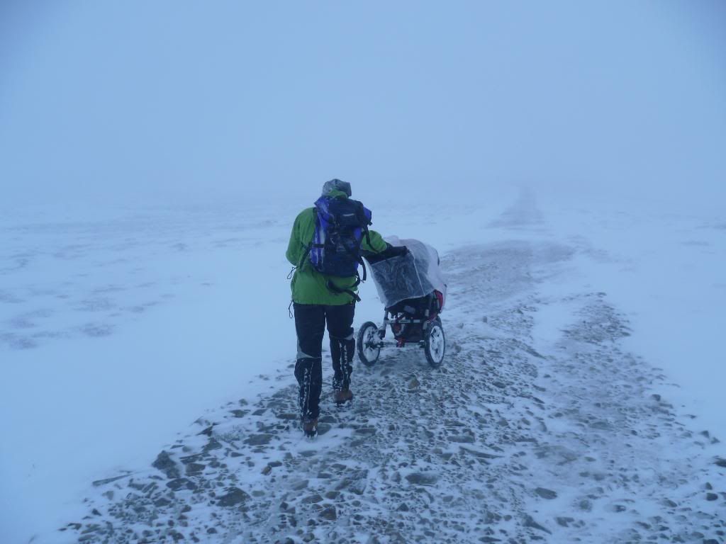 [/IMG]
Leathad has the Minigaig pass going over it near to summit. Also Carn Ealasaid near Lecht Ski slopes would easily go.
My advice is to maybe take it easy to begin with, start with a route you know you will be able to achieve
[url= http://farm8.staticflickr.com/7012/6766371159_640c889967.jp g" target="_blank">
[url= http://www.flickr.com/photos/rocketdog/6766371159/ ]365/26 26/1/12 monroe[/url] by [url= http://www.flickr.com/people/rocketdog/ ]rOcKeTdOgUk[/url], on Flickr
just thought of another - Creag Mhor above Fords of Avon, I approached from Tomintoul via Glen Avon. Bit of a carry beyond Faindouran & the descent down the Lairigh an Laoigh to Bynack Stable is ace. Did a loop from Loch Morlich SYHA. Also could be accessed from Linn of Dee. Superb remote country.
Bike by (old) Fords of Avon refuge
[IMG] 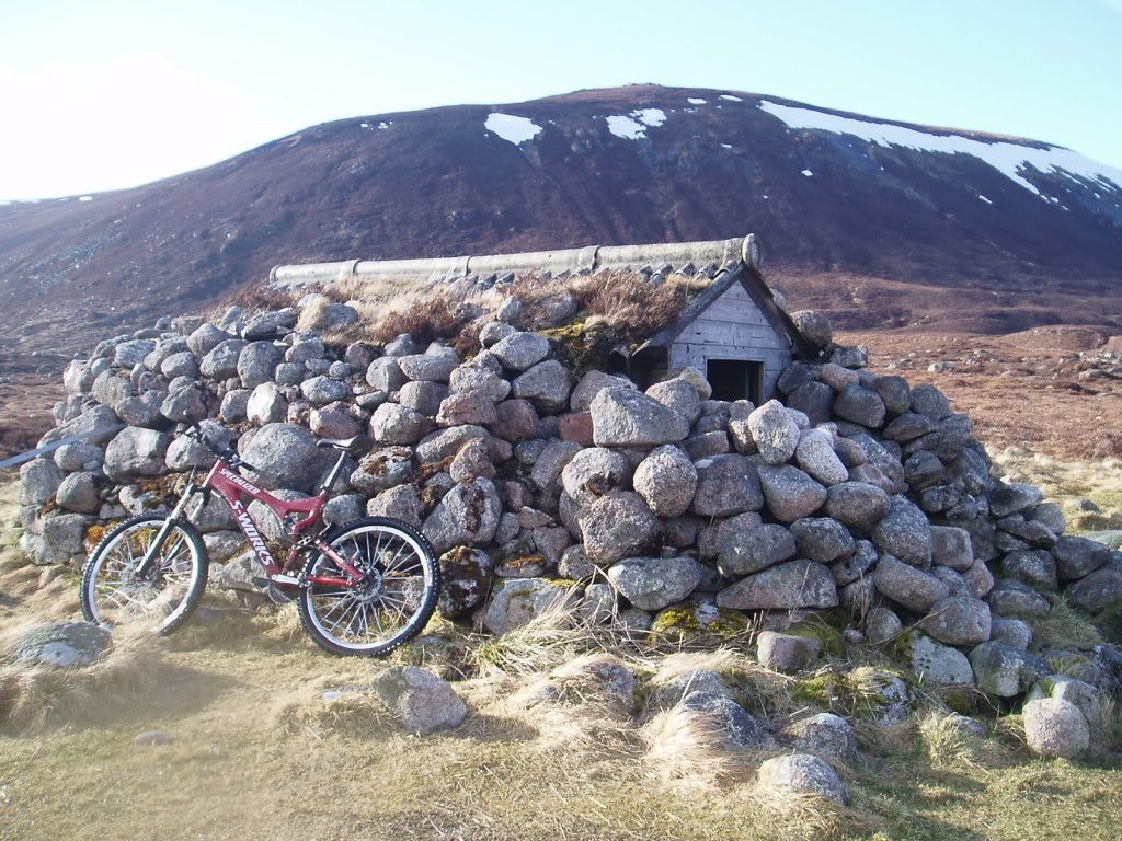 [/IMG]
Chaisgein Mor in Fisherfield from Poolewe, reckon it would go. Bit of a push beyond Carnmore Lodge but the run back down would be justifiable. (Walked it but looked promising).
loving this thread BTW I'll try to think of some more
I'd recommend Ben Vane to the foolhardy. I rode it last year and its stuck in my head every since. Steepest riding ive had the balls to ride. Had to hop off a few bits although im pretty sure i could get down those with sufficient practice. I'll be up there again this spring with a plan to explore the hills beyond Arrochar.
Great thread.
Surprised it's not been mentioned yet but Ben Ledi is a bit of fun for a morning/afternoon and easily accessible.
Can ride/walk up either tourist path or via Stank Glen.
Only descended tourist path which is mostly quite techy but all doable, not that I've done quite all of it!
Stank descent would be good but a bit boggy in places.
Also assume that Morronne is a bit common for this thread but it is fantastic.
Bugger!
That link didn't work!
http://www.gmbc.org.uk/?p=2607
Pics from Ptarmigan at the above link.
http://www.gmbc.org.uk/?p=2612
Ride report from Ben Chonzie on the other link.
Ben Ledi is a nice short ride. It's pretty quick up and down as I recall. 😀
I really wish this snow would hurry up and disappear. Not enough for decent skiing but a bit too much for some of the the high tops.
great idea for a thread
great idea for a book. I'd buy it.
feenster - Member
great idea for a book. I'd buy it.
Me too. Look at what Rob Lee has done with crowd funding.
I'm not scared off by having to do long traverses on foot, so routes like that would be good too.
man, this thread could be just waht I need to put the purpose/mojo back in to my riding. Thankyou.
great idea for a book.
..and a film for the film festivals
So has anyone got any other mountain route ideas they want to float for the collective then? I remember from doing Beinn Chabhair many years ago that the steep final descent looked promising on the bike. I recall a pathless section on the way to the summit though but it's been a while so things may well have changed.
If we expand the list to Corbett's, has anyone any others which they would say are must dos? For starters, I always rate Mealle a Buchaille up by Ryvoan Bothy as a bit of a hoot when you descend down to the bothy. Top notch views and a nice (and in places steep) descent off the summit.
Cheers
Sanny
I've just gone round Ben Wyvis (not up it). The OS map* lies about the non-existent track.
Definitely on the do not recommend list.
*and don't believe the sign either. The track showing running along the top of Loch Bealach Culaidh doesn't exist. Where it terminates at the Allt Feur-Lochain is a ruined sheiling with no signs of anyone having been near it for many years.
[url= http://farm8.staticflickr.com/7198/6878381621_88db81fa8a_z.jp g" target="_blank">
Screel Hill down the road from castle douglas has some excellent steep, rocky, technical riding from the peak; rooty fast through the forest. The wee dh course by the car park is good fun too. It's not the tallest of tops, only 350m or there abouts, but there's enough to make a good adventure of an afternoon.
I didn't have time to explore its neighbour Bengarin, could be a winner!
What's the Merrick like? It looks pretty old school and has a good height gain. I've ridden the trails round the loch at Glen Trool before and they were ace so reckon it could make for a great day out to combine the two.
Has anyone on here tried it?
Cheers
Sanny
I an surprised that this thread has made it's 4th page with no mention of CairnGorm, Cairn Lochan, Ben MacDhui, with Bynack Mor to finish off. That is a day out.
I did Merrick last year.
Not much up top tbh, mostly sanitised and agrassy/muddy path to summit.
Although I hear there's a path not marked on map, heading north..
Bennachie near inverurie is s laugh. More of the same, steep, rocky. Sneaky lines if you look hard.
Anyone done tinto hill?
Tinto would be a good evening ride. A few friends have ridden it. They all rate it.
Troutwrestler
MacDhui is a classic and a favourite of mine. A real day out.
Cheers
Sanny
Bishop forest hill between Milton and shawhead, down to the quarry. My father in law maintains that theres a distinct rocky path. Many hills and forests around Nithsdale could hold surprises.
Also skoeoch hill from Irongray has a steep rocky path built by the covenanters.
[img]  [/img]
This was the view over Auchencairn Bay from the top of Screel Hill yesterday as the sun rose.
Nice, but not a Munro, eh?
*itching with the lack of snow at the moment*
Ace pic ahhhjrene, the views are one of the many reasons I head into the mountains... and I don't care what height it is 🙄
The Buchaille is not possible to ride 100% of the way, if you fancy it you had might aswell take in the exposure and do curved ridge as either way you will be carrying.
Nice, but not a Munro, eh?
indeed
Thread resurrection time 😀
Thread resurrection time! 😀
I was up Dreish and Mayar on Sunday on a perfect Spring day. I've written a ride report with pics which you can find by clicking on the link below. Hop you like it?
http://www.gmbc.org.uk/kilbo-path-and-jocks-road-biking-the-munros/
Two big mountains, two classic technical descents and a seriously steep and tech descent that's planned for a future return trip.
Now all I need is for the weather to be good this weekend for another cheeky adventure. The Inverar Horseshoe could be on the cards. 🙂
Cheers
Sanny
ahhhjrene - i only live round the corner from Skeoch how do you get up there?
pass it all the time on the raod bike but as theres nothing marked on the OS never thought to take the MTB up it
Will
Another fine day, another Munro. Schiehallion was the option for today as a bit of overnight snow made me decide to go for the easy option over the Inverar Horseshoe. Schiehallion is a fine descent. We reached the summit with less boulder hopping than I remembered from walking it and had great fun on the rocky traverse which became rideable several hundred metres of boulder hopping from the summit. A great little ride though a bit short for my liking. Worth doing for a quick big mountain hit. 😀
I was up Schiehallion recently (walking) and thought it wouldn't be worth taking the bike past the cairn at the top of the old path.
To be fair, after the cairn, on the way up it's a carry to the summit but on the way back just as you reach the first steep section, the jaggedy boulders are very rideable. It's loose and rocky but lots of fun as you pick a line through. The summit is only for the committed but I knew what to expect so the carry was worth it. 😀
And you should be for trying that! 😛Sanny - Member
The summit is only for the [b]committed[/b]
Ha! Ha!
It really wasn't that bad. Boulder hopping on Schehallion is pretty straightforward and besides, you can't say you've been to the top with the bike unless you've actually done it!
This thread must never die!
Today I made my excuses and abandoned work to do the Glen Strathfarrar Munros, 3 of them 8)
Totally knackered now and well tanned!
After a 20 minute drive I left the van at Struy then biked the 7.5 miles to the start of the climb. Nearly froze riding up the frosty glen at 7.30am. It was rather picheresk.
[img][url= http://farm8.staticflickr.com/7130/7021241359_b93fa4ac97.jp g" target="_blank">
[url= http://www.flickr.com/photos/60407271@N04/7021241359/ ]DSCF5676[/url] by [url= http://www.flickr.com/people/60407271@N04/ ]LOVATSTOVES[/url], on Flickr[/img]
At the start of the off road. The snowy peak in the middle is about half way round the planned route - this is a big day out!
[img][url= http://farm8.staticflickr.com/7056/6875152884_f06675a4f9.jp g" target="_blank">
[url= http://www.flickr.com/photos/60407271@N04/6875152884/ ]DSCF5701[/url] by [url= http://www.flickr.com/people/60407271@N04/ ]LOVATSTOVES[/url], on Flickr[/img]
Getting onto the first top is a huuuuge slog. Pushing all the way on grassy/heathery/slightly boggy slopes. This phot is from the summit looking along the ridge where I am heading for.
[img][url= http://farm8.staticflickr.com/7095/7021262771_75091c3385.jp g" target="_blank">
[url= http://www.flickr.com/photos/60407271@N04/7021262771/ ]DSCF5709[/url] by [url= http://www.flickr.com/people/60407271@N04/ ]LOVATSTOVES[/url], on Flickr[/img]
The downhills are almost all rideable, only the odd rocky step here and there which stopped me. I wasn't trying any heroics up a remote munro on a Tuesday in March. Never saw a soul all day.
This climb ahead is onto the peak you can see in the pic from the start of the climb. I was getting tired by now and looking at this prow was a bit daunting.
[img][url= http://farm8.staticflickr.com/7216/7021269141_541826e1b6.jp g" target="_blank">
[url= http://www.flickr.com/photos/60407271@N04/7021269141/ ]DSCF5721[/url] by [url= http://www.flickr.com/people/60407271@N04/ ]LOVATSTOVES[/url], on Flickr[/img]
Looking West, very hazy now...
[img][url= http://farm8.staticflickr.com/7081/6875168452_97c112ce54.jp g" target="_blank">
[url= http://www.flickr.com/photos/60407271@N04/6875168452/ ]DSCF5729[/url] by [url= http://www.flickr.com/people/60407271@N04/ ]LOVATSTOVES[/url], on Flickr[/img]
Looking back, now that's a downhill!
[img][url= http://farm8.staticflickr.com/7262/6875170842_f73c8ef57b.jp g" target="_blank">
[url= http://www.flickr.com/photos/60407271@N04/6875170842/ ]DSCF5733[/url] by [url= http://www.flickr.com/people/60407271@N04/ ]LOVATSTOVES[/url], on Flickr[/img]
Looking down the long final descent - the loch is about half way down.
[img][url= http://farm8.staticflickr.com/7204/6875173686_df13a15f64.jp g" target="_blank">
[url= http://www.flickr.com/photos/60407271@N04/6875173686/ ]DSCF5738[/url] by [url= http://www.flickr.com/people/60407271@N04/ ]LOVATSTOVES[/url], on Flickr[/img]
After the loch, the path turns into a very washed out landy track which was an absolute hoot.
[img][url= http://farm8.staticflickr.com/7093/7021281207_a209cc8130.jp g" target="_blank">
[url= http://www.flickr.com/photos/60407271@N04/7021281207/ ]DSCF5741[/url] by [url= http://www.flickr.com/people/60407271@N04/ ]LOVATSTOVES[/url], on Flickr[/img]
A fine day out. Anyone planninig this looking for a nice bivvy spot should seek out the old lead mine about 5 mins walk from the start of the climb. It's marked on the 25000 map.
I will definately be camping out here sometime soon.
[img][url= http://farm8.staticflickr.com/7063/6875148264_508deed1ef.jp g" target="_blank">
[url= http://www.flickr.com/photos/60407271@N04/6875148264/ ]DSCF5693[/url] by [url= http://www.flickr.com/people/60407271@N04/ ]LOVATSTOVES[/url], on Flickr[/img]
The ups were 100% pushing. The terrain is mostly good so the bike will roll along okay. There are two short boulder flields onto summits where I carried the bike. This was only about 30 mins total though.
The descents are all rideable except maybe around 150M of rock field in total.
9hrs 15 mins total, including a stop on the way down to soak my legs in the baltic river.
[url= http://www.walkhighlands.co.uk/maps/map3_12ln.shtml ]the route[/url]
According to walkhighlands it is 4 munros. Bonus!
Bedmaker
You legend! I'd wondered about riding those. They are now on the list.
I'll see your 4 and raise you 7. Captain Mainwearing, my mate Donald and I decided to take advantage of the weather on Sunday and knocked out the seven munros on the Ben Lawers massif. It was a big day but a brilliant one at that. A really hard first summit and careful route choices on An Stuc were rewarded with some stunning views, top notch descents and some quality banter. The descents off of Ghlas, Lawers and An Stuc are ace.
Nice one, that sounds like a hoorovadayoot!
Ben Attow is next on the radar. Next Monday a possibility weather permitting as I'll be in Kintail with the family.
What a thread , more routes and ideas than I have time for. Ace 🙂 🙂 '
Ben Attow. There are some great route pics on Walkhighlands for that. I really fancy giving it a go.
I'm gutted only to have just found this thread, so awesome.
What about the 5th sister of Kintail? the other 4 are probably a bit too gnarly and shes not a munro but would be pretty fun to play around on and come back down by the burn ...?