![]() You don't need to be an 'investor' to invest in Singletrack: 6 days left: 95% of target - Find out more
You don't need to be an 'investor' to invest in Singletrack: 6 days left: 95% of target - Find out more
We're off to Lakes tomorrow, to follow the lakeland 200 route (discussed on here a bit) but wimping out and doing it over 3 days. Also willing to take a few route alterations if it will avoid undue pain and misery!! (and especially if it means getting to the pub..........)
Noticed on here someone said Harter Fell was to be avoided at all costs! This is on the route between Coniston and Eskdale. Is it that bad and if so is there a viable alternative route.............?
Alternatively - M (and W) TFU I suppose
thanks
Do it, you'll never forget it.
Charliemort, would you be kind enough to report back on how it goes over 3 days as I have been looking at this route for a small group of us. Where are you breaking up the ride for your overnight stops?
It's a steady fireroad climb up, a pretty tiring push/heft across a bog at the top (for a fair way) and then a decent descent into boot.
I'd go that way again as part of the Lakeland 200 as it's a bit of an 'adventure' and as the only alternative I know of is Hardknott!
We did the route over three days too. (Well, I only did the last two due to work.) Stopped at a campsite near Staveley (left a car with tents there), then at the Youth Hostel near Boot. Two big 80km days, then a shorter 40km one. We tweaked the route slightly over Claife Heights due to a fell race (came down a better descent anyway) and also cut out Stanton Ground as we were running late.
Have fun!
My only experience was running this in the Lakeland 100. Very, very wet across the top. Miserable to run, dread to think what it would be like to ride. It was so wet (and dark) that stepping stones near Boot were completely underwater!! Apart from that, it was lovely!!
Have fun!
errrrmmmmm yikes. At least it's been dry this week
Suspect the sounds of matrimonial discord and tantrum-esque bike chucking will be heard some miles away
Simwit - We are planning on Stavely - Boot; Boot - Patterdale; Patterdale - Stavely, staying in YHA's. Yes will report back (if we survive)
But we are staying in Windermere first night - vertebratetom: would we better starting near Windermere rather than driving to Stavely? And doing extra on the last day?
Dunno really. We figured two big days, then an easy one was best - like you've done.
Staveley to Boot is a big day, although it's pretty easy to shorten in the middle if you need to.
Boot to Patterdale, ditto - a BIG day, although there are maybe fewer opportunities to shorten it.
Out of Patterdale you've got the massive climb on to High Street, it's not too bad from there. And it wouldn't be too hard to bail to Windermere and miss Staveley if you were getting knackered.
I'd probably start in Ambleside if it were me and I was stopping where you are. Although a short last day is always nice...
EDIT: Sorry, that was basically no help at all!
yup that was a help - think I'll cut day 1 a bit
where is Stanton Ground? can't find it on google
thanks
Stanton Ground is one of the bits between Walna Scar and Seathwaite. (SD 223 924). The route drops south off Walna Scar, runs along a nice bit above the river near Broughton Moor and then crosses over to Stanton Ground.
You could shortcut it by dropping straight down Walna Scar, or by doing what we did and turning north from Stephenson Ground. (It'll be obvious on a map).
Hardknott wouldn't be too bad from that side as you're half way up it already - basically 10-15 mins of huffing and puffing (probably pushing with your camping gear on the bike) as opposed to 30 - 40 mins slogging across the top of harter, gettng wet feet into the bargain - the fire road bit's fine though and the descent is pretty good.
If you REALLY want a divorce start from the stepping stones across the duddon and ride the bridleway up.
Geograph.org is your friend
east side of Harter Fell:
[img] 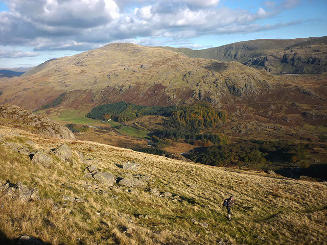 [/img]
west side:
[img]  [/img]
[img] 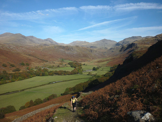 [/img]
The bottom one is the DH to eskdale the other two are footpaths to the summit. The middle ones left middle foreground is the boggy bit you'll be riding across (I think)
okay - located Stanton Ground. Yup - had my eye on that short cut
stroll up Hardknott looking appealing!! Not carrying camping stuff thankfully
Just had a another look at the map and realised I've done the BW from grassgarth so taking the fireroad up would cut 50% of the crap out...So ignore everything I've previously said and get it done.