As per title?
Thanks-in-advance
online? sure, look at http://veloviewer.com/ - they have a OS plug-in for browsers.
Free to use but donations welcome.
Yes. Very easy, in fact just this minute done it for my ride tomorrow (im old skool)
1) Export the GPX from Strava
2) Use Bing maps (www.bing.com/maps)
3) Select the "my places" option to the top left of the map window
4) Upload/import your GPX and select it when it appears in the little box (map should re-center on your route)
5) Above the map window where it defaults to "Road" map type, select the "Ordnance Survey Maps" option from the drop down. Gives you both 50k and 25k options depending on zoom level.
I had no idea you could do this with Bing, Warns. Thanks for the tip.
No probs 🙂
Nice one warns74! I guess Microsoft must have struck a deal with Ordnance Survey... just a shame you can't print OS maps using it!
I'm watching this witchcraft with interest. And shall find this Bing, and speak with him forthwith. The sorcerer that he is.
Can still happily recommend veloviewer as alternative HH - if you have the Strava data to hand. Saves exporting the GPX (and you can view other folks' routes without export).
Sign in using Strava ID. Select the OS overlap plugin. Drop it onto your bookmark bar. Whenever you see a route, can replace the rubbish terrain/satellite view with OS (or Open Cycle Map, among others).
[url= http://veloviewer.com/mapFlipper ]MapFlipper[/url]
Works as a plug-in for the Endomondo maps as well..
househusband - Member
Nice one warns74! I guess Microsoft must have struck a deal with Ordnance Survey... just a shame you can't print OS maps using it!
Well, technically speaking multimap.com did the deal with Ordnance Survey and were then acquired by Microsoft and the maps absorbed into their Virtual Earth product which was then rebranded "Bing"!
If you were so inclined, it is possible to view your route on bing maps at "full screen", screen grab it or use the windows "snipping tool" to copy the selected area, drop it into MS Word and err, maybe print it off at A3........ahem, purely hypothetically speaking of course and I certainly don't condone that sort of thing!!
[quote=booktownman ]I had no idea you could do this with Bing, Warns. Thanks for the tip.
Me neither - thanks (useful for more than Strava - plenty of other sources of GPX files).
I've been trying MapYX's new MXMapWeb service instead of using OS's own 'getamap'. The only advantage that the OS version has is that you can at least print maps off - my sub expired and I didn't bother renewing...
Bing does offer pretty much the same as MXMapWeb but for free...
Good info warns74 - was aware that Bing showed the 25k but never loaded in a GPX
kcal info on veloviewer is excellent hadn't spotted that one. How do you get it to work with Endomondo?
Good work kcal, now i can see where my routes go wrong (where i plan to go and where i actually go aren't always the same... ahem :lol:)
*doffs cap*
The Veloviewer plugin is excellent - and if you are a Premium user you can use it with your 'Heatmap' too... Bing also works, but struggles with multiple GPX overlays.
[IMG] 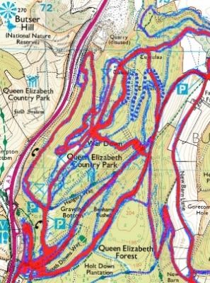 [/IMG]
[quote=warns74 ]4) Upload/import your GPX and select it when it appears in the little box (map should re-center on your route)
Hmm - I don't appear to get an import link in Chrome (and a search suggests it doesn't work in Chrome 🙁 )
@strike aside from above you can import the gpx into OS Getamap too although that's a subscription service.
brilliant tip Kcal, really useful, cheers!
Really neat being able to view the osmap within Strava itself using the Veloviewer plugin
[img]  [/img]
Thanks everyone!
Steve B -- [i]kcal info on veloviewer is excellent hadn't spotted that one. How do you get it to work with Endomondo?
[/i]
once you have the plugin as a bookmark bar button - look at route on Endomondo - hit "OS Map" button - Endomondo map view replaced by OS map, zoom gives 25 000 detail -- bob's your uncle..
@professor -- that's where I use it too, can do a post mortem on why the route didn't go where I intended, can see which junction - especially in wooded areas - was missed..
Just to say, not connected with veloviewer in any way, other than happy user, to me the fact it's all done for free (though donations welcome - and I have done and should donate more) and as a labour of love as it were is boggling really..
useful info, thanks
Is anyone aware of any issues with veloviewer? I'm not managing to get the OS map overlays on strava segment explorer...
Yes I had that on strava, but if you change the map from terrain to satellite it works! 🙂
Aah excellent thanks.
Hum - missed this first time - off to try it (I have been doing export route and import to os getamap, very tedious)
