![]() You don't need to be an 'investor' to invest in Singletrack: 6 days left: 95% of target - Find out more
You don't need to be an 'investor' to invest in Singletrack: 6 days left: 95% of target - Find out more
Two questions please...
1) If I was to hike/bike up and down there on Saturday morning, what conditions would I find?
2) Starting from Buckden, which way down?
[img]  [/img]
Thanks
Been darn saaf today, but got home and it looks like it has pissed it down. Met Office says sunshine tomorrow and dry on Saturday.
Give me a clue which is least boggy. Red or blue I'm guessing.
Short answer - a fair bit of it.
Buckden Pike can be very boggy even in dry weather. The top end of the blue variation you've marked will be bad, or at least the levellish bit over Starbotton Out Moor will be, and I wouldn't fancy bits of the path from the summit to where it breaks off the ridge. The red descent into Starbotton should be OKish. The green route up from Kettlewell will be OK.
I haven't done the path up from Buckden, although the rake itself is a solid pensioner-friendly path.
Forecast for Saturday up here is not great, BTW.
I wouldn't bother until it's frozen. The northern descent (red) you have marked is a total bog even in summer.
The purple trail is doable but pretty taxing.
The green trail is very tough heading down unless you can outsprint a sheep.
Ok thanks guys. Maybe not then.
I just have a craving for a ride from a summit.
You can ride/push up Ingleborough from Clapham and ride down the same way, if your summit fever is that strong! Couldn't say what that would be like conditions-wise.
Whernside is probably in better nick also.
I thought about Ingleborough. Never done it on a bike, but walked up and down from chapel-le-dale, over Simons and from Horton. Not from Clapham though.
I never have any luck with that hill, even mid summer I always get pea soup and hail on the top!
Oohh, Park Rash is one of my favourite road climbs followed by that looooong descent into Middleham.
You can ride/push up Ingleborough from Clapham and ride down the same way,
Of course, I meant from Ingleton - that's the only BW.
It's very wet going south along the ridge to the memorial & a lot worse down to the Walden Road BW - masses of deep bogs to negotiate. The top section of your blue route will be the same. Best left until frozen, then it will be a lot more enjoyable
Conditions at the momemt are worse than this photo
[img]  [/img]
For a route with a bit of a summit and mostly all weather tracks in that area, how about boss moor, Bodley and The Weets coming back via Winterburn?
The BW down from the Weets to Winterburn is not entirely pleasant at the moment. I rode it last weekend, and didn't really enjoy it. Rideable but the lower half of it is 'picking your way down' territory - even on some of the constructed 'all weather' singletrack BW, which is in really bad shape. The one down to Calton is probably holding up better, although there is a bit of a bogtrot for 1/3 of a mile or so near the bottom.
Boss Moor will also be minging at present!
I think we did all of that a few weekends ago (I wasn't map reading but 99% sure it would have been those tracks marked.
From Kettlewell, we went up the green to Cam Head and down the blue to Starbotton (not too boggy)
We then went up the red from Starbotton to Buckden Pike (VERY boggy between Starbotton Fell and Buckden Pike). The descent off Buckden Pike to Buckden is very good though. Not too boggy with some challenging steps down from the Pike and then a downhill blast with loads of sharp waterbars to hop.
We then went SW from Buckden over Firth Fell - Haw Fell (boggy hell of a hike-a-bike) and finally back to Kettlewell over the path in the extreme SW corner of your map (not too bad a surface and a good blast down into Kettlewell)
Thanks Pennine, that photo is the final nail in that plan.
That's really useful Ecky thanks. Only option for the pike seemingly up and back down the same way from Buckden.
I'll have a look at Ingleborough this afternoon...
Very tempted...
With my usual disregard for authority (in this case, the people who know what they are talking about variety), the view from the top of Buckden Pike today:
[img] 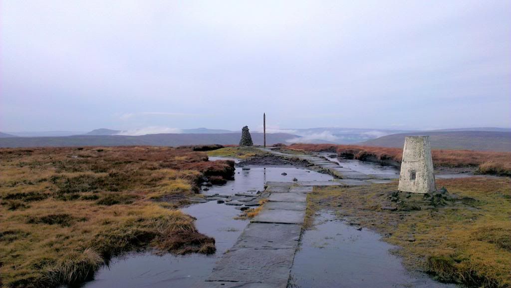 [/img]
Actually the descent was great fun. 90% was grin-inducing and really fast. One long stretch of bog in the middle. Initial plan of carrying speed across the top of it came to a crashing end with a drop, into a bog, stop and OTB. The rest was negotiated more carefully, with the occasionally off-camber scoot. Absolutely filthy at the bottom, so after a quick spin over to check out Horse Head (wet and mossy), a wade into the river for a bike bath was necessary!
Which way did you come back down?
The way I went up, most northerly line on the map. Up the Rake.