![]() You don't need to be an 'investor' to invest in Singletrack: 6 days left: 95% of target - Find out more
You don't need to be an 'investor' to invest in Singletrack: 6 days left: 95% of target - Find out more
And how easy is it to follow the route without having done it originally?
Thinking of taking my son there tomorrow for a ride, but don't really know any routes other than the FODCA trail....
Ben
Most are there but they're not waymarked.
Ah. Well maybe I'll buy a map and make it up as I go along....it's been a while since I did something like that.
Thanks!
Just follow your nose and find some nice trails. If you start from the cyclecenter and don't cross any roads you'll stay within the same enclosure. You can't get it wrong!
You can't get it wrong!
Ha ha. We'll see 🙂
I've been trying to persuade him that FOD is a bit too far away and too muddy, as is the Wyre Forest and that we should head for the Malverns - even though it'll be a Sunday.
But he's been on about going there for months so I might as well get on with it - at least it'll keep him happy.....
went over there today, I do different bits of it several times a week,
FoD is quite dry and fast at the moment, due to winds drying out the track and frosty ground,
I have put on this map what I know, in a lovely turquoise,
[img] 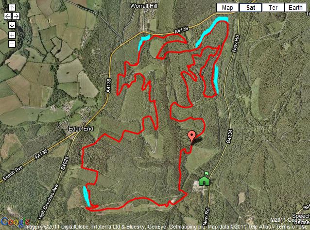 [/img]
bottom left, technical downhill, ruined due to loggin
top left, some problems due to logging, but passable,
top right, muddy due to logging tracks, but might be dry now,
also (not marked this one) the technical bit across some scrub land before the start/finish, has also gone due to loggin
image from http://thefod.co.uk/#/enduro-trail/4545175750
Thanks AMT - most useful!
The final long downhill from the bottom left corner of the map to the bottom right coner of the map at the bottom of hill is also shut/mucked up with logging as I found yesterday 🙁
The good news is that after the harvesting has finished, the route should be re-instated and waymarked later in the year 8) The details have been done, a trail builder appointed and contractors lined up so, unless something very drastic happens in all the proposed cutbacks/sell offs it should all happen.
It's going to be a Blue Route though. Which is smooth, non technical tracks, aimed at intermediate riders, families etc.
Back On Track (Rowan Sorrell etc) have started the other parts of this development, the short technical sections on the Family Trail, so looks like there is no probs with the money situation. There will also be a bridge over the road from the cycle centre to the family trail.