![]() You don't need to be an 'investor' to invest in Singletrack: 6 days left: 95% of target - Find out more
You don't need to be an 'investor' to invest in Singletrack: 6 days left: 95% of target - Find out more
Hope everyone’s ok and thoughts are with everyone up there but Yep gutted!
We were up there this time last week getting some miles in and saying ”hope it’s not this hot on the day”. The ground was very dry.
If it’s cancelled and not rescheduled it’d be good if the entries can just roll over to next year?
Good luck to all involved
Cheers
Steve
That looks a tad moist, hope everyone's OK.
I feel so bad for them, the amount of effort required to set it up only for freak weather to ruin it.
Hope the locals are all safe too, those videos look terrifying.
There's been a suggestion of donating refunds for recovery of the area. Given how much we invade the village, could be good to help out.
English summer.....
Utterly pants news.
It's a really big thing to get this many people in the dale, a proper showcase for an area often overlooked.
Looking at the forecast it looks like they're in for more today - how demoralizing 🙁
Amongst other areas in the Dales The Dales Centre and the Ardrock organisers have just been on bbc news.
Very sad for the area.
Steve
Absolutely horrendous. Hope everyone is safe.
Don't worry - the world leaders are on it.....ahhhhh perhaps not.
Some shots here - http://www.richmondshiretoday.co.uk/photos-flooding-in-swaledale/
I've heard on the grapevine that there is the suggestion that camping fees could be donated to the local community rather than refunded?sounds like a great idea..
Lordy. I was up there a few years ago, I was shocked/impressed/surprised how high up in the trees the signs of flood water were - grass, wool and rubbish snagged on branches next to the river. And that was in a normal year. Good luck to everyone up there getting sorted again.
You know all those spring time posts where people say "just put summer tyres on, it'll be my fault when it rains now."
Think I've trumped them all by being worried about lack of water; 2 days later I've flooded the valley taken out the bridge and cancelled the event. Sorry guys.
With all due respect to the local residents who may have actually lost their home/livelihood rather than just got their tent and shoes wet; the prospect of this storm being on Saturday during the race and the camping field full of thousands of tired drunk people being submerged and the roads washing out on Saturday night could well have proved fatal.
Firm crowd/rider/Marshall favourite the red lion badly hit also... 🙁

Just seen on an Instagram post, the unmistakable tall bloke that is Stu from the Dales Bike Centre, who it seems is also a retained firefighter.
Helping out to sort other people, whilst his own business is under water in thr background.
I hope they recover OK, they are a great bunch who do great things.
Come on folks we need you to visit Swaledale, the Dales Bike Centre is open for the best coffee and cakes in the dale. Many other business have got themselves clean up (sort of) and running. The trails will be wet for some while but visitors as things get sorted are welcome.
I am not related to Stu!
We're planning on staying up at Reeth from Friday for a week and I might take my bike. What trails are rideable up there? Can you ride any of the Ard rock routes or is it all private land?
I'd double check they are open first!
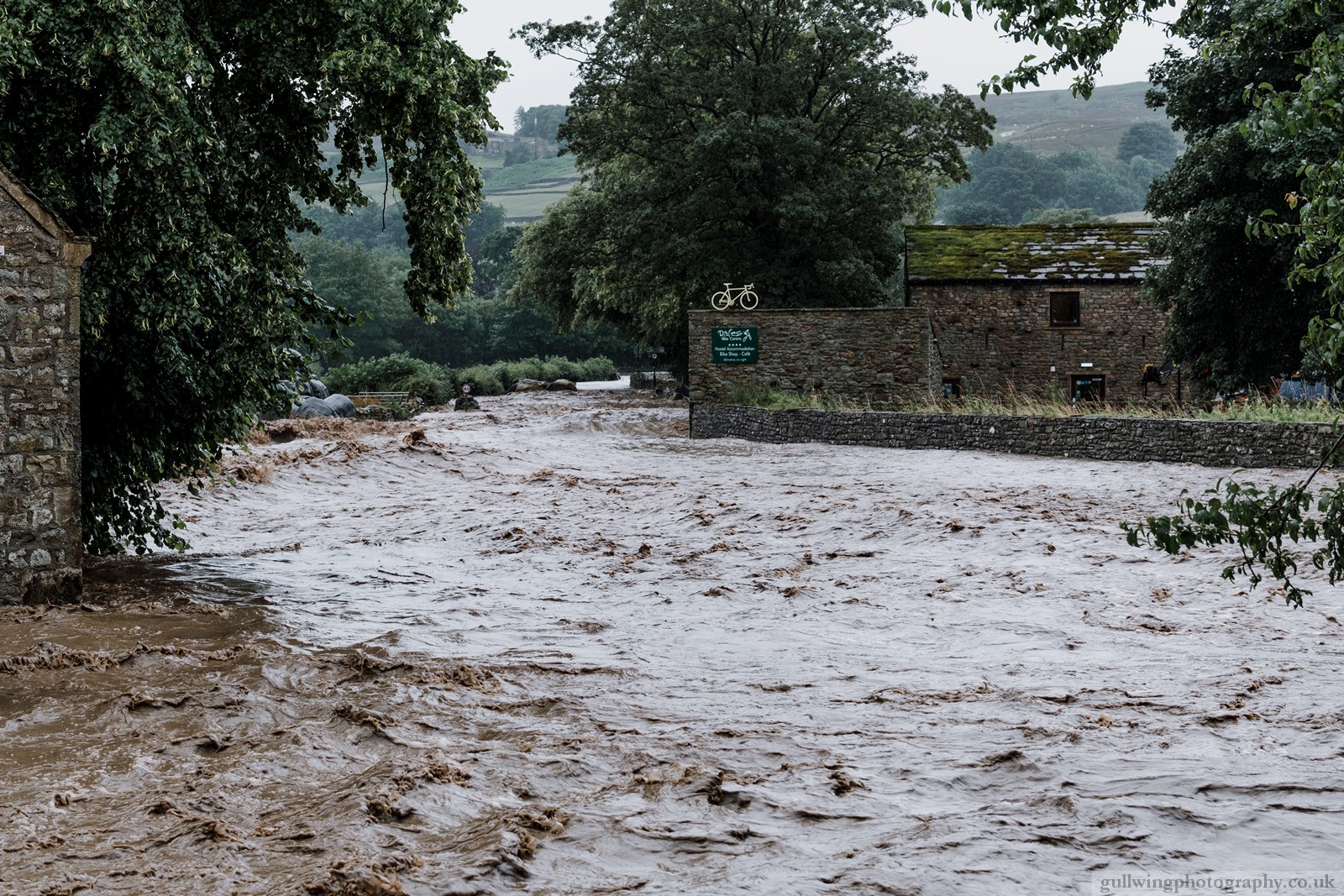
Thats the back of the cafe and their rental bike store 🙁
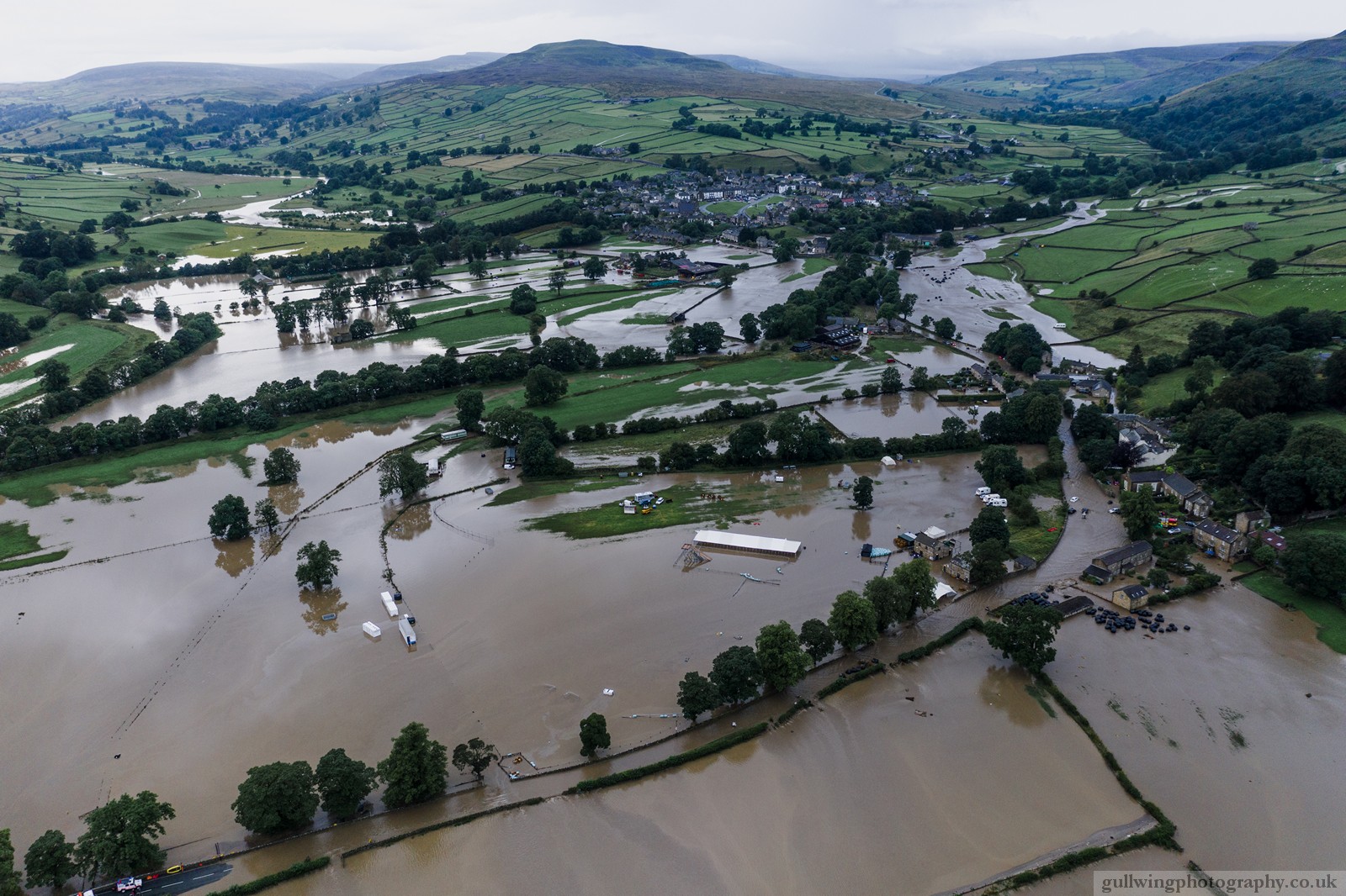
And another, that's the camping field, showers and Stage etc all setup for the weekend. Gutted for them! I have family who love just off to the left at the top of the hill, apparently it looks loel a war zone.
Those are a few days old snotrag. It normally (I get this isn't normal) clears very quickly up there. It'll still be sodden but not underwater by now, clearing up will take a while though but it's surprising how quickly things get back up and running.
Can you ride any of the Ard rock routes or is it all private land?
The stages are largely on private land, there's plenty of bridleways up there mind and I imagine a fair few will have survived reasonably well. Obviously expect it to be wet mind and take it steady as you've no idea what's washed down hill (I've seen lumps of rock the size of small cars dumped innocuosly half way down a hill by floods before), especially in the valley bottom.
I imagine a fair few will have survived reasonably well.
According to FFJA on the other thread, the BW track from Storthwaite Hall to the Red Lion at Langthwaite no longer exists in places, so any route that runs alongside one of the becks might involve some improvising.
The track down into Grinton past the keepers house has gone and is impassable. Its now the beck.
I'm not surprised at the track from Storthwaite Hall going, it was almost at water level in normal conditions.
The track down into Grinton past the keepers house has gone and is impassable. Its now the beck.
Which one's that? This one? http://streetmap.co.uk/map.srf?X=404612&Y=498331&A=Y&Z=115
I'm presuming it's the BW further back up which joins the road on a small bridge over Grinton Gill.
I've ridden one of those tracks but can't remember which one! Cuts across a field and down through a ginnel.
According to FFJA on the other thread, the BW track from Storthwaite Hall to the Red Lion at Langthwaite no longer exists in places, so any route that runs alongside one of the becks might involve some improvising.
Yeah, anything in the valley bottom will probably be gone. Up tops should be fine by and large though I'd think. I imagine a big chunk of the route between the red lion and frem edge had probably been, erm, cosmetically altered. Not sure if that's the one mentioned above.
That's the one. It floods regularly but nothing could stand that amount of water and large boulders being smashed into it.
@dangeourbrain - yes, it's the track in the valley bottom after you've descended through the old quarries having come over from Hurst. Here - http://streetmap.co.uk/map.srf?X=400759&Y=502178&A=Y&Z=115
No idea why, but I was thinking langthwaite was t'other side, for some reason. When that had been mentioned I was thinking of the Riverside bw from low row bridge. Doh.
@martinhutch Your are right the bridleway thats gone is the one that crosses Grinton beck at Vicarage Bridge (next to the keepers house).
There is no track at all with the two houses next to it have no access. The drop into the beck is considerable. Every one of the beck crossings above Grinton is in a terrible state.
Some mountain bikers have already decided the closure does not apply to them. Being polite while your are trying to get yourselves connected to the sewer system again has been managed but it does make you grind your teeth.
Some mountain bikers have already decided the closure does not apply to them. Being polite while your are trying to get yourselves connected to the sewer system again has been managed but it does make you grind your teeth.
Sigh.
Any other notable damage to the BW/trail network above Reeth? Was hoping to get up there in the next couple of weeks but there's a fine line between being supportive of the local economy and being a total PITA to the locals who have enough of their plate already.
I'm in Reeth at the moment. Spoke to stu at DBC yesterday and he said don't bother going up the edge. Advised heading over Harkerside instead. I'm planning on doing that tomorrow with a bit of luck, only for a short couple of hours blast. I'll report back. It's currently raining/thundering, there was a lot of rain last night, but no one seems to concerned about it, the worst has happened.
The volunteer effort is amazing to see, so many people chipping in re-building walls etc'.
Rode out of the Bike Centre today (as usual). The cafe and shop are open as usual. It's amazing how fast they have been able to turn things around.
We rode up through Grinton towards the YH before peeling off right (Hargill Lane) then picked up the track that heads back to Harkerside across Grinton Gill Trib (Grovebeck Gill) and then back down the track (we call it Vomit - Harker Mires) down Swale Hall Lane. There has been a fair bit of water down there so plenty of rocks and ruts to tackle. Would be pretty unrideable the opposite way up.
We then picked up the Swaledale trail - Low Lane Track. Road is fine but the trail is chewed up in places. Nothing a MTB can't handle but would be pretty sporty on a gravel bike. Evidence of some land slides higher up.
Gunnerside was pretty quiet.
We climbed up to white hill up the road through the electric gate. No real evidence of any heavy rain fall. We then took the decent back down to Gunnerside (from Barf End). Great run no issues. A quick tab along the Reeth road and a climb up the Low Row/Langthwaite road. At the ford there was clear evidence of plenty of water having gone through. Big boulders and slices of road moved. After the ford we climbed the road (super steep bit) and picked up the track that heads down to Raw Bank/Arkle Town. Again all good.
However from Raw bank it is clear to see that Fremington Edge in its entirety has taken a beating. Plenty of land slides evident that cut across bridleways and foot paths. The low bridleway (transition Ard Rock Stage 2) will be wiped out in parts and is best avoided. I suspect that from what we have seen (from a distance) that anything on that side should be avoided until landowners and park rangers have a chance to check it out.
Harkerside, Reeth High/Low Moors, Gunnerside etc are good to go.
The landslides get worse the further you go up Arkengarthdale. That area had it worse, rather than western Swaledale and of course the water carried on down to do the damage in the Reeth and Grinton area as well as the huge amounts of water that was coming off the hills there. OH and myself went over today to help out. We got assigned to delivering supplies to homes affected by the flooding. We've been to remote houses in Arekengarthdale that I didn't even know existed despite living around here for 50 odd years. We went to one old guy living on his own, really quite high on the hillside beyond the CB. This was a place that you would never imagine being flooded because of it's elevated situation. But sure enough, the water had been right through his house. We also visited Rowena at the Red Lion in Langthwaite. She showed us into what was left of her home. The devastation is unimaginable. She was very lucky to get out alive.
Got some route advice from Stu and headed out this afternoon. Started by heading out on the road that leads to Langthwaite, then over the bottom of Calver hill to do Angry Man descent. That was all fine and dandy.
Came back along Harkerside and then up the bridleway mentioned above, Harker mires. That is massively loose and rutted now. Up on the top it was fine. Headed over towards Cogden moor, there's a bridge out here. Now, either some rocks landed very conveniently or someone has placed some stepping stones down as the Gill can be crossed on foot.
Then did the bridleway that heads down to Cogden Hall. But, I found signs saying path closed. If you are stupid enough to ignore these signs, you'll find yourself cut off at Cogden Hall as there's another bridge out!
I'm glad we visited, we've spent a few quid on the local businesses and spoke to a few people. They all say the same thing, the village is open and people need to come. They all remarked on how quiet it is and the last thing they want is people to stay away.