
That map above. Ride straight across the road at dead woman's ditch car park and into the woods. Drops down in a gully. Opens out just before where it meets concrete block.
and thats the rocky horror #2?
so rocky horror #1 wouldn't be hit the way i've been going from narnia -> sharki+jambos -> mid way down chimney?
http://www.trailforks.com/trails/sharki--jambo-s/
Never heard the one by dead woman's ditch called rocky horror.
The one by triscombe is the bridleway.
I think i get where #1 is now.. its the second forest path/bridleway one you cross if you do narnia then sharki and jambos? all places i'm about to explore 🙂 i've not done the dunca's secret passing/puddles/full chimney route yet, or "the bone yard" (which i think I saw someone higher up to the right riding down when I was crossing one of the roads down n+s+js)
the DWD ref for #2 I pulled from one of dibbs old posts so hopefully he'll be back soon!
the 'new' #3 one is what someone called it on strava, the northern descent from between higher hare knap and lower hare knap that drops you end the end of somerton combe
Another one (No 4?) used to enter the woods somewhere near the R in Robin Upright's Hill, but I haven't ridden it in the best part of 20 years and what was a "horror" on a rigid bike with canti brakes may not be much of a problem now.
thats excatly what your OS ref put #2 dibbs cheers 🙂 (still 3! phew!)
so there are a handful of rocky descents off/around robin uprights hill ..
going clockwise..
- concrete block
- DWD one on the map (probably!)
- rocky horror #2
- the other track running down into robin uprights
- old devils galloping path
I thought these trails were all Secret?
They will all be 4" wide at this rate 😉
truth is.. triscombe aside - there aren't enough people riding anything that isn't in the guidebooks for that! 😉
north of the DWD/CPG road I rarely see people in places other than the main ridge track, weacombe/holford edge/ladies edge/stert+somerton/smiths/higher hare knap/frog (either one) and the upper great bear crossing (why!? :))
if my obvservations and strava are anything to go by.. concrete block, slaughterhouse, bin combe, willoughby cleeve (QQ aside) are only used by a handful of riders. i certainly don't see many off those main routes in the first list.
i often see the same 10 or so faces over the course of a months riding, and a similar number of people i never see again, but i do try to mix it up and have a healthhy amount of new (to me) ground under my tyres
... think I may have said this before [ahem] but it is possible to go riding without strava and to ride for a whole day at the same time as other people and amazingly not see anyone.if my obvservations and strava are anything to go by.. are only used by a handful of riders. i certainly don't see many off those main routes in the first list.
What I liked about all the trails on the Qs from riding them over many years was that people explored and found them and well you know, just rode them. Only now there's the internet and pics and maps and strava an' all -
They will all be 4" wide at this rate
Canopy is the new Knottie, only with maps & descriptions for the masses rather than the nice pics of bikes & posts - I claim my tuppence 😉
You don't remember knotties spider maps? They were the best.
In my misty eyed reminiscence they were more 'artwork' with vague 'directions of travel' .. 😀
love em 😉
Canopy is the new Knottie, only with maps & descriptions for the masses rather than the nice pics of bikes & posts - I claim my tuppence
ohh shit.. if you saw my fb + strava ride pics... 😡
'every week a peak' n all that!
got a bit bored of bikes n posts now though.. my last strava ride picture was of my kittens?
btw if i hadn't been posting pics like that on fb I wouldn't have two old friends riding with me regularly now at all. it helps get people start riding which is great.
... think I may have said this before [ahem] but it is possible to go riding without strava and to ride for a whole day at the same time as other people and amazingly not see anyone.
of course! until i got my HRM strava (and before it mapmyride) was for post ride analysis of where I got WAY lost! turned on at the start, tucked it in my pack and unpacked and uploaded at home.. and reviewed where i went.. sometimes drawing shapes so i could find them in the traces.
fact is though. strava's stats for segments, and their global heatmap clearly show that people favour the routes i listed. even if 30% of riders used strava, the proportions still matter. (fact is 90+% of people I know use it..)
What I liked about all the trails on the Qs from riding them over many years was that people explored and found them and well you know, just rode them. Only now there's the internet and pics and maps and strava an' all -
i still found a bunch of stuff all on my own with an OS map, or just going another way to avoid people on horses etc. those accidents led to me googling and asking for more, and the likes of sharkis old posts on here helped find a group of people who've been there and done it, and are still doing it!
i'm a ex-skateboarder (only stopped 3 years or so ago properly) and i used to know every skatepark and small town skatespot within an hours drive of taunton. every weekend ,and some evenings we would pick a string of random towns/villages and target every school, industrial estate and likely town centre buildings looking for "somewhere good". the M.O is still the same I guess!
get out explore, have fun. 😉
Great write up here chaps. Must make a trip there soon.
Unexpectedly back at the tox tomorrow after 2 cry off tomorrow's trip elsewhere (one ill, one out tonight chasing skirt).. The remainder will be exploring Triscombe and showing my mate down Narnia & s&j's etc.. If anyone's about - I ride a dark blue Santa Cruz Full Susser - say hi!
Btw I was hunting for other knottie spider maps , looks like he hasn't posted for a while but I'm sure I saw him and his son in the spring
Rides road mostly these days.
Canopy as you know all the names what's the (newish) trail next to the chimney called? Steep loose switchbacks.
I'm only just starting learning my way round great wood & triscombe but I think that ones called witches cauldron
Learned that from this video which does Narnia and s&j's to mid chimney before going over into it instead of left at the sign?
That it?
I still ride the Qs .....
hi knottie 🙂
just having a pre-ride coffee before heading off to grab a mate and head on up!
what are you riding these days? i'm sure we've said hi at least once, if not a few times!
Show us a spider map then 😉
I did a bicknoller post photo when i was up a few weeks ago
[IMG] 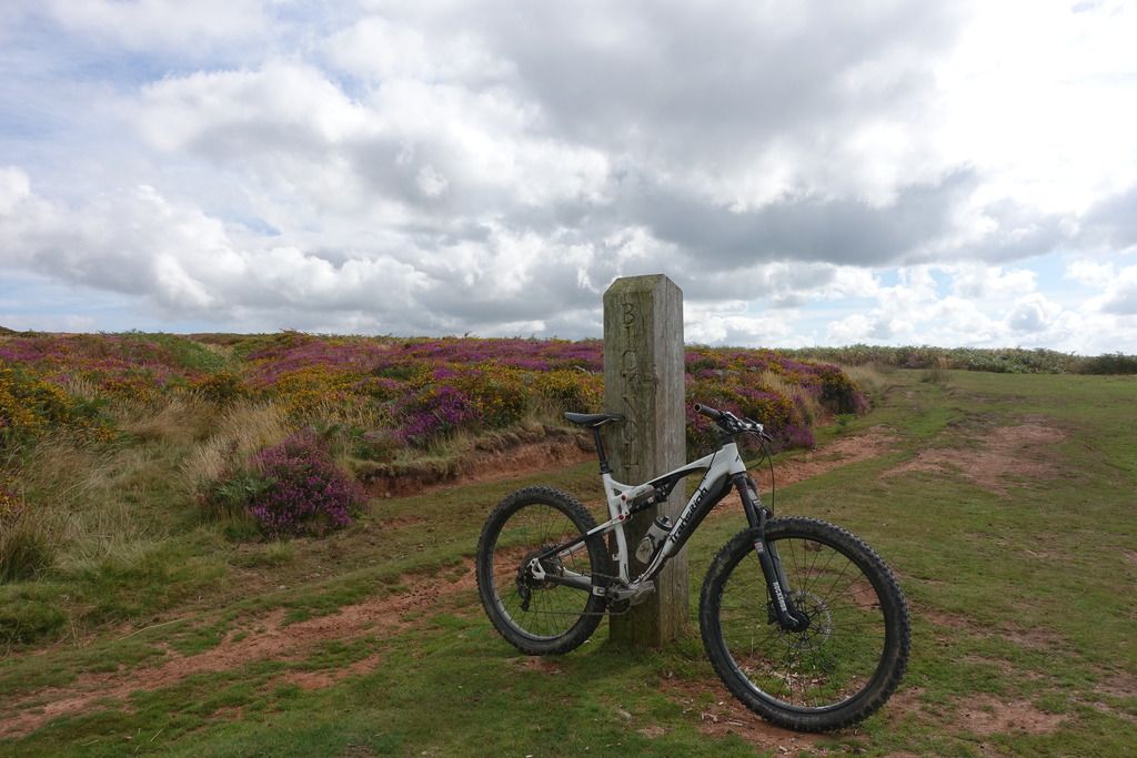 [/IMG]
Didn't recognise most of the top of that video until it popped into the gully.
That new section off the chimney looks better than the xmas tree line that used to be accessed off that corner.
Didn't recognise most of the top of that video until it popped into the gully.
i think i read it got felled/replanted a while back? certainly looks very different from the bit in quantocks sessions video, the gully was the thing that made me recognise it in that too. the sign by the gully in the newest video says something like "trail changed ahead for safety".. there's a similar sign at that point where it crosses the chimney saying the trail exit there has changed, they turned the chimney exit right at the bottom so the trail doesn't come straight out and scare people but and runs along side the road now instead, spitting people out parallel
for funs 🙂 almost up to date pic, bike has dark blue pedals now though (and little mud guards)
[img]  [/img]
Yep that's the one actually starts from the double track just along from the start of chimney.
Proper gnarly trail at speed
The gully now has the choice of the old or the newer trail to the right.
You could join the [url= http://www.mbswindon.co.uk/mbs-quantocks-ride-oct-2016/ ]MB Swindon[/url] lot on thir Quantocks ride at the end of the month. They may be able to show you some new stuff or, at the very least, introduce you to some like minded folk.
ta. not sure i'll keep up! did 20 miles & 3000m (900m) elevation today, which is rare (Defo getting fitter!).. Did actually steal some locations off one of their routes for today. i'll do that after 😀 😀
did bits some around great wood/triscombe today including.
- finding (not doing!) the' triscombe gap thats in all the videos.. its a [u]lot [/u]bigger than it looks on video!
- narnia + sharki+jambos + lower chimney
- dunc's secret passage, puddles, sams trail / full chimney
those rocks in the upper chimney must be nasty as hell when wet!
- came UP what i assume is rocky horror 😉
took my mate over to somerton and did bincombe on the way back, somones cleared the downed tree i was going to try move. woop!
Yep that's the one actually starts from the double track just along from the start of chimney.
Proper gnarly trail at speed
The gully now has the choice of the old or the newer trail to the right.
might be the one that now has a sign on saying its been closed off by the FC? only saw two trails off that side.. one was too far back to have been it as it was where sams trail spits you out
*3000ft 😉
not found anything that suits our style of riding much on the south side of cockercombe road in triscombe so far, which is to be expected as its mostly DH stuff. don't really know where to look. but i think we're more into 'natural' trails / singletrack than man made jumps and berm fests 🙂
i'm still exploring 🙂 had a weekend where everyone bailed due to the weather or previous weeks OTBs etc..
it was soggy due to the previous days rain but I finally did the DWD to holford combe route, old devils galloping for the first time in 2 years, I went 'up' the frog singletrack, and did "enduro stage 1" which is south west of DWD accessd via a small gate and crosses a fireroad (i'd always gone down through a track 1/2 east with a stile and dropping to the fireroad,and doing another descent to ramscombe) and explored behind dowsborough a little. even got to try out my folding saw for fallen tree that was blocking a track and couldnt be tucked any other way
whats left on my 'todo' list right now..
- heading from the fireroad at ramscombe over to st davids well (narnia area) there are at least two trails down (i think) if you go rights at the top of the first climb and there is the "mini chimney" on the way back from the same point in the other direction. so thats 3 for me to find.
- learn more of triscombe
- the farm descent near wills neck
- theres another trail that runs off of higher hare knap and drops onto 'horizon' further up from the frog singletrack ( https://www.strava.com/segments/6951301 )
- farm descent near wills neck
- some bits around cothelstone my mates found, which i've done very little of on foot
and when i'm really bored..
- behind combe house hotel theres a track.. i know the 'straight over' lower hare knap, and the track left, just never been right
- exploring what happens you go go 'left' after smiths, mainly just looking around that LHS side of smiths as you look down from beacon hill (i already did the deer park section and perry combe..
that'll keep me busy over winter
found an old post by sharki mentioning a descent called "half hitch" aka knotties trail..
http://singletrackmag.com/forum/topic/of-chipps-and-the-quantocks-stw-forum-ride/page/2
any idea where that is?
no idea where half hitch is and I think I probably went on that ride.
saw this earlier. some frog combe, stert combe and bin combe on there.
always been jealous of their house at the bottom of cockercombe.
nice video . i'd love to live anywhere within a 15 min ride inside the main core of the tox. growing up had a schoolmate that lived on the edge of adscombe and used to stay there sometimes.
here what should be an easier one.. a post by sharki just reminded me.. which bit did people used to call "the esses"? my mate says his cousin took him down it 15-20 years ago and he has no idea.. probably around triscombe/great wood?
ridden a few new bits from the wishlist
- bone yard. a man made technical trail parallel to narnia with lots of small jumps.. too much for me, but its nice to be in narnia and see someone higher up on the hillside coming across it
- two trails that run from up above quantock combe down onto the fireroad that leads to st davids well / rocky climb up towards narnia/bone yard. the one that comes out nearest the climb is the better one
- trail that is known as "mini chimney" that runs south to north down up above the higher ramscombe fireroad - definitely my favourite of the new batch by far
still can't find what the "esses" is, or know what knotties trails is/was..
this weekend [i]might [/i]be my first solo one for a while, if it is i'm going to explore around smiths as there seem to be various interesting looking bits on the satellite imagery
What are the trails like at the moment canopy? Aiming to be moved in within the next fortnight and got a week before I start my job so hoping to sneak out at some point...
hey 🙂
didn't make it out this weekend, for the first time in months. week before last the stuff around great wood/triscombe was starting to get slippery, but nothing too bad.
in general the quantocks dries out really well, there a few places that get boggier, especially the lower parts of combes.
you got any idea where you'll be heading out from and is there anthging you really want to ride? can try help with a rough route for you to follow 🙂
btw although strava is good for pre-ride/post-ride looking at stuff, when you're actually out ther the Trailforks app (by pinkbike) is the best to find trails by
wow, trailforks looks pretty powerful!
Thanks for the route offer - it's the Cothelstone area I'm interested in exploring at the mo. I'll be riding in and out from there to get onto to the main trails, so be nice to find a good descent from there towards Bishops Lydeard before I hit the tarmac home.
I live in Lydeard and I've been riding the Quantocks for more than 20 years, give me a shout if you want a guide for the basic layout of the place.
Thanks Dibb. Have ridden loops out of Nether Stowey when on holiday, taking in Slaughterhouse, Smiths, Weacombe, Stert & Somerton and finishing with Bin Combe, but will be coming in from Halse so at the opposite end (same end to you presumably?).
wow, trailforks looks pretty powerful!
I might just happen to be the regional admin for the quantocks too. 😉
but its great because its open source, anyone can add/alter/adjust trails. (like strava, but democratic!)
I put some nice pics on the frog combe singletrack page the other week.
Thanks for the route offer - it's the Cothelstone area I'm interested in exploring at the mo. I'll be riding in and out from there to get onto to the main trails, so be nice to find a good descent from there towards Bishops Lydeard before I hit the tarmac home.
when he doesnt drive his bike up to lydeard hill car park my friend has been riding up from taunton to cothelstone and found "ball lane" however it descends back on the buncombe hill (wrong side).
most people i know that come up from taunton seem to start riding from lydeard hill car park and head north. (its a short ride to the man made stuff in triscombe, and the triscombe car park is a ball ache to drive to). if you get can up to there easily enough its a good starting place. (its not true, but in my mind the quantocks start at lydeard hill)
just has a peek at his strava, and the guy i said about before who lives in oake seems to return via terhill lane, and go up via west bagborough.
obviously dibbs will know the nicest route up!
first time out, I suggest aiming straight for the lydeard hill car park/wills neck area by going up this way https://www.strava.com/segments/4017599?filter=overall (the guy in the #1 spot is the one from oake) just follow the "ridge" trail as far as you can handle north and turn around and come back down it.
that's going to be the backbone of almost any ride you do, a good idea to familiarise yourself as after mid morning you can head towards the sun and end up back on it.
easy deviations
- it passes through triscombe car park, there you could drop down to the narnia/chimney section/fireroads into great wood and head back up the fireroads to either crowcombe park gate (CPG) (on the ridge trail) or dead womans ditch (DWD) which is a bit over to the east
- drop into any one of the northern combes (ones north of DWD/CPG) and come up up ladies edge/sheppards combe)
- ride the ridge north to bicknoller post, above weacombe - do the descent and loop back up round through staple plain car park)
you posted at same time as me 🙂 missed the window to edit, but obviously, once you're north of the road by CPG/DWD you're hitting territory you've done before. so looping down from triscombe stone area through narnia / chimney etc would give you bit of the good stuff before coming back to CPG and the main ridge trail (macmillan way)
Apart from the jumpy stuff at Paradise the Cothelstone Hill tracks tend to get cut up by horses if it's the slightest bit wet. There's usually a few weeks in the spring when the ground dries out due to the lack of leaves on the trees.
yeah i walked the buncombe side a bit in the summer.. very boggy even then, and does not look well used at all. strava stats+heatmap show that hardly anyone rides there.
btw on the trailforks front.
- you can still use strava, and link to trailforks, it'll auto import
- you can import a strava ride to crop to make into a trailforks trail (or a gpx etc)
- its mapping system has a heatmap feature which is awesome for seeing whats popular.
- the mobile app pre-downloads regional maps so you dont need a mobile connection when out in the wild
btw trailforks is not like strava, has a very different role, and its 'competitive' leaderboard timings etc are quite broken. its just about sharing trails. the goal is for trail groups to have real usage stats for their work with local authorities.
also as far as the quantocks go, on trailforks i leave or talk to the 'TRC' (triscombe riders collective) about changes to their trails, everything else is me. i've tidied up what was there already, just working on improving and maintaining.
Super, thanks chaps. Off sick with a bug today so think I'll light the fire and do some more OS map geeking.
I like the idea of finishing a ride with a few runs of the jumpy stuff at Triscombe. Slightly embarrassed to admit it but if I can't find some nice stuff through Cothelstone I might end up driving to Crowcombe and riding from there. will probably take me 30 mins to ride and with the family etc that's over an hour extra on the trails before I have to head back!
I aim for around 25 minutes to ride to Lydeard Hill and 8 minutes to get back.
If I ever drive up there I firstly feel guilty for driving and secondly it takes me several miles before I'm properly warmed up.
Is the DH track still there at paradise?
ha,of course it's a climb. It'll be all down hill coming home. The life spent in Essex thus far has defaulted me to presuming everywhere is flat and therefore all directions take the same time. Oh I've a lot to learn. 🙂
And if you finish with triscombe DH tracks you've got a big old hill in the way between you and bishops Lydeard.
Triscombe Combe can be a fun way down to that side, Not technical at all but bloody fast.
Is the DH track still there at paradise?
There been a lot of hard work put into it this year.
sounds like a good plan 🙂
the CPG car parks are quite lumpy and not nice to cars. the DWD car park is much better and just as close by. its popular for people starting rides and gives better access to great wood (i'd take "joes path" now that the enduro stage 1 one has been blocked off half way)
lydeard hill might be a good point too? personally not a fan of parking there at weekends and it gets crazy busy but during the week it won't be too bad.
because i mostly come over from BoS I favour the hodders combe or staple plain car parks. even when i come up from taunton (picking up mates) i tend to drive up the minehead road, over CPG, past DWD and down to hodders combe. starting low means you get a nice descent to finish the day with (i can come up with approx 10 descents leading back to hodders car park, it really is the best place IMO).. and if anything goes wrong you can coast back to the car more easily..
edit: since that 'flat' comment.. yes plan your ascents! park low. climb and descend til you drop
you've already ridden three of my faves (slaughterhouse, bincombe & smiths).
one in the CPG/DWD area I like is the descent from the cairn on higher hare knap straight into a further descent into the rocky track on the left hand side which brings you out at the junction with somerton combe.
if you do go from CPG/DWD area over to triscombe, on the way back hit the 'mini chimney' or 'rocky shoot' as its called on trailforks for some reason. its great fun, only done it once, and hope it is the same on a revisit.
post here where you've ridden, and what you like so we can help steer you towards similar better stuff. i'm generally an early sunday morning warrior. 🙂
Is the DH track still there at paradise?
yeah.. i've seen the local DH riders talking about riding it only last weekend, i thought there was a video but can't find it.
found the paradise video, filmed this weekend just gone
noticed jono found my strava 🙂
evening bump..
btw.. seems like lots of locals, especially enduro types are bit west of the tox riding "doris" and friends. going to check that lot out really soon.
i've seen a few rides on strava, sounds like theres lots over there. was given a really good primer earlier today in a LBS by a employee who's a friend of a friend of a friend! (possibly a future enduro event going to happen there soon too)
did the explore near smiths thing - not much but a fast track to skirt smiths. still need to look between there are vinny combe sometime, which i'll do vinny combe -> smiths rather than the other way.
heads up.. local riders group is doing a dig day, and Narnia is getting a refurb on saturday and sharki+jambo's is getting a tart-up in the near future 🙂
have had it confirmed that a nasty root at the end of narnia that threw me and a mate off a few weeks ago, and i just found out also badly hurt someone else i know is getting decomissioned during the exit 'extension' (softening) work they're doing
(the general plan seems that they're working all trail exits on to fireroads to stop them being so direct so they don't throw people straight out in them at full speed)
Is that the big shiny root near where the new ending exits onto the fireroad? What are they doing with it, changing it again?
pretty sure it is yeah.. i dont know about other prior changes.. but i'm assuming thats similar the work that happened a while back the bottom of The Chimney and what was done about a month ago at "Scriptures Union".
from what i could glean they're making the exit slower, by extending the trail a bit. i'm guessing they'll either go left (where there isn't much?) or to the right (towards The Bone Yard) and then swing back to run people parallel to the trail, but still close enough to the start of Sharki + Jambos to drop straight in
its about not scaring the shite of people on horseback by appearing like a bat out of hell out of a gap at trail side.
and i think its a case if fix it or lose it... at least there is a good relationship with the forestry getting this done rather than shut down (although i know of two rogue wild trails that have been closed in the last 6 weeks too which aren't helping the cause apparently)
oh and forgot to mention.. another small section, where that big jump on all the videos is up by the car park is closed now. upside is they'll be doing major trail making / building on the side thats been closed the longest at some point.
Had a great ride yesterday guiding a club from the mendips area. (6 others)
quick summary
hodders combe, up to ladies combe. The streams must have seen a huge amount of water down them because they've eroded a serious amount. the normally calm shallow crossing at the wide crossroads clearing where horizon/frog combe/old devils/holford edge meet has carved itself deep.. and further down the steam is running a new split course over a section that used to be always dry.
through the wall single track to bin combe / bin combe / up the road / higher great bear crossing / up to Dead Womans Ditch / off down to the left and over a gate, then down and left again into "Joes Path" / up the fire road and cut across to st the st davids well area via "attacked by gorse",
after going down that up to narnia rode the new bit, which spits you out about 20 foot to the left of the old route.. / back up round to the bone yard, then up through "the meadow" / puddles to route 66 (sometimes called upper great wood dh?) , hoping to follow on into scriptures union, which had an closure which hadn't been announced, then up to the start of the chimney, did the chimney, one lost his rear mech on thhe sharp rocky right.. lost 2 as they had to make their way back.. rest of us went back up the fireroads back to roughly where we'd branched ealier.. into the "mini chimney where I came off at speed and tumbled down into the pines.. thankfully didn't hit a tree and only have minor scrapes.. back up the fireroad to crowcombe park gate, up to near black hill trig, over to frog combe, then down the northern / singletrack side (the good one!) back down to hodders combe, and done!
(doh.. new narnia exit spits you to the RIGHT of the old one.. so sharki+jambos is now to the LEFT about 20 ft. its 2 new berms and a optional drop (of about 3 feet?) which i can't see how to hit without dieing during/after :D)
went off on my first go at exploring the trails at dunster wood (hopcott/east exmoor) above minehead this weekend just gone so didn't ride the quantocks.. but jonostevens did his first since moving down here
we've both got permission from our other halves for a ride. I've suggested riding sunday morning from holford at 10. not confirmed. don't know how much time he'll have yet but am assuming a couple hours.
if anyone else fancies a ride you're welcome. theres no plan, just filling in gaps and a general orientation thing based around avoiding whats already known for jono. I'm not a ninja up hills, so don't worry about holding us up!
going to assume frog combe singletrack (north side) and higher hare knap cairn -> rocky horror on the way back are strong possibilities. as well as pointing out everything we go past
still exploring, but there's not much left. been mucky, and theres a lot of deadfall so trying to focus on fitness/climbing and avoid going too deep getting stuck in soggy places with no way out 🙂
i've done all of thee great wood side of triscombe. i think theres more in the seven wells wood area, i found one awesome man made trail i'm waiting for better weather to ride again.
couple weeks ago was with a colleague (who's been riding the tox for 20 years and knows the name of nothing..) did a descent from wills neck trig point to the blue ball inn.. i went stupid fast..and somehow got away without dieing
did short combe, willoughby cleeve and stert/somerton last week. route to somerton is a peat-y mess, and the rest is quite damp.
weacombe today was very soggy at the bottom, spoke to some lads up there, and did "sideslope bob" on the way back, its the more direct slaughterhouse route. i think i went down it a few years ago with a mate (pre mapmyride/strava) and turned back.. theres a nice little that can be done at a decent speed.. kind of like first the one in stert, but as big as the second, and with a softer landing. following that theres a ramp/drop over a log.. and after that a log to hoik the front wheel over. then it joins slaughterhouse after the 'normal' descent through the woods i'm used to taking over the moorland. i noticed another trail coming off the top from the right as well.. so thats another to seek out the top of..
so there's the other rocky horror dibbs ([url= http://singletrackmag.com/forum/topic/rider-down- ]RIP[/url]) mentioned that i was going to find today, but figured conditions werent good for rocks.
theres something i think is the trail that comes out in holford where concrete block/DWD does. if not i';m going to have to go up it and find out. (its not old devils)
(*nice little [i]drop[/i])
Canopy, that trail you describe (coming in to the right of sideslope bob) is the one I tried to direct you to on the first page.
I've just re-read all 4 pages of this thread to get some route inspiration now I'm not working away and can get out more often 🙂
If anyone fancies meeting up for a ride, give me a shout.
hey, not been on here much lately, but been out every weekend this year, bar one!
yeah sounds like it now! have been filling in a few final gaps..
still have to find the other rocky horror dibbs said was between the dead womans trail/concrete block and old devils galloping. theres an obvious right turn as you head into old devils, and if it keeps off in the direction it looks it ends up exactly where dibbs said.. unless old devils is the 3rd rocky horror on the quantocks, which would make sense too (as its more rocky than the other 2).
there's a definite trail/path exit just down from the exit from the DWD/concrete block trails in holford combe that goes up the hill side.. i'm hoping thats also related. there isn't a strava segment though, or a sign on heatmaps (strava or trailforks) so its possibly rarely touched.
other main focus at the moment is a man made trail in seven wells wood that we're liking. drops you out the opposite side of the valley from the chimney.
quite liking looping out down DWD, down through "joes path" (which brings you out at a fireroad junction where mini chimney ends) down the road a bit and climb back up to seven wells wood )(follow fence line to a gate just down the trail from the sandy beds car park), then after blastingthe fireroad and doing the trail back up the fireroads to mini chimney (aka rocky shoot) and up to CPG.. its possible to add in narnia/sharki+jambos in the middle of that loop too by going up the old coach road (did that sunday)
oh and hitting bincombe regularly again now.. the tree at the start isn't going anywhere soon (its mahoosive), i guess traffic will carve the track round into a trail in the end. its running fairly slow, still not carrying enough speed to scare myself on the two 'bump jumps' at the end. once the ground hardens and the leaves in the trenchy bits are gone it'll be awesome
Sadly you won't get any more postings/updates from Dibbs 🙁
couple weeks ago was with a colleague (who's been riding the tox for 20 years and knows the name of nothing..) did a descent from wills neck trig point to the blue ball inn.. i went stupid fast..and somehow got away without dieing
starts steep, gets steeper, gets stupid steep? done it once, not been back. and its a footpath.
Sadly you won't get any more postings/updates from Dibbs
indeed. still sad about this.
yeah i already ref'd the sad news about dibbs further up 🙁
i'll explore that section next time its dry-ish, and i'm out alone. i'm now thinking that if i go up what i think is its ending near holford edge, i'll confirm that too, two birds one stone n all that.. if it looks any good i can do it on the return trip, or sack it off. pretty sure it must be as there seems to be a lot rocky ground in that whole area.. with it falling between old devils and concrete block and the DWD trail which are all rocky its gotta be it. there's also a definite crease in the topo map with possible stream in that area at exactly the right place
starts steep, gets steeper, gets stupid steep? done it once, not been back. and its a footpath.
that's the one, you won't go there unless you either parked at the blue ball inn (like i had) or lived that side of things.
its called "keep calm and scream arrrgggggggggh" on strava
probably going to explore seven wells further at the weekend, found a mostly singletrack path ('more fun than jps') that cuts out the fireroad and makes it more interesting, it pops into the proper trail about 1/3rd in, missing a few small bump/jumps at the start. there are hints there may be more on that hill, just have to do a loop of the fireroad in that section looking for ways in / out.
pictures speak..
1. is the trail exit that i don't know..
2. is where concrete block and the DWD trail come out
Fork. is where i saw a trail go the right when i rode down old devils recently
Dibbs #ref - roughly where dibbs OS ref put a dot
crease - where there is a crease on topo map and possible stream
[img]  [/img]
click for bigger:
never done that.
interested to know where trailforks get there heatmap from. strava seems the logical choice but it doesn't seem to have the coverage of the strava one.
doesn't look like many have! the end looks interesting from the bottom though.
i believe the heatmap is their own from the people that do link their trailforks and strava 🙂 (which isn't a huge amount)
Just looked at Trailforks for the first time, and finally I can start associating the trails i've ridden for the last 6yrs with some names on here.
Might have a go uploading some tracks if it would be useful. Will be out again tomorrow 🙂
awesome 🙂
do it! i'm a regional admin for the quantocks on trailforks(along with the Triscombe Riders Collection user group) so i can approve / adjust / link to strava etc.. i got frustrated with the amount of editing/adding i was doing taking so long and made my case. generally i don't touch things in the triscombe/cockercombe/great wood area.
as long as the issue i've got with my rear brake isn't made worse by me fettling on saturday on sunday i'm planning to go UP the trail that i keep seeing before the holford edge/ladies combe climb. if it seems fun, i'll loop back down it and make a segment (which will then pick up anyone else thats ever ridden it..)
flavour of the month amongst my lot is the seven wells wood trail
you can use this site: https://www.doogal.co.uk/strava.php to export a strava segment to a gpx, which you can then import to trailforks.. (or you [i]can [/i]draw by hand in tf..)
you can link strava to trailforks to import all your old rides (as ridelogs) and if linked it will auto-import a few hours after each ride too.
Not a strava user, but sounds like a good tip.
If you're going up the trail I think you mean (pretty much from the oak tree clearing at the bottom of frogs Coombe, but on the other side of the stream, and heading north), then my recommendation would be that once you are just past the tree line, turn right straight up the hill for a 20m slog, and then turn right again, along a very narrow singletrack that runs South(ish) and traverses the fort. This will put you in a perfect spot for linking to five lords and Bin Coombe. This is shown as a dashed 'path' an OS, and is visible on satellite photo.
man that confused me for a moment! 🙂
- if i understand you correctly.. go up the holford edge climb (which goes north up to the fort/greenway) then instead of going all the way to the greenway there's a trail to the right. i've gone all the way up it maybe once, but can't remember spotting that trail but it [i]is [/i]there on the map. can just about make ut the start on open ground on the satellite map. if i'm right it looks like the first half of this (badly done) strava segment : https://www.strava.com/segments/4130541 and joins a not so exciting descent from the fort i've done a few times.
definitley sounds like something to add variation (i hate riding the same route over and over..). i'll do it and add a better made strava segment and a trailforks thingy
i'll try orientate things here, as thats the other side to the trail i was talking about 🙂
- standing in the clearing at end of both frog at the stream that come from frog combe. looking up frog combe. the next track around to the left an up a bit is the end of old devils galloping path and round to the right behind you is "horizon" the climb up to higher hare knap, and the route down to holford.
- under the tree branch to the other side of the other stream. to the left is the climb up to the fort (holford edge) or follow up the rocky trail to the right (ladies combe), if you keep going you end up at the clearing for five lords/bincombe.
- the trail i'm planning on exploring is the first right after the rocky bit going up ladies combe, and then goes up to the right towards old devils. so the opposite side to the fort. the second right going up ladies combe is the trail exit from doing either the dead womans ditch trail or concrete block. it bears south, to south west.
Sorry for the confusion, but yes, the start of that Strava segment. You were originally talking about a different trail.
hah. i knew what i meant, still not sure where it got crossed 🙂
(possibly when i was talking about a trail into holdford edge off of hare knap that goes behind combe houuse hotel, which i've done a couple time now)
just try talking to people on the ground about stuff. everything has different names amongst different groups of riders, very hard to communicate! for example, in my group "snakebite corner" is the end of the drove by crowcombe park gate, due to an incident there. i picked up "tadpole corner" from strava and others, makes sense as there is a pond there full of spawn right now! but until recently it didn't make that much sense. some triscombe trails have multiple names
e.g.
rocky shoot aka mini chimney,
or route 66 aka great wood dh aka sams trail
or dark tunnel aka steep turns aka witches cauldron
or puddles vs meadow
in case of any doubts.. I've ridden almost everything i've listed previously
a few little gaps to fill in when I can fit them in.
- haven't done the higher route into sideslope bob you mentioned
- or the straight over instead of right into slaughterhouse
- or the straight into the corner of somerton bypassing the first log drop
so basically none of the 'on the top' areas between ladies edge/slaughterhouse or between slaughterhouse and stert/somerton
there are a few new looking ones over int the chimey area on that fireroad that drop down the side, at least 2 maybe 3, and a possible one on the coach road too.
(i've been all round higher and lower hare knap though)
still can't find what the "esses" is, or know what knotties trails is/was.. (from something in an old post, possibly something in staple plain before it got felled?)
I think I had a look at "steep turns" aka "witches caldron" on Tuesday, and I suspect "Dark tunnel" is a different route.
From the end of Sharki and Jambos there are at least three routes downhill...
depends where you count the end 🙂 i'm only going by segments online, which differ a bit..
from coming downof sharki + jambos, part way when you cros the fireroad there is "rocky horror #1", if you follow all the way to the chimney midpoint and go straight, thats steep turns? (jono and I went down that, and both slipped on the same root near the start) and left there is obvs the bottom half of the chimney
dont know any more down's from there though?
Up in the air but its looking like a 50/50 chance i'm doing the explore tomorrow (depends if my mates out or not, otherwise it'll be a different mission,probably in seven wells wood)
I hope in 100yrs time people wonder who those pioneering quantock trail builders sharki & jam bo really were...
lol. the combined segment for narnia & sharki+jambos is already called hart hill woods downhill. so probably not.
the quantocks sessions video on the other hand..
btw triscombe is being dug again now, third dig day is tomorrow
Ha. Been threatening to drag sharki out of retirement for quantock sessions 2 for some time. Maybe a ten year revisit...
In fact just pinged him for 7th may. That'll be ten years since we filmed it...
jam bo
I hope in 100yrs time people wonder who those pioneering quantock trail builders sharki & jam bo really were...
As a Quantocks newbie local and mostly STW lurker, I know you as the Quantock Sessionsing, trail building mate of the bloke who punctured his lung in Frog's at sunset ha. I'll be sure to pass that on to my kids. 🙂
canopy
from coming downof sharki + jambos, part way when you cros the fireroad there is "rocky horror #1", if you follow all the way to the chimney midpoint and go straight, thats [b]steep turns[/b]? (jono and I went down that, and both slipped on the same root near the start) and left there is obvs the bottom half of the chimney
Oooh that one was steep. 2017 bucket list includes cleaning that trail...
🙂
Ha. Been threatening to drag sharki out of retirement for quantock sessions 2 for some time. Maybe a ten year revisit...In fact just pinged him for 7th may. That'll be ten years since we filmed it...
narnia seems to have changed a lot in the last 6months, especially the ending, that new 'drop' at the bermed ending may catch you out, i've nearly accidentally sent it over a few times. there was a sign a while back saying something had changed around the gulley area too, but i hadnt ridden it prior to what that change was. i seem to remember passing some little jumps on the LHS i havent noticed lately too.
today i did:
the zig zag route up the fort countour path that the00 said about (made a segment for the bit that didn't exist ( https://www.strava.com/segments/14384946 )
explored the seven wells wood trail system and found that there are 2 ways in, showed two guys the top route in (as its more fun, due to some little jumps) and found the left branch out. so there are two ins and two outs.. actually theres a third 'in' just up hill from the top entrance which has a bigger jump, but its not a used trail by the looks of things.
didn't find anything in old devils galloping area.
went 'up' what i could see from the bottom, its a fork off the concrete block/dwd trail part way down.
followed the fork to nowhere, rejoined after a ram ran across and stood in my way. ended up going down old devils galloping again, then back up holford where i chatted with a big group from taunton for a bit (explained what i had been looking for, one of the blokes knew dibbs)
also nearly had a run in with a horse in slaughterhouse combe that [i]may [/i]have just foaled.. a day for animal aggro!
also, someone who came over to me in holford said the dwd trail has logs across.
btw the00, seen/auth'd all your trailforks additions! 🙂