
What three words? Not W3W, we mean: Location, location, location
Given the recent fuss about What3Words in the outdoor world, we thought we’d ask forum member and rider, Jon Bateman. Jon is a mountain biker and also an active member and the Chair of Scarborough and Ryedale Mountain Rescue Team. He is slightly obsessed with maps and teaches navigation skills in the team.

You’ve heard of what3words haven’t you? Of course you have – it’s a slick geolocation system, with some equally slick marketing, backed up by some fairly serious financial investments. You’ve heard of them because they’ve done a great job telling everyone all about it. Labelling every 3m x 3m square on the planet with a unique three-word identifier is also a compelling idea. Give someone three words and they can find you in an emergency, or find your front door, or maybe that broken telephone switch box or water leak. It’s a simple concept and once packaged in a nice app it’s been hard for people to resist.
But what3words is not without its critics or problems. From a Mountain Rescue perspective, what3words launched into a community already concerned about hill-goers’ over-reliance on smart phones for navigation. Was this just another reason for people not to learn basic navigation skills, only to caught out when their phone battery died? There were concerns about how quickly the service was taken up by some emergency services and about how well it would link in with the existing systems used by search and rescue teams. Elsewhere, people are concerned about how it might eventually be monetised as a service – the investors who funded that slick marketing will want a return sooner or later.
Latest Singletrack Merch

Buying and wearing our sustainable merch is another great way to support Singletrack
Technically w3w works, all the 3m squares have unique 3-word identifiers, but the question of exactly how ‘unique’ those combinations of words are has been questioned. The USP of w3w has been that it’s easy to communicate a location to someone else with just three words, but what if some of the words used are easily confusable with others that sound the same or similar? What if a lot of words used are plurals of other words used? And what if these potentially confusable location codes actually reference locations that aren’t very far apart? There are still a lot of doubts about the system.
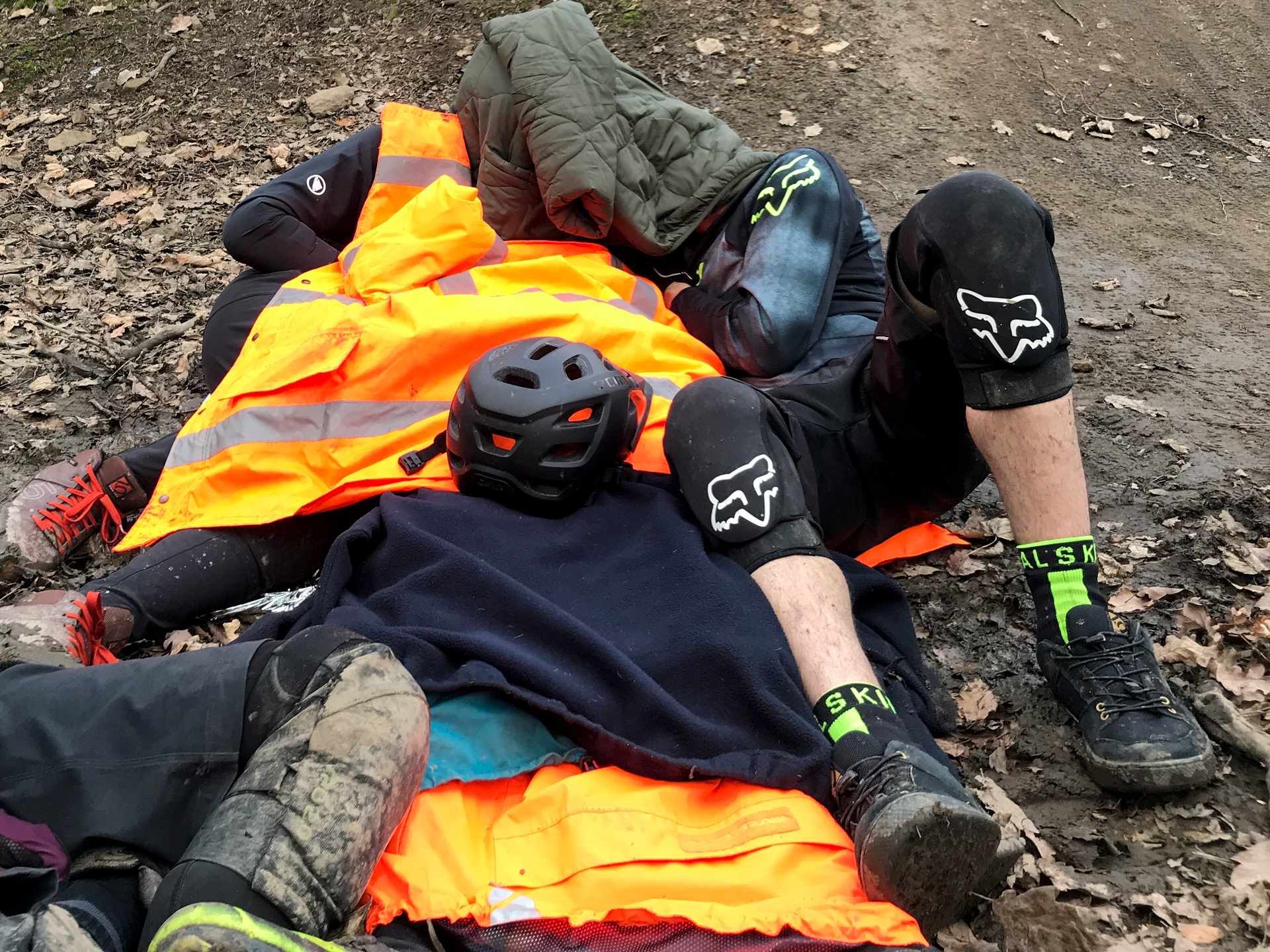
So if you are using a system to summon help over the phone in an emergency, or relying on it to send resources to the right location to provide that help, how do you get it right? W3W is already widely used by police and ambulance services. It’s easier to train on than traditional grid references, and in many cases a better solution than relying on postcodes 9which are generally hopeless away from urban areas). So search and rescue teams are adapting their working to make sure things go to plan. But as a mountain biker, ready for anything, what can you do to make sure it all goes smoothly when it all goes wrong? Imagine a great ride has abruptly gone south when your mate misjudged a drop and landed on their head. They’ve briefly lost consciousness, their helmet is trashed and they’re in pain. Someone else is taking care of the first aid – it’s your job to summon help…
What Mountain Rescue REALLY needs to know when you call…
- Know where you are
I know this sounds obvious, and is the sort of thing said with smug hindsight, but a bit of forethought can go a long way in the event of an accident. Having a navigational awareness of where you are riding is invaluable. That well-worn trail centre red route you ride all the time… if you weren’t following the arrows would you know where you are? If a mate is guided you round an unfamiliar area, maybe scan a map with them first. Do you have an idea of the quick escape routes, how far you might need to go to get a phone signal, or where the nearest tarmac road is? - Now REALLY know where you are
If things go tits-up you need to know where you are and be able to tell someone else exactly where you are. There isn’t a single right answer to this one. Using a map is an important skill, but if you need your location quickly nothing beats a GPS device. Apps like What3Words and OS Locate are great for giving you a precise spot using your phone, but it’s more important to be accurate than precise. A w3w location with a misheard word will precisely locate a 3x3m square that isn’t where you are. Think about what the location is you want to communicate – casualty site, where you are, the nearest road access. If you need to move to get phone reception, record the casualty location before you do. Stop Strava and give any device time to settle and locate itself securely. I’ve set my Garmin watch to give me a 10-figure grid reference at the press of a button, but it takes a while to locate itself – if I read it too soon I’ll have a grid that might be very precise (10 figures describes a 1x1m square) but wildly inaccurate. Once you are happy with the location then make sure you record it accurately (write it on your hand, copy and paste it into a note, etc). Now think about the other information you can give to help avoid any mistakes – a bit of real-world context can go a long way. Are you: east or west of that ridge line; on the north or south bank of that river; on a track heading west from X village; just after marker post 21 on the red route – all that sort of information will help confirm to a rescuer that your spot location makes sense. - Take your time
Mistakes in passing location information probably cause the biggest delays in getting help to casualties in Mountain Rescue. Being calm and taking two minutes to confirm and check your location could save 30 minutes or more in response time. If you can move away from the casualty to sort it out without distraction all the better. Location is the very first thing you should provide – ‘Exact location’ is the E in ETHANE. If you are giving a grid reference, ask the call handler to repeat it back. If you are sending a w3w location spell out each word for them. Avoid getting stuck needing to look at your phone while making the call – write things down or record the location on someone else’s phone. If it’s not windy you could put your phone on speaker. - ETHANE
E – Exact Location
T- Type of Incident
H – Hazards
A – Access Routes
N – No & Type of casualties
E – Emergency Services - Call the right people
If someone is injured the temptation is always to call for an ambulance, but if the casualty is any distance from a road, calling Mountain Rescue maybe your best option. Dial 999, ask for the police, and then ask for Mountain Rescue. They will take your information and pass it directly to the team covering that area. The Mountain Rescue team will sort out getting an ambulance when and where it is needed. Ambulance control rooms will often also activate a Mountain Rescue team to an incident, but this can often be at the request of an ambulance or air ambulance crew already on the ground, so can delay the response a bit. - Keep in touch
Where possible try and stay somewhere with a phone signal. A Mountain Rescue team will nearly always attempt to contact a caller to confirm details or send a text message with a link to confirm the exact location (using a system called PhoneFind). Obviously, this also relies on having a phone with a reasonable battery charge. If you’re off on a big day adventure, consider having one of your party switching their phone off and stashing it safe in a bag, so you know you’ve got a charged phone in case of emergency. If you’re using phone apps for navigation remember that they can suck your battery dry quite quickly, so plan ahead. - Make yourselves comfortable and visible
If you’re in a remote spot help may take a while to get there. Make sure everyone in the party, and especially the casualty, is warm enough (even in summer a high proportion of our casualties are hypothermic). And make yourselves as visible as possible to those responding so you can direct to the casualty. Get someone out from under tree cover, or at a trail entrance, or at the nearest track junction. If there’s other people about then this is a useful job to ask willing bystanders to do for you.
Remember that rescue services will do the best they can with the information you give them, regardless of what form it takes. Your job is to give them the best quality information you can, which will get any rescue off to a good start. Whether that’s What3Words, a grid reference, a homing beacon – the most important job is to make sure that it points to the correct place
Check out the fuss over at What3Words HQ: what3words.com
Join our mailing list to receive Singletrack editorial wisdom directly in your inbox.
Each newsletter is headed up by an exclusive editorial from our team and includes stories and news you don’t want to miss.
Some good advice in here. Thanks.
Sensible and balanced.
Today I learned why we call the police first!
Yeah, I didn’t know “ask for the police, and then ask for Mountain Rescue” either!
The “call the right people” seems completely backwards, is that really how it works? I’ve only had to call out emergency services in the hills once, and I said “ambulance but it’ll need mountain rescue too”, and that’s what happened. Would never occur to me to involve the police in that, I mean why would you?
Didn’t realise I could change the location format on my Garmin to OS Grid – good tip!!
Is there a reliable Android app to just tell me the grid reference I’m at? Even the free ones pile too many bells and whistles on for my tastes.
If the Mountain Rescue Team send you a Phone Finder make sure you set your Privacy Settings to allow your location to be found. We find quite a few iPhone users don’t set this correctly and their PhoneFinder Message is not activated when they accept the SMS message.
For iOS Settings > Privacy > Location Services > Share my location – Slide the Toggle for Share my Location to Green.
@Northwind Police have the responsibility for all Land based Search and Rescue in the UK so are supposed to activate MR teams to attend callouts. Most of the MR teams now have a Memorandum of Understanding (MOU) with their local Ambulance Service that will allow them to be called directly by the ambulance service as well. But the official line is still via the Police.
My experience of a badly injured friend mountain biking in the Surrey Hills a few years ago is that W3W would have been perfect but didn’t exist then.
I knew exactly where we were and exactly where the ambulance needed to access the nearby fire road – but it was confusing and frustrating trying to explain that to an emergency services operator who was used to dealing with streets and postcodes.
Using W3W in that case would have saved a lot of bother and time.
“Hello, my friend just landed on his head and can’t remember how he got here, I think I need an Ambulance.”
“OK, where are you?”
“I’m in Ae forest.”
“Yes, but which forest?”
“It’s Ae forest, near to Ae village.”
“OK….and which village is that?”
Can’t remember if we asked for Police or Ambulance but was v grateful to be able to use OS Locate at Brechfa to give exact coordinates a few years ago that triggered an amazing quick response by the air ambulance. Good article. One thing I’d query is ability on a trail centre to know where you are. Even if good navigationally, translating where you are on the trail into a good location-description or into finding yourself on an OS map can be difficiult. Undulating valleys, forest that all looks same and many interconnected forestry roads make it confusing. OSlocate or W3W can be invaluable.
Used W3W when talking to the Police recently when we found an artillery shell while doing volunteer with the RSPB. He took the words and then described back to me where he thought we were, which was an exact match, ok we were literally next to a road, but it was a remote heathland area.
Also I didn’t know about changing my Garmin Instinct to OS map ref rather than Lat and Long. Good tip, now changed it. Thanks
This site highlights some of the issues with W3W https://shkspr.mobi/blog/2019/03/why-bother-with-what-three-words/
My issue with W3W is it is forcing frontline services (and essentially taxpayer/sponsors) to foot the cost for a large advertising campaign and organization costs/profits which could easily be circumvented by industry adoption of some open standards incorporated into telecomms governance.
Maybe what we need is OS to do a campaign about reading maps and using grid refs.
FFS it’s pretty basic stuff that 12 year olds can understand in 2ndary school geography or in scouts.
But is being made 10 times more complicated than necessary to sell and profit from tech.
Now put a glaswegian accent on the 3 words over a shiiite connection and try it again…
Sure, but the same is true of Lat/Long or OS Grid numbers, they can be misheard, transposed, or just wrong. Same is true of road numbers, the M60, M61, M62, M65 M66, all motorways around Manchester but the M69? Leicester to Coventry, so that makes sense..There’s much to criticize W3W about, but some of their problems are everyone else’s problems as well, and are just to do with humans
“Maybe what we need is OS to do a campaign about reading maps and using grid refs.”
I can read a map but if I’m first on scene at an accident, or a heart attack, I don’t want to be reading a map. If I’m the casualty I definitely don’t want to be reading a map. If I’m riding locally, I don’t carry a map. If I’m riding not locally, I probably don’t own the map.
Reading maps is a good skill, but in the mobile phone age it makes no sense at all not to use that resource. The answer to “is W3W a good way to do it” is either “Yes” or “no, we should have a better phone method”, it’s definitely not “let’s teach everyone to read maps”
Thanks Richardoftod, that still seems crazy- something that really needs to be fixed at an institutional level rather than expecting people to know to ask for the police for a medical emergency…
We were dog walking in the roughish terrain near Farnham on Sunday early evening when we came across a family with a teen on the ground with a dislocated knee.
The family who were out for a simple stroll used wot3words and their ambulance had arrived. (It took 2hrs but that isn’t the fault of the system.).
Describing where you are in that rabbit warren of trails through woods and scrub would be a nightmare. I’m not certain that “… you know that bit of land where they filmed Skyfall?” would be too much help but the app did the job.